パムリコ郡 (ノースカロライナ州)
| ノースカロライナ州パムリコ郡 | |
|---|---|
 郡のノースカロライナ州内の位置
| |
 州のアメリカ合衆国内の位置
| |
| 設立 | 1872年 |
| 郡庁所在地 | ベイボロ |
| 面積 - 総面積 - 陸 - 水 |
1,466 km2 (566 mi2) 873 km2 (337 mi2) 593 km2 (229 mi2), 40.49% |
| 人口 - (2010年) - 密度 |
13,144人 15人/km2 (39人/mi2) |
| 標準時 | 東部: UTC-5/-4 |
| ウェブサイト | www |
パムリコ郡(パムリコぐん、英: Pamlico County、 [ˈpæmlɪkoʊ]) [1])は、アメリカ合衆国ノースカロライナ州の南東部、大西洋岸に位置する郡である。2010年国勢調査での人口は13,144人であり、2000年の12,934人から1.6%増加した[2]。郡庁所在地はベイボロ町(人口1,263人[3])であり、同郡で人口最大の町でもある。
歴史
[編集]パムリコ郡は1872年に、ボーフォート郡とクレイブン郡の一部を合わせて設立された。郡名は隣接するパムリコ湾から採られた。パムリコ郡は性格も雰囲気も田園部のままであるが、この10年間ではかなりの住宅開発が進んでいる。これには長い海岸線に惹きつけられた北部の引退者は投資家の存在が大きい。東部にオリエンタルの町があり、沿岸内水路を旅する出発点になっている。西部には未編入の町オリンピアがあり、西部にも同じく未編入のローランドの町がある。西隣のクレイブン郡にはニューバーンの町があり、交易地域となっている。

郡政府
[編集]パムリコ郡は7人の委員で構成される郡政委員会が統治している[4]。
パムリコ郡は、地域自治体の組織である東部カロライナ自治体委員会のメンバーである。
地理
[編集]アメリカ合衆国国勢調査局に拠れば、郡域全面積は566平方マイル (1,470 km2)であり、このうち陸地337平方マイル (870 km2)、水域は229平方マイル (590 km2)で水域率は40.49%である[5]。
郡区
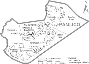
[編集]パムリコ郡は5つの郡区に分割されている。郡庁所在地のベイボロは第2郡区に、オリエンタルの町も第2郡区に入っている。
隣接する郡
[編集]
|
ボーフォート郡 | ハイド郡 | 
| |
| クレイブン郡 | パムリコ湾 | |||
| クレイブン郡 | カータレット郡 |
人口動態
[編集]|
基礎データ
人種別人口構成
|
年齢別人口構成
世帯と家族(対世帯数)
|
収入[編集]収入と家計 |
都市と町
[編集]
|
|
|
脚注
[編集]- ^ Talk Like A Tarheel, from the North Carolina Collection's website at the University of North Carolina at Chapel Hill. Retrieved 2013-02-05.
- ^ Quickfacts.census.gov - Pamlico County Archived 2011年7月16日, at WebCite - accessed 2011-12-06.
- ^ American FactFinder - Bayboro, North Carolina - accessed 2011-12-06.
- ^ Board of Commissioners
- ^ “Census 2010 U.S. Gazetteer Files: Counties”. United States Census. 2013年4月13日閲覧。
外部リンク
[編集]- Pamlico County government official website - 公式サイト
- Pamlico County Chamber of Commerce
- NCGenWeb Pamlico County - free genealogy resources for the county
- The Pamlico News - The Weekly Newspaper for Pamlico County
- The County Compass - Weekly newspaper serving Pamlico County, NC
- TownDock.net - News - Views - Web Cams - Weather from Oriental, NC
- Town of Oriental Visitor's Information
- Official Website of the Town of Oriental
座標: 北緯35度09分 西経76度40分 / 北緯35.15度 西経76.67度
Text is available under the CC BY-SA 4.0 license; additional terms may apply.
Images, videos and audio are available under their respective licenses.
