For faster navigation, this Iframe is preloading the Wikiwand page for バンクス半島.

バンクス半島

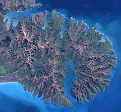
バンクス半島衛星写真
バンクス半島の位置
バンクス半島鳥瞰図

バンクス半島: Banks Peninsula)は、ニュージーランド南島クライストチャーチから南東に広がる半島である。半島の面積は約1,000平方キロメートル。

半島はリトルトン火山とアカロア火山の主に2つの複合楯状火山が浸食されてできたもので、これは南島で最も著名な火山地形である[1]。ニュージーランドの南島でも有名な観光地、保養地であり、おしゃれな町が点在している。1830年代には捕鯨基地として栄え、1840年代にフランス人が入植した地区であり、現在でもヨーロッパ調の建物が多く残っている。

クライストチャーチから直線距離で南西に40キロメートル(75号線での距離は約85キロメートル)にあるアカロアが最大の町であり、ここから遊覧観光船が出ている。「バンクス半島海生哺乳類保護区」に指定されているこの海域には様々な生物が生息し、遊覧船に乗り貴重なセッパリイルカニュージーランドオットセイシャチなどの海洋生物を観察できる。

脚注

[編集]
  1. ^ Oxford Journals

外部リンク

[編集]

座標: 南緯43度45分00秒 東経172度49分59秒 / 南緯43.750度 東経172.833度 / -43.750; 172.833

{{bottomLinkPreText}} {{bottomLinkText}}
バンクス半島
Listen to this article

This browser is not supported by Wikiwand :(
Wikiwand requires a browser with modern capabilities in order to provide you with the best reading experience.
Please download and use one of the following browsers:

This article was just edited, click to reload
This article has been deleted on Wikipedia (Why?)

Back to homepage

Please click Add in the dialog above
Please click Allow in the top-left corner,
then click Install Now in the dialog
Please click Open in the download dialog,
then click Install
Please click the "Downloads" icon in the Safari toolbar, open the first download in the list,
then click Install
{{::$root.activation.text}}

Install Wikiwand

Install on Chrome Install on Firefox
Don't forget to rate us

Tell your friends about Wikiwand!

Gmail Facebook Twitter Link

Enjoying Wikiwand?

Tell your friends and spread the love:
Share on Gmail Share on Facebook Share on Twitter Share on Buffer

Our magic isn't perfect

You can help our automatic cover photo selection by reporting an unsuitable photo.

This photo is visually disturbing This photo is not a good choice

Thank you for helping!


Your input will affect cover photo selection, along with input from other users.

X

Get ready for Wikiwand 2.0 🎉! the new version arrives on September 1st! Don't want to wait?