ニウエの地理

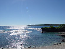
ニウエの地理(ニウエのちり)について記述する。ニウエはトンガの東に位置する、南太平洋の小さな島である。面積は260km2[1]で海岸線長は64kmである。排他的経済水域は200海里、領海は12海里を主張している。世界最大のサンゴ島の1つである。
ニウエはニュージーランドと自由連合の関係にあり、中華人民共和国から国家の承認を受けているほか、日本政府も2015年5月15日に国家承認したことを発表した[2]。首都はアロフィに置かれている[1]。
位置
[編集]
ニウエは南緯19度、西経169度に位置しており、サモア諸島まで北へ約600km、クック諸島まで東へ約950km、トンガ諸島まで西へ約420kmである[3]。 ニウエの東西南北端は次の通りである。
気候
[編集]ニウエの気候は熱帯であり、南東貿易風に左右される。12月 - 3月の雨季は高温多湿であり、その他の月は少雨でやや涼しい乾季となる[3]。雨季にはしばしばハリケーンやサイクロンが襲来する[3]。
| アロフィの気候 | |||||||||||||
|---|---|---|---|---|---|---|---|---|---|---|---|---|---|
| 月 | 1月 | 2月 | 3月 | 4月 | 5月 | 6月 | 7月 | 8月 | 9月 | 10月 | 11月 | 12月 | 年 |
| 最高気温記録 °C (°F) | 38 (100) |
38 (100) |
32 (90) |
36 (97) |
30 (86) |
32 (90) |
35 (95) |
37 (99) |
36 (97) |
31 (88) |
37 (99) |
36 (97) |
38 (100) |
| 平均最高気温 °C (°F) | 28 (82) |
29 (84) |
28 (82) |
27 (81) |
26 (79) |
26 (79) |
25 (77) |
25 (77) |
26 (79) |
26 (79) |
27 (81) |
28 (82) |
27 (81) |
| 日平均気温 °C (°F) | 26 (79) |
27 (81) |
26 (79) |
25 (77) |
25 (77) |
23 (73) |
22 (72) |
23 (73) |
23 (73) |
24 (75) |
25 (77) |
26 (79) |
25 (77) |
| 平均最低気温 °C (°F) | 23 (73) |
24 (75) |
24 (75) |
23 (73) |
22 (72) |
21 (70) |
20 (68) |
20 (68) |
21 (70) |
21 (70) |
22 (72) |
23 (73) |
22 (72) |
| 最低気温記録 °C (°F) | 20 (68) |
20 (68) |
20 (68) |
14 (57) |
15 (59) |
13 (55) |
11 (52) |
11 (52) |
15 (59) |
15 (59) |
11 (52) |
17 (63) |
11 (52) |
| 降水量 cm (inch) | 26 (10.2) |
25 (9.8) |
30 (11.8) |
20 (7.9) |
13 (5.1) |
8 (3.1) |
9 (3.5) |
10 (3.9) |
10 (3.9) |
12 (4.7) |
14 (5.5) |
19 (7.5) |
207 (81.5) |
| 出典:Weatherbase[4] | |||||||||||||
地形
[編集]ニウエの地形は石灰岩の急な沿岸の崖と、中央部の台地から構成される。最低標高は海面と同じ0m、最高標高はマタラウ村にある無名の地点の68mである。
資源と土地利用
[編集]島の資源は魚と農地である。1993年現在の土地利用は以下の通り。
| 土地利用 | 比率(%) |
|---|---|
| 農地 | 19 |
| 恒久的な作付地 | 8 |
| 恒久的な牧草地 | 4 |
| 森林 | 19 |
| その他 | 50 |
環境問題
[編集]ニウエでは焼畑農業による地力の低下に対する保護活動の実践を通して環境問題への関心が高まりつつある。ニウエは生物の多様性に関する条約、気候変動枠組条約、京都議定書、国連砂漠化対処条約を結んでいる。海洋法に関する国際連合条約(国連海洋法条約)には署名しているが、批准はしていない。
国境
[編集]ニウエはアメリカ領サモアとの間の東西の海上境界線の画定に関する協定をアメリカ合衆国と締結している。ニウエはアメリカ領サモアの南にある。
民族
[編集]ニウエの人口は2011年現在1,426人である[1]。2001年現在の民族構成は、ニウエ人が78.2%、太平洋諸島民が10.2%、ヨーロッパ系が4.5%、混血が3.9%である[1]。なおニウエには日本人の経営する寿司屋「Kai Ika」があり、テレビ東京系列の番組『世界の秘境で大発見!日本食堂』で紹介された[5]。
参考文献
[編集]- 二宮書店編集部 編『データブック オブ・ザ・ワールド 2012年版』二宮書店、2012年1月10日、479p. ISBN 978-4-8176-0358-6
- 馬場優子(1996)"ニウエ島の村落生活"大妻女子大学紀要.文系.28:138-124.
脚注
[編集]外部リンク
[編集]座標: 南緯19度02分 西経169度52分 / 南緯19.033度 西経169.867度
| 大陸部 |
| ||||||||
|---|---|---|---|---|---|---|---|---|---|
| ポリネシア |
| ||||||||
| ミクロネシア |
| ||||||||
| メラネシア |
| ||||||||
| インド洋 |
| ||||||||
| 太平洋(その他) |
| ||||||||
|
各列内は五十音順。オーストララシアという区分もある。
関連カテゴリ:Category:大陸別の地理 Category:地域別の地理 Category:各国の地理
| |||||||||
Text is available under the CC BY-SA 4.0 license; additional terms may apply.
Images, videos and audio are available under their respective licenses.
