For faster navigation, this Iframe is preloading the Wikiwand page for デービス海峡.

デービス海峡

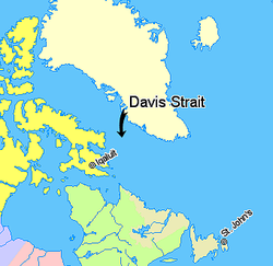
デービス海峡とその周辺の地図

デービス海峡: Davis Strait: Détroit de Davis)は、グリーンランドカナダヌナブト準州バフィン島との間に位置する海峡。海峡の幅は広く、最狭部でも約338kmある。一方水深は1,000-2,000m程度で、北のバフィン湾や南のラブラドル海よりもかなり浅い。

一帯の海底の地形は複雑で、断層によって地溝や海底山脈が形成されている。こうした断層は4500万-6200万年ほど前、古第三紀プレートの活動により形成されたものと見られている。

海峡の名は16世紀大航海時代北西航路を探索したイギリスの探検家、ジョン・デービスに由来している[1]。デービスは1585年にこの海峡を通過した。

海峡はただでさえ高緯度である上、ラブラドル海流という寒流が流れており、その海水温は極めて低い。冬は流氷により船舶の航行は困難となる。また海峡の周辺の陸地の気候は寒帯ツンドラ気候となっている。

脚注

[編集]
  1. ^ Maxine Snowden『北極・南極探検の歴史 極限の世界を体感する19のアクティビティ』丸善出版、2016年、19頁。ISBN 978-4-621-30068-8 

参考文献

[編集]

外部リンク

[編集]

座標: 北緯65度 西経58度 / 北緯65度 西経58度 / 65; -58

{{bottomLinkPreText}} {{bottomLinkText}}
デービス海峡
Listen to this article

This browser is not supported by Wikiwand :(
Wikiwand requires a browser with modern capabilities in order to provide you with the best reading experience.
Please download and use one of the following browsers:

This article was just edited, click to reload
This article has been deleted on Wikipedia (Why?)

Back to homepage

Please click Add in the dialog above
Please click Allow in the top-left corner,
then click Install Now in the dialog
Please click Open in the download dialog,
then click Install
Please click the "Downloads" icon in the Safari toolbar, open the first download in the list,
then click Install
{{::$root.activation.text}}

Install Wikiwand

Install on Chrome Install on Firefox
Don't forget to rate us

Tell your friends about Wikiwand!

Gmail Facebook Twitter Link

Enjoying Wikiwand?

Tell your friends and spread the love:
Share on Gmail Share on Facebook Share on Twitter Share on Buffer

Our magic isn't perfect

You can help our automatic cover photo selection by reporting an unsuitable photo.

This photo is visually disturbing This photo is not a good choice

Thank you for helping!


Your input will affect cover photo selection, along with input from other users.

X

Get ready for Wikiwand 2.0 🎉! the new version arrives on September 1st! Don't want to wait?