For faster navigation, this Iframe is preloading the Wikiwand page for タナミ砂漠.

タナミ砂漠

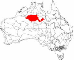
地図中の赤い地域がタナミ砂漠

タナミ砂漠 (Tanami Desert) は、オーストラリアノーザンテリトリーにある砂漠。岩の多く、小さな丘が点在する地域である。タナミ砂漠は、ノーザンテリトリー最後の辺境であり、20世紀に入るまで完全には探検されていなかった。タナミ・トラックと呼ばれる道路が西オーストラリア州と結ぶ。

  • 面積: 37,529 km²
  • 降雨記録のあるタナミ砂漠に最も近い場所はラビットフラット
  • 年間降水量: 429.7 mm
  • 一日の平均最高気温: 33.5 °C
  • 一日の平均最低気温: 16.4 °C
  • 晴れの日の平均日数 169日
  • 一日の平均蒸発量 7.6 mm
{{bottomLinkPreText}} {{bottomLinkText}}
タナミ砂漠
Listen to this article

This browser is not supported by Wikiwand :(
Wikiwand requires a browser with modern capabilities in order to provide you with the best reading experience.
Please download and use one of the following browsers:

This article was just edited, click to reload
This article has been deleted on Wikipedia (Why?)

Back to homepage

Please click Add in the dialog above
Please click Allow in the top-left corner,
then click Install Now in the dialog
Please click Open in the download dialog,
then click Install
Please click the "Downloads" icon in the Safari toolbar, open the first download in the list,
then click Install
{{::$root.activation.text}}

Install Wikiwand

Install on Chrome Install on Firefox
Don't forget to rate us

Tell your friends about Wikiwand!

Gmail Facebook Twitter Link

Enjoying Wikiwand?

Tell your friends and spread the love:
Share on Gmail Share on Facebook Share on Twitter Share on Buffer

Our magic isn't perfect

You can help our automatic cover photo selection by reporting an unsuitable photo.

This photo is visually disturbing This photo is not a good choice

Thank you for helping!


Your input will affect cover photo selection, along with input from other users.

X

Get ready for Wikiwand 2.0 🎉! the new version arrives on September 1st! Don't want to wait?