セグー
セグー Ségou | |
|---|---|
|
コミューンおよび町 | |
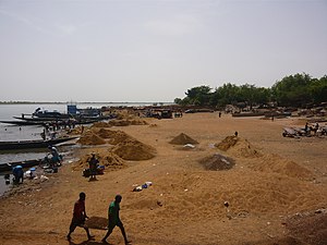
 ニジェール川のほとりの労働者 | |
 セグー・コミューンの地図 | |
| 座標:北緯13度27分 西経6度16分 / 北緯13.450度 西経6.267度座標: 北緯13度27分 西経6度16分 / 北緯13.450度 西経6.267度 | |
| 国 |
|
| 州 | セグー州 |
| 圏 | セグー圏 |
| 面積 | |
| • 合計 | 37 km2 |
| 標高 | 294 m |
| 人口 (2009 census)[2] | |
| • 合計 | 130,690人 |
| • 密度 | 3,500人/km2 |
| 等時帯 | UTC+0 (GMT) |
 セグー・コミューンの地図 セグー・コミューンの地図 | |
セグー (フランス語: Ségou) は、マリ共和国のセグー州にある都市。セグー州の州都でもある[3]。人口13万690人(2009年国勢調査)[2]、標高294m。
18世紀初頭、セグーを都とするバンバラ王国(セグー王国)が勃興しニジェール川中流域を支配すると、セグーはこの一帯の中心として繁栄するようになった[4]。1861年にバンバラ王国はエルハジ・ウマール率いるトゥクロール帝国に滅ぼされたが、トゥクロール帝国はそのままセグーに都をおき、1890年にフランスに滅ぼされるまでこの一帯を支配していた。
セグーはバンバラ王国の都だったこともあり、現代でも人口の半数はバンバラ人が占めている。そのほか、ボゾ人やソニンケ人をはじめとする様々な民族が居住している[5]。
| セグー (1961–1990)の気候 | |||||||||||||
|---|---|---|---|---|---|---|---|---|---|---|---|---|---|
| 月 | 1月 | 2月 | 3月 | 4月 | 5月 | 6月 | 7月 | 8月 | 9月 | 10月 | 11月 | 12月 | 年 |
| 平均最高気温 °C (°F) | 31.9 (89.4) |
35.2 (95.4) |
37.8 (100) |
39.3 (102.7) |
39.2 (102.6) |
36.3 (97.3) |
32.6 (90.7) |
31.1 (88) |
32.3 (90.1) |
35.3 (95.5) |
35.2 (95.4) |
32.0 (89.6) |
34.8 (94.6) |
| 日平均気温 °C (°F) | 24.2 (75.6) |
27.0 (80.6) |
29.7 (85.5) |
31.7 (89.1) |
32.4 (90.3) |
30.4 (86.7) |
27.7 (81.9) |
26.5 (79.7) |
27.0 (80.6) |
28.2 (82.8) |
26.8 (80.2) |
24.3 (75.7) |
28.0 (82.4) |
| 平均最低気温 °C (°F) | 16.4 (61.5) |
19.3 (66.7) |
22.3 (72.1) |
25.2 (77.4) |
26.5 (79.7) |
24.9 (76.8) |
23.1 (73.6) |
22.5 (72.5) |
22.4 (72.3) |
22.2 (72) |
19.5 (67.1) |
16.9 (62.4) |
21.8 (71.2) |
| 降水量 mm (inch) | 0.3 (0.012) |
0.1 (0.004) |
2.7 (0.106) |
11.9 (0.469) |
32.9 (1.295) |
71.9 (2.831) |
160.7 (6.327) |
210.2 (8.276) |
116.1 (4.571) |
25.7 (1.012) |
1.4 (0.055) |
1.0 (0.039) |
634.9 (24.996) |
| 平均降水日数 | 0.2 | 0.1 | 0.4 | 2.0 | 4.9 | 8.6 | 14.1 | 17.1 | 11.2 | 3.3 | 0.2 | 0.1 | 62.2 |
| 平均月間日照時間 | 281.2 | 256.1 | 275.1 | 253.1 | 264.4 | 253.9 | 248.7 | 231.0 | 241.5 | 272.4 | 264.8 | 271.7 | 3,113.9 |
| 出典:NOAA[6] | |||||||||||||
姉妹都市
[編集]脚注
[編集]- ^ Common and Fundamental Operational Datasets Registry: Mali, United Nations Office for the Coordination of Humanitarian Affairs, オリジナルの2012-01-06時点におけるアーカイブ。. commune_mali.zip (Originally from the Direction Nationale des Collectivités Territoriales, République du Mali)
- ^ a b (French) Resultats Provisoires RGPH 2009 (Région de Ségou), République de Mali: Institut National de la Statistique.
- ^ “Regions of Mali”. Statoids (2016年1月25日). 2024年5月28日閲覧。
- ^ 「マリを知るための58章」内収録「バンバラ王国」p66-69 坂井信三 竹沢尚一郎編著 明石書店 2015年11月15日初版第1刷発行
- ^ 「マリを知るための58章」内収録「セグ」p170 ウスビ・サコ 竹沢尚一郎編著 明石書店 2015年11月15日初版第1刷発行
- ^ “Segou Climate Normals 1961–1990”. National Oceanic and Atmospheric Administration. 2015年10月12日閲覧。
| 全般 | |
|---|---|
| 国立図書館 | |
| その他 | |
Text is available under the CC BY-SA 4.0 license; additional terms may apply.
Images, videos and audio are available under their respective licenses.


