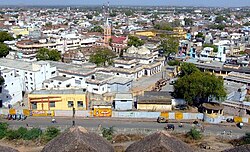
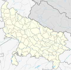
ジャーンシー
| ジャーンシー Jhansi | |
|---|---|
 ジャーンシー | |
| 位置 | |

| |
| 座標 : 北緯25度26分55秒 東経78度34分11秒 / 北緯25.44861度 東経78.56972度 | |
| 行政 | |
| 国 | |
| 州 | ウッタル・プラデーシュ州 |
| 県 | ジャーンシー県 |
| 市 | ジャーンシー |
| 地理 | |
| 面積 | |
| 市域 | ? km2 |
| 標高 | 285 m |
| 人口 | |
| 人口 | (2011年現在) |
| 市域 | 505,693 [1]人 |
| 都市圏 | 547,638[1][2][3]人 |
| その他 | |
| 等時帯 | IST (UTC+5:30) |
| Pincode | 284001-2-3-4 |
| 市外局番 | 0510 |
| ナンバープレート | UP-93 |
ジャーンシー(ヒンディー語:झाँसी、英語:Jhansi)は、インドのウッタル・プラデーシュ州、ジャーンシー県の都市。
歴史
[編集]かつて、マラーター同盟に属したジャーンシー王国の首都であり、1804年にはイギリスと軍事保護条約を締結、藩王国化した。
1853年、最後の藩王ガンガーダル・ラーオが嫡子無くして死亡し、1854年に藩王国はイギリスに併合された。
1857年、インド大反乱が勃発すると、王妃のラクシュミー・バーイーが立ち上がり、ジャーンシーの民衆の推戴を受け、執政となった。そしてジャーンシー城を奪還し抵抗を続け、城が陥落する1858年まで抵抗を続けた。
気候
[編集]| Jhansi (1971–2000)の気候 | |||||||||||||
|---|---|---|---|---|---|---|---|---|---|---|---|---|---|
| 月 | 1月 | 2月 | 3月 | 4月 | 5月 | 6月 | 7月 | 8月 | 9月 | 10月 | 11月 | 12月 | 年 |
| 最高気温記録 °C (°F) | 33.8 (92.8) |
39.4 (102.9) |
43.3 (109.9) |
46.2 (115.2) |
48.0 (118.4) |
47.8 (118) |
45.6 (114.1) |
42.2 (108) |
40.6 (105.1) |
40.6 (105.1) |
38.1 (100.6) |
33.1 (91.6) |
48.0 (118.4) |
| 平均最高気温 °C (°F) | 23.3 (73.9) |
26.9 (80.4) |
33.3 (91.9) |
39.3 (102.7) |
42.3 (108.1) |
40.5 (104.9) |
34.0 (93.2) |
32.2 (90) |
33.3 (91.9) |
33.9 (93) |
29.6 (85.3) |
24.5 (76.1) |
32.9 (91.2) |
| 平均最低気温 °C (°F) | 7.4 (45.3) |
10.3 (50.5) |
15.8 (60.4) |
21.9 (71.4) |
26.3 (79.3) |
27.3 (81.1) |
24.6 (76.3) |
23.7 (74.7) |
22.8 (73) |
19.1 (66.4) |
13.2 (55.8) |
8.5 (47.3) |
18.4 (65.1) |
| 最低気温記録 °C (°F) | 1.2 (34.2) |
0.6 (33.1) |
5.3 (41.5) |
10.1 (50.2) |
15.1 (59.2) |
18.5 (65.3) |
20.3 (68.5) |
18.3 (64.9) |
16.7 (62.1) |
10.7 (51.3) |
1.1 (34) |
0.3 (32.5) |
0.3 (32.5) |
| 降水量 mm (inch) | 9.2 (0.362) |
9.6 (0.378) |
7.7 (0.303) |
2.3 (0.091) |
13.9 (0.547) |
85.0 (3.346) |
270.4 (10.646) |
286.2 (11.268) |
165.3 (6.508) |
31.8 (1.252) |
6.3 (0.248) |
3.6 (0.142) |
891.3 (35.091) |
| 平均降雨日数 | 0.9 | 1.0 | 0.7 | 0.5 | 1.3 | 4.9 | 12.3 | 13.1 | 7.0 | 1.6 | 0.5 | 0.5 | 44.2 |
| 出典:India Meteorological Department (record high and low up to 2010)[4][5] | |||||||||||||
ギャラリー
[編集]
出典・脚注
[編集]- ^ a b “Census of India: Jhansi city”. www.censusindia.gov.in. 2019年11月23日閲覧。
- ^ “Census of India: Jhansi Cantonment”. www.censusindia.gov.in. 2019年11月23日閲覧。
- ^ “Census of India: Jhansi Railway Settlement”. www.censusindia.gov.in. 2019年11月23日閲覧。
- ^ “Jhansi Climatological Table Period: 1971–2000”. India Meteorological Department. 2015年4月15日閲覧。
- ^ “Ever recorded Maximum and minimum temperatures up to 2010” (PDF). India Meteorological Department. 2013年5月21日時点のオリジナルよりアーカイブ。2015年4月15日閲覧。
関連項目
[編集]外部リンク
[編集]Text is available under the CC BY-SA 4.0 license; additional terms may apply.
Images, videos and audio are available under their respective licenses.


