サントメ
| サン・トメ São Tomé | |||||
|---|---|---|---|---|---|
.jpg) サントメの通り(2015年) | |||||
| |||||
| 位置 | |||||

| |||||
| 位置 | |||||
 サントメ サントメ (サントメ・プリンシペ)  サントメ サントメ (サントメ)  サントメ サントメ (アフリカ) | |||||

| |||||
| 座標 : 北緯0度20分10秒 東経6度40分53秒 / 北緯0.33611度 東経6.68139度 | |||||
| 歴史 | |||||
| 建設 | 1485年 | ||||
| 行政 | |||||
| 国 | |||||
| 州 | サントメ州 | ||||
| 県 | アグア・グランデ県 | ||||
| 市 | サン・トメ | ||||
| 地理 | |||||
| 面積 | |||||
| 市域 | 17 km2 | ||||
| 人口 | |||||
| 人口 | (2012年現在) | ||||
| 市域 | 67,000人 | ||||
| その他 | |||||
| 等時帯 | グリニッジ標準時 (UTC+0) | ||||
| 夏時間 | なし | ||||


サントメ(São Tomé)は、西アフリカ、ギニア湾にあるサントメ・プリンシペの首都で、同国の最大都市。サントメ島に位置する。人口6万7,000人(2012年推計)。サントメはポルトガル語で聖トマスに因み名付けられた。
歴史
[編集]1471年、ポルトガル人が渡来して植民地化、奴隷貿易の中継地とし、奴隷を使ってサトウキビ栽培を行った。16世紀には大聖堂が建設された。1575年にサン・セバスチャン砦(Forte de São Sebastião。現在のサントメ国立美術館にあった)が建てられた。1599年にサントメは2日間オランダに占領され、1641年には一年間占領された。19世紀にはコーヒーとカカオに作物が転換され、カカオの一大産地となった。
気候
[編集]| サントメ(サントメ国際空港)の気候 | |||||||||||||
|---|---|---|---|---|---|---|---|---|---|---|---|---|---|
| 月 | 1月 | 2月 | 3月 | 4月 | 5月 | 6月 | 7月 | 8月 | 9月 | 10月 | 11月 | 12月 | 年 |
| 最高気温記録 °C (°F) | 32.0 (89.6) |
33.6 (92.5) |
33.5 (92.3) |
33.4 (92.1) |
33.9 (93) |
31.0 (87.8) |
30.7 (87.3) |
31.0 (87.8) |
31.7 (89.1) |
31.5 (88.7) |
31.6 (88.9) |
32.0 (89.6) |
33.9 (93) |
| 平均最高気温 °C (°F) | 29.4 (84.9) |
29.9 (85.8) |
30.2 (86.4) |
30.1 (86.2) |
29.3 (84.7) |
28.0 (82.4) |
27.3 (81.1) |
27.7 (81.9) |
28.6 (83.5) |
28.7 (83.7) |
29.0 (84.2) |
29.1 (84.4) |
28.9 (84) |
| 日平均気温 °C (°F) | 25.9 (78.6) |
26.2 (79.2) |
26.4 (79.5) |
26.4 (79.5) |
26.0 (78.8) |
24.7 (76.5) |
23.8 (74.8) |
24.1 (75.4) |
25.0 (77) |
25.2 (77.4) |
25.5 (77.9) |
25.6 (78.1) |
25.4 (77.7) |
| 平均最低気温 °C (°F) | 22.4 (72.3) |
22.5 (72.5) |
22.6 (72.7) |
22.6 (72.7) |
22.6 (72.7) |
21.4 (70.5) |
20.4 (68.7) |
20.5 (68.9) |
21.3 (70.3) |
21.8 (71.2) |
22.0 (71.6) |
22.1 (71.8) |
21.8 (71.2) |
| 最低気温記録 °C (°F) | 19.1 (66.4) |
19.6 (67.3) |
19.2 (66.6) |
19.4 (66.9) |
18.5 (65.3) |
14.0 (57.2) |
14.0 (57.2) |
13.4 (56.1) |
16.0 (60.8) |
18.3 (64.9) |
18.8 (65.8) |
19.6 (67.3) |
13.4 (56.1) |
| 降水量 mm (inch) | 81 (3.19) |
84 (3.31) |
131 (5.16) |
122 (4.8) |
113 (4.45) |
19 (0.75) |
0 (0) |
1 (0.04) |
17 (0.67) |
110 (4.33) |
99 (3.9) |
108 (4.25) |
884 (34.8) |
| 平均降水日数 (≥0.1 mm) | 8 | 8 | 12 | 11 | 10 | 3 | 2 | 3 | 6 | 12 | 11 | 8 | 94 |
| % 湿度 | 85 | 84 | 83 | 83 | 84 | 79 | 77 | 78 | 79 | 82 | 85 | 85 | 82 |
| 平均月間日照時間 | 142.6 | 135.6 | 139.5 | 126.0 | 145.7 | 165.0 | 161.2 | 148.8 | 120.0 | 114.7 | 135.0 | 142.6 | 1,676.7 |
| 平均日照時間 | 4.6 | 4.8 | 4.5 | 4.2 | 4.7 | 5.5 | 5.2 | 4.8 | 4.0 | 3.7 | 4.5 | 4.6 | 4.6 |
| 出典:Deutscher Wetterdienst[1] | |||||||||||||
交通
[編集]サントメ国際空港がある。
ギャラリー
[編集]-
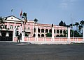 大統領宮殿
大統領宮殿 -
 サントメ市街地。黄色い車両はタクシー。
 -
 サントメの漁師。湾の奥側に市街地が見える。
 -
 サントメ市内の市場。
 -
 サン・トメ要塞


脚注
[編集]- ^ “Klimatafel von Sao Tomé (Flugh.) / Sao Tomé und Principe” (German). Baseline climate means (1961-1990) from stations all over the world. Deutscher Wetterdienst. January 26, 2016閲覧。
関連項目
[編集]外部リンク
[編集]- 295342933 サントメ - オープンストリートマップ
座標: 北緯0度20分10秒 東経6度40分53秒 / 北緯0.33611度 東経6.68139度
| 北アフリカ | |
|---|---|
| 西アフリカ | |
| 東アフリカ | |
| 中部アフリカ | |
| 南部アフリカ | |
| その他 | |
| 海外領土 | |
|
各列内は五十音順。「その他」は国家の承認を得る国が少ない、または無い国であり、国際連合非加盟。国家承認を得た国連非加盟の国と地域の一覧・独立主張のある地域一覧も参照。
| |
| 全般 | |
|---|---|
| 国立図書館 | |
| 地理 | |
| その他 | |
Text is available under the CC BY-SA 4.0 license; additional terms may apply.
Images, videos and audio are available under their respective licenses.
Cover photo is available under {{::mainImage.info.license.name || 'Unknown'}} license.
Cover photo is available under {{::mainImage.info.license.name || 'Unknown'}} license.
Credit:
(see original file).
