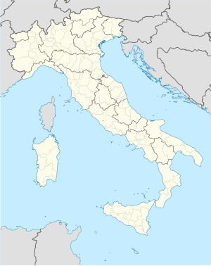
サチーレ
| サチーレ Sacile | |
|---|---|
 市内を流れるリヴェンツァ川 | |
| 行政 | |
| 国 |
|
| 州 |
|
| 県/大都市 |
|
| CAP(郵便番号) | 33077 |
| 市外局番 | 0434 |
| ISTATコード | 093037 |
| 識別コード | H657 |
| 分離集落 | #分離集落を参照 |
| 隣接コムーネ | #隣接コムーネ参照 |
| 公式サイト | リンク |
| 人口 | |
| 人口 | 19904 人 (2023-01-01 [1]) |
| 人口密度 | 610.2 人/km2 |
| 文化 | |
| 住民の呼称 | sacilesi |
| 守護聖人 |
ミラの聖ニコーラ (San Nicola di Mira) |
| 祝祭日 | 12月6日 |
| 地理 | |
| 座標 | 北緯45度57分14.83秒 東経12度30分09.86秒 / 北緯45.9541194度 東経12.5027389度座標: 北緯45度57分14.83秒 東経12度30分09.86秒 / 北緯45.9541194度 東経12.5027389度 |
| 標高 | 25 (13 - 42) [2] m |
| 面積 | 32.62 [3] km2 |
 | |
サチーレ(伊: Sacile)は、イタリア共和国フリウリ=ヴェネツィア・ジュリア州ポルデノーネ県にある、人口約20,000人の基礎自治体(コムーネ)。県内第二の人口を擁するコムーネである。
サチーレの街は、「セレニッシマ(ヴェネツィア共和国)の庭園(Giardino della Serenissima)」、「フリウーリの港(Porta del Friuli)」といった異称で知られる。リヴェンツァ川 (Livenza) が流れる旧市街には、ヴェネツィア共和国時代からの多くの邸宅が立ち並ぶ。
名称
[編集]標準イタリア語以外の言語では以下の名称を持つ。
- ヴェネト語: Sazhil
地理
[編集]位置・広がり
[編集]ポルデノーネ県南西部のコムーネで、西にトレヴィーゾ県(ヴェネト州)と境界を接する。サチーレの街は、県都ポルデノーネの西約11km、ヴィットリオ・ヴェネトの東約16km、トレヴィーゾの北北東約38kmに位置する[4]。

隣接コムーネ
[編集]隣接するコムーネは以下の通り。括弧内のTVはトレヴィーゾ県(ヴェネト州)所属を示す。
気候分類・地震分類
[編集]サチーレにおけるイタリアの気候分類 (it) および度日は、zona E, 2461 GGである[5]。 また、イタリアの地震リスク階級 (it) では、zona 2 (sismicità media) に分類される[6]。
行政
[編集]分離集落
[編集]サチーレには、以下の分離集落(フラツィオーネ)がある。
- Camolli, Cavolano, Cornadella, Ronche, San Giovanni del Tempio, San Giovanni di Livenza, San Liberale, San Michele, San Odorico, Schiavoi, Topaligo, Villorba, Vistorta
姉妹都市
[編集] La Réole、フランス 2000年
 ジッフォーニ・ヴァッレ・ピアーナ、イタリア 2011年
 ノヴィグラード、クロアチア 2015年
人物
[編集]著名な出身者
[編集]- ジョヴァンニ・ミケレット - 自転車ロードレース選手
- フェルッチョ・フルラネット - バス歌手
- エンリコ・ガスパロット - 自転車ロードレース選手
- ヴァニア・ガヴァ - 政治家
脚注
[編集]- ^ “Popolazione residente per sesso, età e stato civile al 1° gennaio 2023” (イタリア語). 国立統計研究所(ISTAT). 2024年2月13日閲覧。メニューでVista per singola areaを選択。Anno:2023, Ripartizione:Nord-est, Regione:Friuli-Venezia Giulia, Provincia:Pordenone, Comune:Sacile を選択
- ^ 国立統計研究所(ISTAT). “Tavola: Popolazione residente - Pordenone (dettaglio loc. abitate) - Censimento 2001.” (イタリア語). 2013年3月11日閲覧。
- ^ 国立統計研究所(ISTAT). “Tavola: Superficie territoriale (Kmq) - Pordenone (dettaglio comunale) - Censimento 2001.” (イタリア語). 2013年3月11日閲覧。
- ^ “地図上で2地点の方角・方位、距離を調べる”. 2019年10月26日閲覧。
- ^ “Tabella dei gradi/giorno dei Comuni italiani raggruppati per Regione e Provincia”. 新技術エネルギー環境局(ENEA) (2011年3月1日). 2017年1月1日時点のオリジナルよりアーカイブ。2020年9月20日閲覧。
- ^ “classificazione sismica aggiornata al aprile 2023” (xls). https://rischi.protezionecivile.gov.it/it/sismico/attivita/classificazione-sismica/. イタリア市民保護局. 2023年12月16日閲覧。
外部リンク
[編集]
|
カーネヴァ | フォンタナフレッダ | 
| |
| コルディニャーノ (TV) | ||||
| ガイアリーネ (TV) | ブルニェーラ |
| 全般 | |
|---|---|
| 国立図書館 | |
| 地理 | |
Text is available under the CC BY-SA 4.0 license; additional terms may apply.
Images, videos and audio are available under their respective licenses.


