コマンチ郡 (カンザス州)
座標: 北緯37度11分 西経99度16分 / 北緯37.183度 西経99.267度
| カンザス州コマンチ郡 | |
|---|---|
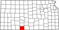
 郡のカンザス州内の位置
| |
 州のアメリカ合衆国内の位置
| |
| 設立 | 1867年2月26日 |
| 郡庁所在地 | コールドウォーター |
| 面積 - 総面積 - 陸 - 水 |
2,045 km2 (789.69 mi2) 2,042 km2 (788.298 mi2) 4 km2 (1.392 mi2), 0.18% |
| 人口 - (2010年) - 密度 |
1,891人 0.9人/km2 (2.4人/mi2) |
| 標準時 | 中部標準時: -6/-5 |
| ウェブサイト | comanchecounty |
コマンチ郡(英: Comanche County 標準略語:CM)は、アメリカ合衆国カンザス州の南部に位置する郡である。2010年国勢調査での人口は1,891人であり、2000年の1,967人から3.9%減少した[1]。郡庁所在地はコールドウォーター市(人口828人[2])であり[3]、同郡で人口最大の都市でもある。
法と政府
[編集]コマンチ郡はアルコールを禁じる、すなわち「ドライ」の郡だったが、1986年にカンザス州憲法が修正され、住民は2010年の投票で個人が嗜むアルコール飲料の販売を承認した。食料販売量制限は付かなかった[4]。
地理
[編集]アメリカ合衆国国勢調査局に拠れば、郡域全面積は789.69平方マイル (2,041.68 km2)であり、このうち陸地は788.298平方マイル (2,041.68 km2)、水域は1.392平方マイル (3.6 km2)で水域率は0.18%である[5]。
隣接する郡
[編集]- カイオワ郡 - 北
- バーバー郡 - 東
- ウッズ郡 (オクラホマ州) - 南
- ハーパー郡 (オクラホマ州) - 南西
- クラーク郡 - 西

|
クラーク郡 | カイオワ郡 | バーバー郡 | 
|
| クラーク郡 | バーバー郡 | |||
| ハーパー郡 (オクラホマ州) | ウッズ郡 (オクラホマ州) |
人口動態
[編集]| 人口推移 | |||
|---|---|---|---|
| 年 | 人口 | %± | |
| 1880 | 372 | [6] | — |
| 1890 | 2,549 | 585.2% | |
| 1900 | 1,619 | −36.5% | |
| 1910 | 3,281 | 102.7% | |
| 1920 | 5,302 | 61.6% | |
| 1930 | 5,238 | −1.2% | |
| 1940 | 4,412 | −15.8% | |
| 1950 | 3,888 | −11.9% | |
| 1960 | 3,271 | −15.9% | |
| 1970 | 2,702 | −17.4% | |
| 1980 | 2,554 | −5.5% | |
| 1990 | 2,313 | −9.4% | |
| 2000 | 1,967 | −15.0% | |
| 2010 | 1,891 | −3.9% | |
| 2013(推計) | 1,955 | 3.4% | |
| U.S. Decennial Census[7] 1790-1960[8] 1900-1990[9] 1990-2000[10] 2010-2013[1] | |||

|
基礎データ
人種別人口構成
年齢別人口構成
|
世帯と家族(対世帯数)
収入[編集]収入と家計 |
都市と町
[編集]法人化された都市
[編集]都市名の後の数字は2010年国勢調査での人口を示す[11]。
- コールドウォーター, 828 - 郡庁所在地
- プロテクション, 514
- ウィリモア, 53
その他の町
[編集]- バターミルク
郡区
[編集]コマンチ郡は4郡区に分けられている。どの都市も「政治的に独立」(英: governmentally independent)と見なされず、下記郡区の数字に含まれている。下表で「人口中心」は最大都市であり、特に大きな数字でなければ、郡区の人口に含まれるものである。
| 郡区 | FIPSコード | 人口中心 | 人口 | 人口密度 /km2 (/sq mi) |
陸地面積 km2 (sq mi) |
水域 km2 (sq mi) |
水域率(%) | 座標 |
|---|---|---|---|---|---|---|---|---|
| アビラ | 03525 | 58 | 0 (0) | 309 (119) | 0 (0) | 0.15% | 北緯37度5分14秒 西経99度17分20秒 / 北緯37.08722度 西経99.28889度 | |
| コールドウォーター | 14725 | コールドウォーター | 1,086 | 1 (3) | 1,099 (424) | 2 (1) | 0.17% | 北緯37度16分6秒 西経99度18分5秒 / 北緯37.26833度 西経99.30139度 |
| パウェル | 57325 | 89 | 0 (1) | 186 (72) | 0 (0) | 0.03% | 北緯37度20分36秒 西経99度8分37秒 / 北緯37.34333度 西経99.14361度 | |
| プロテクション | 57875 | プロテクション | 734 | 2 (4) | 448 (173) | 1 (0) | 0.28% | 北緯37度12分20秒 西経99度29分16秒 / 北緯37.20556度 西経99.48778度 |
| Sources: “Census 2000 U.S. Gazetteer Files”. U.S. Census Bureau, Geography Division. 2012年4月1日閲覧。 | ||||||||
教育
[編集]統一教育学区
[編集]脚注
[編集]- ^ a b Quickfacts.census.gov - Comanche County - accessed 2011-12-06.
- ^ American FactFinder - Coldwater, Kansas - accessed 2011-12-06.
- ^ Find a County, National Association of Counties 2011年6月7日閲覧。
- ^ “2012 Kansas Liquor by the Drink Map (Wet and Dry Counties)”. Property Valuation Division, GIS Section, Kansas Department of Revenue (2012年12月31日). 2015年3月12日閲覧。
- ^ “2014 U.S. Gazetteer Files: Counties”. U.S. Census Bureau. 2015年3月12日閲覧。
- ^ The 1880 census population includes areas that were organized into Kiowa County in 1886.
- ^ “U.S. Decennial Census”. United States Census Bureau. 2014年7月22日閲覧。
- ^ “Historical Census Browser”. University of Virginia Library. 2014年7月22日閲覧。
- ^ “Population of Counties by Decennial Census: 1900 to 1990”. United States Census Bureau. 2014年7月22日閲覧。
- ^ “Census 2000 PHC-T-4. Ranking Tables for Counties: 1990 and 2000”. United States Census Bureau. 2014年7月22日閲覧。
- ^ American FactFinder - Kansas - accessed 2011-12-06.
参考文献
[編集]- History of the State of Kansas; William G. Cutler; A.T. Andreas Publisher; 1883. (Online HTML eBook)
- Kansas : A Cyclopedia of State History, Embracing Events, Institutions, Industries, Counties, Cities, Towns, Prominent Persons, Etc; 3 Volumes; Frank W. Blackmar; Standard Publishing Co; 944 / 955 / 824 pages; 1912. (Volume1 - Download 54MB PDF eBook),(Volume2 - Download 53MB PDF eBook), (Volume3 - Download 33MB PDF eBook)
外部リンク
[編集]- Official sites
- Comanche County - 公式サイト
- Additional information
- Maps
- Comanche County Maps: Current, Historic, KDOT
- Kansas Highway Maps: Current, Historic, KDOT
- Kansas Railroad Maps: Current, 1996, 1915, KDOT and Kansas Historical Society
| 全般 | |
|---|---|
| 国立図書館 | |
| その他 | |
Text is available under the CC BY-SA 4.0 license; additional terms may apply.
Images, videos and audio are available under their respective licenses.
