コテリヌイ島
この記事は検証可能な参考文献や出典が全く示されていないか、不十分です。 出典を追加して記事の信頼性向上にご協力ください。(このテンプレートの使い方)出典検索?: "コテリヌイ島" – ニュース · 書籍 · スカラー · CiNii · J-STAGE · NDL · dlib.jp · ジャパンサーチ · TWL (2020年3月)


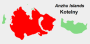
コテリヌイ島(コテリヌイとう、Котельный, Kotelny)は、東シベリア海上のノヴォシビルスク諸島のアンジュー諸島を構成する島の一つ。本来は別の島である東側のファデエフスキイ島 (Фаддеевский, Faddeyevsky) と、あいだにできた砂州ゼムリャ・ブンゲ(ロシア語: Земля Бунге) と呼ばれる砂地の堆積によって繋がっている。ブンゲ・ゼムリャはときに海面下に沈むことがあるが、全体で一つの島とすると、世界で47番目に大きな島である(面積 23,165km2)。
コテリヌイ島は岩がちであり、最高点はマラカチン・タスと呼ばれる山で374m。マラカチン・タスはノヴォシビルスク諸島の最高点でもある。
地理
[編集]構成する島
[編集]- コテリヌイ島の区分
-
 アンジュー諸島におけるコテリヌイ島の位置。
 -
 アンジュー諸島におけるゼムリャ・ブンゲの位置。
 -
 アンジュー諸島におけるファデエフスキイ島の位置。


気候
[編集]| Kotelny Islandの気候 | |||||||||||||
|---|---|---|---|---|---|---|---|---|---|---|---|---|---|
| 月 | 1月 | 2月 | 3月 | 4月 | 5月 | 6月 | 7月 | 8月 | 9月 | 10月 | 11月 | 12月 | 年 |
| 最高気温記録 °C (°F) | −7.2 (19) |
−3.3 (26.1) |
−4.8 (23.4) |
1.2 (34.2) |
6.2 (43.2) |
22.4 (72.3) |
25.1 (77.2) |
20.2 (68.4) |
11.8 (53.2) |
1.8 (35.2) |
−2.5 (27.5) |
−3.1 (26.4) |
25.1 (77.2) |
| 平均最高気温 °C (°F) | −26.1 (−15) |
−26.4 (−15.5) |
−24.2 (−11.6) |
−16.9 (1.6) |
−6.2 (20.8) |
1.4 (34.5) |
5.7 (42.3) |
4.3 (39.7) |
0.3 (32.5) |
−8.1 (17.4) |
−18.2 (−0.8) |
−23.8 (−10.8) |
−11.5 (11.3) |
| 日平均気温 °C (°F) | −29.3 (−20.7) |
−29.7 (−21.5) |
−27.5 (−17.5) |
−20.3 (−4.5) |
−8.6 (16.5) |
−0.4 (31.3) |
2.9 (37.2) |
2.1 (35.8) |
−1.2 (29.8) |
−10.7 (12.7) |
−21.5 (−6.7) |
−27.0 (−16.6) |
−14.3 (6.3) |
| 平均最低気温 °C (°F) | −32.6 (−26.7) |
−32.9 (−27.2) |
−30.9 (−23.6) |
−24.2 (−11.6) |
−11.4 (11.5) |
−2.1 (28.2) |
0.6 (33.1) |
0.2 (32.4) |
−3.0 (26.6) |
−13.7 (7.3) |
−24.8 (−12.6) |
−30.3 (−22.5) |
−17.1 (1.2) |
| 最低気温記録 °C (°F) | −44.9 (−48.8) |
−49.9 (−57.8) |
−46.1 (−51) |
−46.2 (−51.2) |
−28.6 (−19.5) |
−14.9 (5.2) |
−6.0 (21.2) |
−9.2 (15.4) |
−18.6 (−1.5) |
−40.2 (−40.4) |
−40.2 (−40.4) |
−45.0 (−49) |
−49.9 (−57.8) |
| 降水量 mm (inch) | 7 (0.28) |
5 (0.2) |
6 (0.24) |
8 (0.31) |
9 (0.35) |
17 (0.67) |
26 (1.02) |
23 (0.91) |
23 (0.91) |
16 (0.63) |
7 (0.28) |
7 (0.28) |
154 (6.06) |
| 平均降雨日数 | 0 | 0 | 0 | 0.1 | 1 | 8 | 15 | 15 | 9 | 0.4 | 0 | 0 | 49 |
| 平均降雪日数 | 15 | 16 | 16 | 15 | 22 | 16 | 8 | 11 | 22 | 26 | 18 | 16 | 201 |
| % 湿度 | 82 | 82 | 82 | 83 | 87 | 90 | 90 | 91 | 90 | 88 | 84 | 82 | 86 |
| 平均月間日照時間 | 0 | 7 | 147 | 283 | 197 | 178 | 168 | 100 | 44 | 14 | 0 | 0 | 1,138 |
| 出典1:Pogoda.ru.net[1] | |||||||||||||
| 出典2:NOAA (sun 1961–1990)[2] | |||||||||||||
脚注
[編集]- ^ “Weather and Climate-The Climate of Kotelny Island” (ロシア語). Weather and Climate (Погода и климат). 27 February 2016閲覧。
- ^ “Kotel'nyj Island (Kotelny Island) Climate Normals 1961–1990”. National Oceanic and Atmospheric Administration. 27 February 2016閲覧。
Text is available under the CC BY-SA 4.0 license; additional terms may apply.
Images, videos and audio are available under their respective licenses.
Cover photo is available under {{::mainImage.info.license.name || 'Unknown'}} license.
Cover photo is available under {{::mainImage.info.license.name || 'Unknown'}} license.
Credit:
(see original file).
