ガルザ郡 (テキサス州)
| テキサス州ガルザ郡 | |
|---|---|
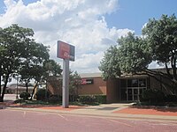
 ポスト市にあるガルザ郡庁舎
| |
 郡のテキサス州内の位置
| |
 州のアメリカ合衆国内の位置
| |
| 設立 | 1876年 |
| 郡庁所在地 | ポスト |
| 面積 - 総面積 - 陸 - 水 |
2,321 km2 (896 mi2) 2,318 km2 (895 mi2) 3 km2 (1 mi2), 0.07% |
| 人口 - (2010年) - 密度 |
6,461人 2人/km2 (5人/mi2) |
| 標準時 | 中部: UTC-6/-5 |
| ウェブサイト | www |
ガルザ郡(ガルザぐん、英: Garza County)は、アメリカ合衆国テキサス州の北部に位置する郡である。2010年国勢調査での人口は6,461人であり、2000年の4,872人から32.6%増加した[1]。郡庁所在地はポスト市(人口5,376人[2])であり[3]、同郡で人口最大の町でもある。ガルザ郡は1876年に設立され、郡名は、当時はベア郡の初期開拓者ガルザ家にちなんで名付けられた。
ガルザ郡の指導的な市民として2011年に亡くなったジャイルズ・マクラリーがいた。牧場主、石油開発者、投資家、美術品収集家であり、そのOS牧場博物館は、郡庁所在地のポスト市で観光地になっている。ポスト市は観光業を育てるために広範な努力を行ってきた。
年譜
[編集]

- 紀元前2000年 – インディアンが最初の住人だった。後にカイオワ族やコマンチ族が住んだ[4]
- 1875年、フォートワースのW・C・ヤングとイリノイ州のアイルランド系アメリカ人ベン・ガルブレイスがガルザ郡北西部にカリーコム牧場を設立した[5]
- 1876年、ガルザ郡がベア郡から分かれて設立され、郡名はベア郡の著名一族だったホセ・アントリオ・デ・ラ・ガルザに因んで名付けられた[6]
- 1880年、国勢調査による人口は36人だった[4]
- 1882年、スクエア・アンド・コンパス牧場がネイブ・アンド・マコード牛会社により運営を始められた。2年後に初めて有刺鉄線の柵を設けた[7]
- 1884年、ケンタッキー州レキシントン出身のアンドリュー・J・ロングとフランク・M・ロング兄弟によってOS牧場が設立された[8]
- 1900年、郡の人口は185人だった[4]
- 1907年、シリアルの王様チャールズ・ウアィリアム・ポストによってユートピアの試みとしてポストの町が造られ、ポストの名前をつけた[4][9]
- 1909年-1913年、ポストがコットン・ジンとコットン・ミルを作り、 人工降雨で農業生産を改良しようとした。このときキャップロック断崖の縁にそって凧と塔から爆薬を大量に使うこともあった[4][10]
- 1926年、郡内で石油が発見された[4][11]
- 1934年、考古学者が前史時代のマンモスの牙、長さ16フィート (4.9 m) のものを発見した[4]
- 1957年、ポスト市のエメット・シェドによって、 カウヘッド・メサで前史時代のインディアンの遺跡が記録された[12]
- 1960年-1965年、サウスプレーンズ考古学協会がカウヘッド・メサを発掘し、紀元前2000年のものとされる人工物を見つけた[12]
- 1980年、郡内の重要な産業は、農業、石油とガスの掘削、および繊維工場だった[4]
地理
[編集]アメリカ合衆国国勢調査局に拠れば、郡域全面積は896平方マイル (2,320.6 km2)であり、このうち陸地895平方マイル (2,318.0 km2)、水域は1平方マイル (2.6 km2)で水域率は0.07%である[13]。

主要高規格道路
[編集] アメリカ国道84号線
 アメリカ国道380号線
 テキサス州道207号線
 農場市場直結道路669号線
隣接する郡
[編集]
|
クロスビー郡 | 
| ||
| リン郡 | ケント郡 | |||
| ボーデン郡 | スカリー郡 |
人口動態
[編集]| 人口推移 | |||
|---|---|---|---|
| 年 | 人口 | %± | |
| 1880 | 36 | — | |
| 1890 | 14 | −61.1% | |
| 1900 | 185 | 1,221.4% | |
| 1910 | 1,995 | 978.4% | |
| 1920 | 4,253 | 113.2% | |
| 1930 | 5,586 | 31.3% | |
| 1940 | 5,678 | 1.6% | |
| 1950 | 6,281 | 10.6% | |
| 1960 | 6,611 | 5.3% | |
| 1970 | 5,289 | −20.0% | |
| 1980 | 5,336 | 0.9% | |
| 1990 | 5,143 | −3.6% | |
| 2000 | 4,872 | −5.3% | |
| 2010 | 6,461 | 32.6% | |
Texas Almanac: 1850-2010[15] | |||
|
基礎データ
人種別人口構成
年齢別人口構成
|
世帯と家族(対世帯数)
収入[編集]収入と家計 |
都市と町
[編集]- クローズシティ
- ポスト - 郡庁所在地
- ジャスティスバーグ
- サウスランド
脚注
[編集]- ^ Quickfacts.census.gov - Garza County - accessed 2011-12-06.
- ^ Quickfacts.census.gov - Post, Texas - accessed 2011-12-06.
- ^ Find a County, National Association of Counties 2011年6月7日閲覧。
- ^ a b c d e f g h Leffler, John. “Garza County, Texas”. Handbook of Texas Online. Texas State Historical Association. 17 December 2010閲覧。
- ^ Holden, William Curry. “Curry Comb Ranch”. Handbook of Texas Online. Texas State Historical Association. 17 December 2010閲覧。
- ^ Orozco, Cynthia E. “José Antonio de la Garza”. Handbook of Texas Online. Texas State Historical Association. 17 December 2010閲覧。
- ^ Holden, William Curry. “Square and Compass Ranch”. Handbook of Texas Online. Texas State Historical Association. 17 December 2010閲覧。
- ^ Woolley, Bryan (2004). “Pack Rat”. Texas Road Trip. Texas Christian University Press. pp. 25–36. ISBN 978-0-87565-291-7
- ^ “Post, Texas”. Texas Escapes. Texas Escapes - Blueprints For Travel, LLC. 17 December 2010閲覧。
- ^ Pearce, William M. “Charles William Post”. Handbook of Texas Online. Texas State Historical Association. 17 December 2010閲覧。
- ^ “Alumni Notes”. The Alcade: 52. (1985-09).
- ^ a b Howard, Margaret Ann. “Cowhead Mesa”. Handbook of Texas Online. Texas State Historical Association. 17 December 2010閲覧。
- ^ “Census 2000 U.S. Gazetteer Files: Counties”. United States Census. 2011年2月13日閲覧。
- ^ U.S. Decennial Census
- ^ Texas Almanac: County Population History 1850-2010
外部リンク
[編集]- Garza County government's website - 公式サイト
- Garza County from the Handbook of Texas Online
座標: 北緯33度11分 西経101度18分 / 北緯33.18度 西経101.30度
| 関連項目 | |
|---|---|
| 地域圏 | |
| 都市圏 | |
| その他の主な自治体 (人口10万人以上) | |
| 郡 | テキサス州の郡一覧を参照 |
|
| |
| 全般 | |
|---|---|
| 国立図書館 | |
| その他 | |
Text is available under the CC BY-SA 4.0 license; additional terms may apply.
Images, videos and audio are available under their respective licenses.
