For faster navigation, this Iframe is preloading the Wikiwand page for エルメラ県.

エルメラ県

エルメラ県

Ermera
エルメラ県の旗
エルメラ県の位置
エルメラ県の位置
南緯8度50分00秒 東経125度23分00秒 / 南緯8.83333度 東経125.38333度 / -8.83333; 125.38333
東ティモールの旗 東ティモール
地方 マリアナ地方
エルメラ県
地区 アトサベ地区、エルメラ地区、ハトリア地区、レテフォホ地区、ラリアコ地区
県都 グレノ
面積
 • 合計 746 km2
人口
(2008年)[1]
 • 合計 118,671人
 • 密度 159.1人/km2
等時帯 UTC+9

エルメラ県テトゥン語:Ermera)は、東ティモールの県のひとつ。同国の西部に位置する。746 km2に2004年の推計で11万8671人が暮らす[1]。県都は首都ディリから南西へ30kmほど行ったところにあるグレノ。ヴィラ・エルメラの名でも知られるエルメラ市は、首都から同じ道を58km進んだところにある。

国内に二つある内陸県のひとつ(もう一方はアイレウ県)で、北でリキシャ県、北東でディリ県、東でアイレウ県、南東でアイナロ県、西でボボナロ県とそれぞれ接する。

ポルトガル領ティモール時代から同様の組織が存在していた。アトサベ、エルメラ、ハトリア、レテフォホ、ラリアコの五地区から成る。
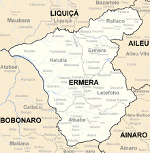
県内の地区
県内の都市

脚注

[編集]
{{bottomLinkPreText}} {{bottomLinkText}}
エルメラ県
Listen to this article

This browser is not supported by Wikiwand :(
Wikiwand requires a browser with modern capabilities in order to provide you with the best reading experience.
Please download and use one of the following browsers:

This article was just edited, click to reload
This article has been deleted on Wikipedia (Why?)

Back to homepage

Please click Add in the dialog above
Please click Allow in the top-left corner,
then click Install Now in the dialog
Please click Open in the download dialog,
then click Install
Please click the "Downloads" icon in the Safari toolbar, open the first download in the list,
then click Install
{{::$root.activation.text}}

Install Wikiwand

Install on Chrome Install on Firefox
Don't forget to rate us

Tell your friends about Wikiwand!

Gmail Facebook Twitter Link

Enjoying Wikiwand?

Tell your friends and spread the love:
Share on Gmail Share on Facebook Share on Twitter Share on Buffer

Our magic isn't perfect

You can help our automatic cover photo selection by reporting an unsuitable photo.

This photo is visually disturbing This photo is not a good choice

Thank you for helping!


Your input will affect cover photo selection, along with input from other users.

X

Get ready for Wikiwand 2.0 🎉! the new version arrives on September 1st! Don't want to wait?