For faster navigation, this Iframe is preloading the Wikiwand page for エアー半島.

エアー半島

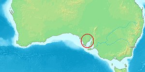
エアー半島の位置

エアー半島(Eyre Peninsula)とは、オーストラリア南オーストラリア州の南西部に位置する逆三角形の形をした半島である。東にはスペンサー湾、西にはグレートオーストラリア湾、北にはゴーラー山脈があり、南には南極海が広がっている。エアー半島の名は、1839年から1841年にかけてこの地を探検したエドワード・ジョン・エアから取った名前である。1801年から1802年にかけて、マシュー・フリンダース海岸線を調査した。また、ニコラ・ボーダンも同時期に調査した。

主な都市

[編集]

各都市は、フリンダーズハイウェイやエアーハイウェイなどで結ばれている。

主要産業

[編集]
  • 穀物
  • 牛・羊・豚
  • マグロ養殖(日本からも多くの漁業関係者が来ている)

国立公園

[編集]

半島内には、次の3つの国立公園がある。

  • ゴーラー山脈国立公園,Gawler Ranges(半島北部)
  • リンカーン国立公園,Lincoln(半島南東部)
  • コフィン・ベイ国立公園,Coffin Bay(半島南西部)

山火事

[編集]

2005年1月に、半島南部で、山火事が発生し、9人が死亡した。この山火事は、過去20年間でオーストラリア国内で最悪の火事だったといわれた。

外部リンク

[編集]
{{bottomLinkPreText}} {{bottomLinkText}}
エアー半島
Listen to this article

This browser is not supported by Wikiwand :(
Wikiwand requires a browser with modern capabilities in order to provide you with the best reading experience.
Please download and use one of the following browsers:

This article was just edited, click to reload
This article has been deleted on Wikipedia (Why?)

Back to homepage

Please click Add in the dialog above
Please click Allow in the top-left corner,
then click Install Now in the dialog
Please click Open in the download dialog,
then click Install
Please click the "Downloads" icon in the Safari toolbar, open the first download in the list,
then click Install
{{::$root.activation.text}}

Install Wikiwand

Install on Chrome Install on Firefox
Don't forget to rate us

Tell your friends about Wikiwand!

Gmail Facebook Twitter Link

Enjoying Wikiwand?

Tell your friends and spread the love:
Share on Gmail Share on Facebook Share on Twitter Share on Buffer

Our magic isn't perfect

You can help our automatic cover photo selection by reporting an unsuitable photo.

This photo is visually disturbing This photo is not a good choice

Thank you for helping!


Your input will affect cover photo selection, along with input from other users.

X

Get ready for Wikiwand 2.0 🎉! the new version arrives on September 1st! Don't want to wait?