ウナラスカ
| ウナラスカ市 Unalaska | |
|---|---|
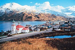
 ウナラスカ俯瞰図 | |
| 位置 | |
 アラスカ州ウナラスカの位置 | |
| 座標 : 北緯53度53分20秒 西経166度31分38秒 / 北緯53.88889度 西経166.52722度 | |
| 行政 | |
| 国 | |
| 州 | アラスカ州 |
| 国勢調査地域 | アリューシャンズ・ウェスト国勢調査地域 |
| 市 | ウナラスカ市 |
| 地理 | |
| 面積 | |
| 市域 | 549.9 km2 (212.3 mi2) |
| 陸上 | 287.5 km2 (111.0 mi2) |
| 水面 | 262.4 km2 (101.3 mi2) |
| 水面面積比率 | 47.72% |
| 標高 | 4 m (13 ft) |
| 人口 | |
| 人口 | (2007年現在) |
| 市域 | 3,836人 |
| 人口密度 | 14.9人/km2(38.6人/mi2) |
| その他 | |
| 等時帯 | AKST (UTC-9) |
| 夏時間 | AKDT (UTC-8) |
ウナラスカ(Unalaska)は、北太平洋アリューシャン列島のフォックス諸島にある都市。ウナラスカ島と隣接するアマクナック島にまたがって存在する。アメリカ合衆国アラスカ州に所属する。なお、港湾地区はダッチハーバーとして知られている。
地理
[編集]市域総面積は549.9km2(212.1mi2)である。このうち287.5km2(111.0mi2)が陸地、262.4km2(101.3mi2)が水域である。その内、総面積の47.72%が水域である。
気候
[編集]アリューシャン列島と同様に亜寒帯海洋性気候にあたる。 夏は、アラスカ南東部(シトカ)より低い(2.8℃)程度であるが、冬の気温はほぼ同じ。
| アラスカ州ウナラスカダッチハーバーの気候 | |||||||||||||
|---|---|---|---|---|---|---|---|---|---|---|---|---|---|
| 月 | 1月 | 2月 | 3月 | 4月 | 5月 | 6月 | 7月 | 8月 | 9月 | 10月 | 11月 | 12月 | 年 |
| 最高気温記録 °F (°C) | 58 (14) |
54 (12) |
61 (16) |
58 (14) |
60 (16) |
73 (23) |
75 (24) |
81 (27) |
74 (23) |
65 (18) |
57 (14) |
59 (15) |
81 (27) |
| 平均最高気温 °F (°C) | 36.8 (2.7) |
37.3 (2.9) |
38.6 (3.7) |
40.9 (4.9) |
46.1 (7.8) |
51.7 (10.9) |
56.8 (13.8) |
58.9 (14.9) |
54.0 (12.2) |
47.3 (8.5) |
42.6 (5.9) |
39.0 (3.9) |
45.8 (7.7) |
| 平均最低気温 °F (°C) | 28.1 (−2.2) |
27.6 (−2.4) |
28.3 (−2.1) |
31.4 (−0.3) |
36.7 (2.6) |
41.9 (5.5) |
46.0 (7.8) |
47.7 (8.7) |
43.5 (6.4) |
37.2 (2.9) |
32.1 (0.1) |
30.3 (−0.9) |
35.9 (2.2) |
| 最低気温記録 °F (°C) | −8 (−22) |
0 (−18) |
2 (−17) |
−5 (−21) |
15 (−9) |
30 (−1) |
21 (−6) |
30 (−1) |
19 (−7) |
2 (−17) |
8 (−13) |
5 (−15) |
−8 (−22) |
| 降水量 inch (mm) | 7.28 (184.9) |
6.35 (161.3) |
5.40 (137.2) |
3.46 (87.9) |
3.98 (101.1) |
2.48 (63) |
2.19 (55.6) |
2.69 (68.3) |
5.21 (132.3) |
7.17 (182.1) |
6.76 (171.7) |
7.89 (200.4) |
60.86 (1,545.8) |
| 降雪量 inch (cm) | 23.8 (60.5) |
20.4 (51.8) |
16.5 (41.9) |
6.6 (16.8) |
0.2 (0.5) |
0 (0) |
0 (0) |
0 (0) |
0 (0) |
0.5 (1.3) |
6.4 (16.3) |
17.1 (43.4) |
91.5 (232.5) |
| 平均降水日数 (≥0.01 inch) | 21 | 20 | 20 | 17 | 17 | 14 | 13 | 14 | 18 | 23 | 23 | 23 | 223 |
| 出典:WRCC[2] | |||||||||||||
人口動勢
[編集]2000年の統計によると人口は4,283人。世帯数は834で476家族が市街地に暮らしている。人口密度は14.9/km2(38.6/mi2)。
対外関係
[編集]姉妹都市・提携都市
[編集]関連項目
[編集]- アラスカのインノケンティ - 最初の任地がウナラスカであった
脚注
[編集]- ^ 奥野充他. “アリューシャン列島、ウナラスカ島のダッチハーバー周辺の泥炭層の層序と年代”. 福岡大学. 2018年4月8日閲覧。
- ^ “DUTCH HARBOR, ALASKA (502587)”. Western Regional Climate Centre. 2011年11月5日閲覧。
外部リンク
[編集]- ウナラスカ市 公式サイト(英語)
- UNALASKA アラスカの観光サイト(英語)
- Aerial of Dutch Harbor, Unalaska Island
| 関連項目 | |
|---|---|
| 地域圏 | |
| 主な都市 | |
| 郡 | |
| 国勢調査地域 |
|
|
| |
| 全般 | |
|---|---|
| 国立図書館 | |
| 地理 | |
| その他 | |
Text is available under the CC BY-SA 4.0 license; additional terms may apply.
Images, videos and audio are available under their respective licenses.
