ウェブスター郡 (ウェストバージニア州)
| ウェストバージニア州ウェブスター郡 | |
|---|---|
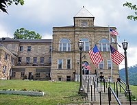
 ウェブスタースプリングス町にあるウェブスター郡庁舎、2007年撮影
| |
 郡のウェストバージニア州内の位置
| |
 州のアメリカ合衆国内の位置
| |
| 設立 | 1860年 |
| 郡庁所在地 | ウェブスタースプリングス |
| 面積 - 総面積 - 陸 - 水 |
1,440 km2 (556 mi2) 1,435 km2 (554 mi2) 5 km2 (2 mi2), 0.03% |
| 人口 - (2010年) - 密度 |
9,154人 6人/km2 (16人/mi2) |
| 標準時 | 東部: UTC-5/-4 |
| ウェブサイト | www |
ウェブスター郡(英: Webster County)は、アメリカ合衆国ウェストバージニア州の中央部に位置する郡である。2010年国勢調査での人口は9,154人であり、2000年の9,719人から5.8%減少した[1]。郡庁所在地はウェブスタースプリングス町(人口776人[2])であり、同郡で人口最大の町でもある。ウェブスター郡は1860年に設立され、郡名は19世紀の政治家ダニエル・ウェブスターに因んで名付けられた[3]。
地理
[編集]アメリカ合衆国国勢調査局に拠れば、郡域全面積は556平方マイル (1,440 km2)であり、このうち陸地554平方マイル (1,435 km2)、水域は2平方マイル (5 km2)で水域率は0.03%である[4]。
主要高規格道路
[編集]隣接する郡
[編集]
|
ルイス郡、アップシャー郡 | 
| ||
| ブラクストン郡 | ランドルフ郡 | |||
| ニコラス郡 | グリーンブライア郡 | ポカホンタス郡 |
国立保護地域
[編集]
- モノンガヘラ国立の森(部分)
人口動態
[編集]| 人口推移 | |||
|---|---|---|---|
| 年 | 人口 | %± | |
| 1860 | 1,555 | — | |
| 1870 | 1,730 | 11.3% | |
| 1880 | 3,207 | 85.4% | |
| 1890 | 4,783 | 49.1% | |
| 1900 | 8,862 | 85.3% | |
| 1910 | 9,680 | 9.2% | |
| 1920 | 11,562 | 19.4% | |
| 1930 | 14,216 | 23.0% | |
| 1940 | 18,080 | 27.2% | |
| 1950 | 17,888 | −1.1% | |
| 1960 | 13,719 | −23.3% | |
| 1970 | 9,809 | −28.5% | |
| 1980 | 12,245 | 24.8% | |
| 1990 | 10,729 | −12.4% | |
| 2000 | 9,719 | −9.4% | |
| 2010 | 9,154 | −5.8% | |
|
基礎データ
人種別人口構成
|
年齢別人口構成
世帯と家族(対世帯数)
|
収入[編集]収入と家計 |
都市と町
[編集]法人化町
[編集]- カムデン・オン・ゴーリー
- コーウェン
- ウェブスタースプリングス、公式にはアディソン町 - 郡庁所在地
次のリストは郡内の未編入町であるが、これで全てではない。
未編入の町
[編集]
|
|
政治
[編集]ウェブスター郡は、1972年を除き、1863年以降のアメリカ大統領選挙は全て民主党候補を支持してきた。1972年は共和党のリチャード・ニクソンが全国的に大勝した時であるが、ウェブスター郡の場合は民主党のジョージ・マクガヴァンとの差は1.0%に過ぎなかった。2012年の選挙では、共和党のミット・ロムニーが民主党のバラク・オバマに28%の大差を付けてウェブスター郡を制した[5]。
脚注
[編集]- ^ Quickfacts.census.gov - Webster County - accessed 2011-12-06.
- ^ American FactFinder - Webster Springs, West Virginia - accessed 2011-12-06.
- ^ http://www.wvculture.org/history/counties/webster.html
- ^ “Census 2010 U.S. Gazetteer Files: Counties”. United States Census. 2013年4月13日閲覧。
- ^ CNN 2012 Election site
外部リンク
[編集]- Official website - 公式サイト
- Official website of the Webster County Woodchopping Festival
- Two-Lane Livin' Magazine
座標: 北緯38度29分 西経80度26分 / 北緯38.49度 西経80.43度
| 全般 | |
|---|---|
| 国立図書館 | |
| 地理 | |
| その他 | |
Text is available under the CC BY-SA 4.0 license; additional terms may apply.
Images, videos and audio are available under their respective licenses.
