For faster navigation, this Iframe is preloading the Wikiwand page for イランの地震一覧.

イランの地震一覧

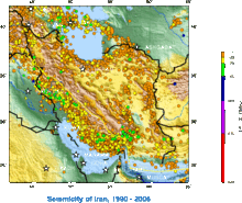
1990年から2006年までにイランで発生した主な地震(アメリカ地質調査所のデータより)

イランの地震一覧(イランのじしんいちらん)では、イラン・イスラム共和国で起きた大きな地震を一覧で示す。イランは、世界的にも地震発生が最も多い国の1つであり[1] 、幾つもの大きな断層が走り国内の90%以上を覆っている[2]。これによって、イランにはたびたび地震が発生し、破壊的となる。

地質と歴史

[編集]

イランの南縁部国境線の地下は、アラビアプレートユーラシアプレートという2枚の巨大なプレート境界線にあたるため、プレート境界型の大きな地震が頻発することになる[3][4][5]イラン高原は、活動的な褶曲断層、または火山の噴火といった、プレート・テクトニクスで説明されるような地殻の動きによる地震の被害を受けやすい地域である。このことは、長い地震災害の歴史によってよく知られている。これらの地震は、数千人規模での死者を出すだけでなく、価値ある天然資源を失わせる[6]。1900年以降、イランでは少なくとも126,000人の命が地震によって失われた[6]

一覧

[編集]

21世紀

[編集]
年月日 時間 震央 マグニチュード 死亡者数 位置座標 名称
2014年8月18日 07:02[7] ムールムーリー 6.2 - 北緯32度42分 東経47度36分 / 北緯32.7度 東経47.6度 / 32.7; 47.6
2013年5月11日 06:38:09[7] ゴハラーン 6.2 - 北緯26度31分 東経57度46分 / 北緯26.52度 東経57.76度 / 26.52; 57.76
2013年4月16日 10:44:13 スィースターン・バルーチェスターン州 7.8 35 北緯28度04分 東経62度05分 / 北緯28.06度 東経62.08度 / 28.06; 62.08 イラン地震 (2013年4月16日)
2013年4月9日 16:22:50 ブーシェフル 6.3 60人以上 北緯28度30分 東経51度35分 / 北緯28.50度 東経51.59度 / 28.50; 51.59 イラン地震 (2013年4月9日)
2012年8月11日 12:23:18 タブリーズ 6.4 and 6.3 306 北緯38度19分26秒 東経46度45分32秒 / 北緯38.324度 東経46.759度 / 38.324; 46.759 イラン北西部地震
2011年6月15日 01:05:30 カフヌージ 5.3 2 北緯27度58分34秒 東経57度34分26秒 / 北緯27.976度 東経57.574度 / 27.976; 57.574
2010年12月20日 22:12:01 ケルマーン州ファハラージ 6.5[8] 7 北緯38度16分23秒 東経48度17分30秒 / 北緯38.27306度 東経48.29167度 / 38.27306; 48.29167 イラン地震 (2010年12月)
2010年8月27日 23:56:34 ダームガーン 5.9 19 北緯26度44分34.8秒 東経55度49分40.8秒 / 北緯26.743000度 東経55.828000度 / 26.743000; 55.828000
2008年9月10日 11:00:34 ゲシュム島 6.1 7 北緯26度44分34.8秒 東経55度49分40.8秒 / 北緯26.743000度 東経55.828000度 / 26.743000; 55.828000
2006年3月31日 01:17:01 ロレスターン州ボルージェルド 6.1[9] 70人[9] 北緯33度34分51.6秒 東経48度47分38.4秒 / 北緯33.581000度 東経48.794000度 / 33.581000; 48.794000
2005年11月27日 10:22:19 ゲシュム島 6.0[10] 13人[10] 北緯26度47分2.4秒 東経55度50分49.2秒 / 北緯26.784000度 東経55.847000度 / 26.784000; 55.847000
2005年2月22日 02:25:22 ケルマーン州ザーランド 6.4[11] 602人以上[12] 北緯30度44分27.6秒 東経56度52分37.2秒 / 北緯30.741000度 東経56.877000度 / 30.741000; 56.877000
2004年5月28日 12:38:46 マーザンダラーン州 6.3[13] 35人以上[13] 北緯36度16分12秒 東経51度34分30秒 / 北緯36.27000度 東経51.57500度 / 36.27000; 51.57500
2003年12月26日 01:56:52 バム 6.6[14] 30,000人以上[14] 北緯29度0分14.4秒 東経58度20分13.2秒 / 北緯29.004000度 東経58.337000度 / 29.004000; 58.337000 バム地震
2002年6月22日 02:58:21 ガズヴィーン 6.5[15] 262人[2] 北緯35度40分8.4秒 東経48度55分58.8秒 / 北緯35.669000度 東経48.933000度 / 35.669000; 48.933000

20世紀

[編集]
年月日 時間 震央 マグニチュード 死亡者数 位置座標 名称
1998年3月14日 19:40:02 Golbaf 6.6 5 北緯30度9分 東経57度36分 / 北緯30.150度 東経57.600度 / 30.150; 57.600
1997年5月10日 07:57:29 ビールジャンド-Qaen 7.3 1,567人[16] 北緯33度49分12秒 東経59度48分0秒 / 北緯33.82000度 東経59.80000度 / 33.82000; 59.80000
1997年2月28日 en:Ardabil 6.0[17] - 北緯38度15分 東経48度17分 / 北緯38.250度 東経48.283度 / 38.250; 48.283
1990年6月20日 en:Manjil(-en:Rudbar) 7.4[18] 40,000人以上[18] 北緯37度0分 東経49度24分 / 北緯37.000度 東経49.400度 / 37.000; 49.400 イラン北西部ルードバール地震
1981年7月28日 Southern Iran 7.3[19] 1,500[19] 北緯30度0分 東経57度48分 / 北緯30.000度 東経57.800度 / 30.000; 57.800
1981年6月11日 Southern Iran 6.9[19] 3,000人[19] 北緯29度54分 東経57度42分 / 北緯29.900度 東経57.700度 / 29.900; 57.700
1978年9月16日 en:Tabas 7.8[19] 15,000人[19] 北緯33度12分 東経57度24分 / 北緯33.200度 東経57.400度 / 33.200; 57.400 タバス地震
1972年4月10日 7.1[19] 5,054人[19] 北緯28度24分 東経52度48分 / 北緯28.400度 東経52.800度 / 28.400; 52.800
1968年8月31日 Dasht-e-Bayaz 7.3[20] At least 7,000[20] 北緯33度54分0秒 東経59度1分12秒 / 北緯33.90000度 東経59.02000度 / 33.90000; 59.02000 ビヤズ地震
1965年2月10日 16:09 Bostanabad-e Bala 5.1 20人
1962年9月1日 Bou'in-Zahra 7.1[20] 12,225人[20] 北緯35度36分 東経49度54分 / 北緯35.600度 東経49.900度 / 35.600; 49.900 ボインザラ地震
1957年12月13日 Sahneh 7.1[20] 1,130人[20] 北緯34度21分0秒 東経47度40分12秒 / 北緯34.35000度 東経47.67000度 / 34.35000; 47.67000
1957年7月2日 マーザンダラーン州 7.1[20] 1,200人[20] 北緯36度8分24秒 東経52度42分0秒 / 北緯36.14000度 東経52.70000度 / 36.14000; 52.70000
1953年2月12日 Torud 6.5 970人
1947年8月5日 Pasni 7.3
1930年5月6日 en:Salmas 7.2[19] 2, 500人[19] 北緯38度9分 東経44度42分 / 北緯38.150度 東経44.700度 / 38.150; 44.700
1929年5月1日 Koppeh Dagh 7.4[19] 3,800人[19] 北緯37度51分 東経57度45分 / 北緯37.850度 東経57.750度 / 37.850; 57.750
1923年5月25日 Torbat-e Heydariyeh 5.7[19] 2,200人[19] 北緯33度24分 東経59度6分 / 北緯33.400度 東経59.100度 / 33.400; 59.100
1909年1月23日 Silakhor 7.3[20] 6,000人[20] 北緯33度24分 東経49度6分 / 北緯33.400度 東経49.100度 / 33.400; 49.100

19世紀以前

[編集]
年月日 震央 マグニチュード 死亡者数 位置座標
1755年6月7日 カーシャーン Unknown 40,000人 北緯33度59分 東経51度27分 / 北緯33.983度 東経51.450度 / 33.983; 51.450
1721年4月26日 タブリーズ M7.7 80,000人 北緯38度0分 東経46度3分 / 北緯38.000度 東経46.050度 / 38.000; 46.050
1727年11月18日 タブリーズ Unknown 77,000人 北緯38度5分 東経46度17分 / 北緯38.083度 東経46.283度 / 38.083; 46.283
893年3月23日 アルダビール Unknown 150,000人 北緯38度15分 東経48度17分 / 北緯38.250度 東経48.283度 / 38.250; 48.283
856年12月22日 ダームガーン Unknown 200,000人 北緯36度10分 東経54度21分 / 北緯36.167度 東経54.350度 / 36.167; 54.350

脚注

[編集]
  1. ^ “Help too late, say quake survivors”. CNN. (2002年6月24日). https://edition.cnn.com/2002/WORLD/meast/06/24/iran.anger/index.html 2010年12月21日閲覧。 
  2. ^ a b Preliminary Earthquake Reconnaissance Report on the June 22, 2002 Changureh (Avaj), Iran Earthquake”. International Institute of Earthquake Engineering and Seismology (2002年7月19日). 2008年12月30日閲覧。
  3. ^ 福島県防災情報2010年12月21日閲覧
  4. ^ 全日本地震防災推進協議会鹿児島支部 「地震のメカニズム」2010年12月21日閲覧
  5. ^ USGS "Earthquakes and Plate Tectonics"2010年12月21日閲覧
  6. ^ a b Manuel Berberian. “100 years; 126,000 deaths”. The Iranian. 2010年12月21日閲覧。
  7. ^ a b 現地時間
  8. ^ foxnews.com "Mapping Earthquake in Southeastern Iran"
  9. ^ a b Magnitude 6.1 - Western Iran”. United States Geological Survey (2008年7月16日). 2010年12月21日閲覧。
  10. ^ a b Magnitude 6.0 - Southern Iran”. United States Geological Survey (2008年7月16日). 2010年12月21日閲覧。
  11. ^ Earthquake Summary Poster”. United States Geological Survey (2008年7月16日). 2009年3月14日閲覧。
  12. ^ Magnitude 6.4 - Central Iran”. United States Geological Survey (2008年7月16日). 2010年12月21日閲覧。
  13. ^ a b Magnitude 6.3 - Northern Iran”. United States Geological Survey (2008年7月16日). 2010年12月21日閲覧。
  14. ^ a b Magnitude 6.6 - Southeastern Iran”. United States Geological Survey (2008年7月16日). 2010年12月21日閲覧。
  15. ^ Magnitude 6.5 - Western Iran”. United States Geological Survey (2003年11月13日). 2010年12月21日閲覧。
  16. ^ Magnitude 7.3 - Northern Iran 1997”. Earthquake Information for 1990. USGS (2004年4月22日). 2010年12月21日閲覧。
  17. ^ Significant Earthquakes of the World: 1997”. United States Geological Survey (2008年7月16日). 2010年12月21日閲覧。
  18. ^ a b Earthquake Information for 1990”. United States Geological Survey. 2010年12月21日閲覧。
  19. ^ a b c d e f g h i j k l m n Historic Worldwide Earthquakes”. United States Geological Survey (2009年1月29日). 2010年12月21日閲覧。
  20. ^ a b c d e f g h i j Earthquakes with 1,000 or More Deaths since 1900”. United States Geological Survey (2009年1月29日). 2010年12月21日閲覧。

参考文献

[編集]
この節の加筆が望まれています。

関連項目

[編集]

外部リンク

[編集]
{{bottomLinkPreText}} {{bottomLinkText}}
イランの地震一覧
Listen to this article

This browser is not supported by Wikiwand :(
Wikiwand requires a browser with modern capabilities in order to provide you with the best reading experience.
Please download and use one of the following browsers:

This article was just edited, click to reload
This article has been deleted on Wikipedia (Why?)

Back to homepage

Please click Add in the dialog above
Please click Allow in the top-left corner,
then click Install Now in the dialog
Please click Open in the download dialog,
then click Install
Please click the "Downloads" icon in the Safari toolbar, open the first download in the list,
then click Install
{{::$root.activation.text}}

Install Wikiwand

Install on Chrome Install on Firefox
Don't forget to rate us

Tell your friends about Wikiwand!

Gmail Facebook Twitter Link

Enjoying Wikiwand?

Tell your friends and spread the love:
Share on Gmail Share on Facebook Share on Twitter Share on Buffer

Our magic isn't perfect

You can help our automatic cover photo selection by reporting an unsuitable photo.

This photo is visually disturbing This photo is not a good choice

Thank you for helping!


Your input will affect cover photo selection, along with input from other users.

X

Get ready for Wikiwand 2.0 🎉! the new version arrives on September 1st! Don't want to wait?