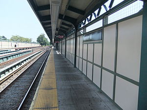
アベニューM駅
| |||||||
|---|---|---|---|---|---|---|---|
 | |||||||
| 駅情報 | |||||||
| 住所 |
Avenue M & East 16th Street Brooklyn, NY 11230 | ||||||
| 区 | ブルックリン | ||||||
| 地区 | ミッドウッド | ||||||
| 座標 | 北緯40度37分06秒 西経73度57分35秒 / 北緯40.618269度 西経73.95961度座標: 北緯40度37分06秒 西経73度57分35秒 / 北緯40.618269度 西経73.95961度 | ||||||
| ディビジョン | Bディビジョン(BMT) | ||||||
| 路線 | BMTブライトン線 | ||||||
| 運行系統 |
Q | ||||||
| 接続 |
| ||||||
| 構造 | 盛土駅 | ||||||
| ホーム数 | 相対式ホーム 2面 | ||||||
| 線路数 | 4線 | ||||||
| その他の情報 | |||||||
| 開業日 |
1878年(BF&CI) 1908年 (BRT) | ||||||
| 旧駅名/名称 |
エルム・アベニュー駅 Elm Avenue サウス・グリーンフィールド駅 South Greenfield | ||||||
| 利用状況 | |||||||
| 乗客数 (2017) | 1,828,941[1]人 | ||||||
| 順位 | 261位 | ||||||
| 次の停車駅 | |||||||
| 北側の隣駅 |
アベニューJ駅: Q | ||||||
| 南側の隣駅 |
キングス・ハイウェイ駅: Q | ||||||
| |||||||
アベニューM駅(英: Avenue M)はブルックリン区のアベニューMと東16丁目交差点西側に位置するニューヨーク市地下鉄BMTブライトン線の駅である。Q系統が終日停車する。
駅構造
[編集]配線図 | |||||||||||||||||||||||||||||||||||||||||||||||||||||||||||||||||||||||||||||||||||||||||||||
|---|---|---|---|---|---|---|---|---|---|---|---|---|---|---|---|---|---|---|---|---|---|---|---|---|---|---|---|---|---|---|---|---|---|---|---|---|---|---|---|---|---|---|---|---|---|---|---|---|---|---|---|---|---|---|---|---|---|---|---|---|---|---|---|---|---|---|---|---|---|---|---|---|---|---|---|---|---|---|---|---|---|---|---|---|---|---|---|---|---|---|---|---|---|
| |||||||||||||||||||||||||||||||||||||||||||||||||||||||||||||||||||||||||||||||||||||||||||||
| P ホーム階 |
相対式ホーム、右側ドアが開く | |
| 北行緩行線 | ← | |
| 北行急行線 | ← | |
| 南行急行線 | | |
| 南行緩行線 | | |
| 相対式ホーム、右側ドアが開く | ||
| G | 地上階 | 出入口 |
| 駅舎 | 改札口、駅員詰所、メトロカード自動券売機 | |

駅はブルックリン・フラットブッシュ・アンド・コニー・アイランド鉄道によってサウス・グリーンフィールド駅として1878年に開業した[2]。1908年にブルックリン・ラピッド・トランジットの駅となったが、その後エルム・アベニュー駅を経て現在の駅名に改称された[3]。
相対式ホーム2面4線で、急行線にホームはない。平日に運転されるB系統はここを通過している[4]。
2009年から2011年にかけて駅は改装工事を行い[5]、2011年にはRita MacDonald制作のアートワークHare Apparentが設置された。
出口
[編集]レンガ造りの駅舎が線路下に設置され、アベニューMの南側に接続している。なお、アベニューM北側からはマンハッタン方面ホームに接続している[6]が、コニー・アイランド方面ホームには接続していない。
周辺施設
[編集]駅の西側にヴィタグラフ映画館の跡がある[7]。
エドワード・R・ムロー高校が北東にある。
脚注
[編集]- ^ “Facts and Figures: Annual Subway Ridership 2013–2018”. メトロポリタン・トランスポーテーション・オーソリティ (July 18, 2019). July 18, 2019閲覧。
- ^ Rand McNally Map of Brooklyn (1897)
- ^ District, New York (State) Public Service Commission First (1921-01-01) (英語). Annual Report for the Year Ended .... The Commission
- ^ “Tracks of the New York City Subway”. Tracks of the New York City Subway. 2015年10月9日閲覧。
- ^ “Press Release - NYC Transit - Temporary Loss of Brighton Line Express”. Metropolitan Transportation Authority (2009年7月29日). 2017年8月11日閲覧。
- ^ “MTA Neighborhood Maps: Midwood”. mta.info. Metropolitan Transportation Authority (2015年). 2 August 2015閲覧。
- ^ Williams, Gregory Paul (2011). The Story of Hollywood: An Illustrated History. BL Press. p. 63. ISBN 978-0977629923
外部リンク
[編集]- nycsubway.org – BMT Brighton Line: Avenue M
- Station Reporter — Q Train
- The Subway Nut — Avenue M Pictures
- Avenue M entrance from Google Maps Street View
- Platforms from Google Maps Street View
Text is available under the CC BY-SA 4.0 license; additional terms may apply.
Images, videos and audio are available under their respective licenses.

