アフマダーバード
| アフマダーバード અમદાવાદ Ahmedabad | |
|---|---|
 Clockwise from top: Gandhi Smarak Sangrahalay at Sabarmati Ashram, Ahmedabad Railway Station, CEPT University, Kankaria Lake and the Kirti Stambh at Hutheesing Temple | |
| 位置 | |
 アフマダーバード アフマダーバード (グジャラート州)  アフマダーバード アフマダーバード (インド) | |

| |
| 座標 : 北緯23度1分48秒 東経72度34分48秒 / 北緯23.03000度 東経72.58000度 | |
| 行政 | |
| 国 | |
| 州 | グジャラート州 |
| 県 | アフマダーバード県 |
| 市 | アフマダーバード |
| 地理 | |
| 面積 | |
| 市域 | 464.16 km2 |
| 標高 | 53 m |
| 人口 | |
| 人口 | (2011年現在) |
| 市域 | 5,633,927人 |
| 人口密度 | 12,000人/km2 |
| 都市圏 | 6,357,693人 |
| その他 | |
| 等時帯 | IST (UTC+5:30) |
| 市外局番 | 079 |
| 公式ウェブサイト : http://www.auda.org.in/ | |
アフマダーバード(英語: Ahmedabad; グジャラート語: અમદાવાદ, amdāvād; ヒンディー語: अहमदाबाद, ahmadābād, ウルドゥー語: احمد آباد, ヒンドゥスターニー語発音: /əɦ.mə.d̪ɑː.bɑːd̪/)はインド西部、グジャラート州の都市。
2011年の都市的地域の人口は635万人であり、世界第47位、同国では第7位である[1][2]。農業、綿織物業が盛ん。イスラーム教徒が比較的多く(住民の2割程度)、多くのモスクが建てられている。ジャイナ教の寺院も多い。近代的な都市で郊外に工場が多く、経済的には恵まれている。2017年に世界遺産リストに登録された[3]。
アフマダーバード周辺には階段井戸(バーオリー)が多く見られる。
名称
[編集]都市の名称は、「アフマドの都市(アーバード)」を意味する。日本語での表記は英語読み"Ahmedabad" のアーメダバード、あるいはアーメダバッドなどが一般的。また現地のグジャラート語の綴り「અમદાવાદ(アムダーヴァード)」を反映して、英語でも"Amdavad"と表記される例も稀にだが存在する。
歴史
[編集]1411年、グジャラート・スルターン朝のアフマド・シャー1世がこの街を都と定め、現在の呼称の由来となった。
1573年、ムガル帝国の3代皇帝アクバルに征服されたことにより、同帝国の統治下におかれ、グジャラート州の州都となった。
1757年、マラーター王国の宰相バーラージー・バージー・ラーオとガーイクワード家の当主ダマージー・ラーオ・ガーイクワードがこの都市を攻撃し、帝国からマラーター同盟の支配下に移った。
1818年、イギリスの植民地支配下に入る。イギリス統治下では綿織物工業が発展した。
1915年、マハトマ・ガンディー(マハートマー・ガーンディー)はこの地にサーバルマティー・アーシュラムと称される修道場を設けた。1930年に行われた「塩の行進」もこの街が出発点であり、ガンディーの様々な活動と結びついている。現在、街にはガンディー博物館が建てられている。
1960年から1970年まで、グジャラート州の州都であった。その後、近くのガンディーナガルに代わる。
-
 19世紀のアフマダーバード略図-城郭都市
 -
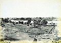 1866年のアフマダーバード古写真。城壁が見える。


気候
[編集]| アフマダーバードの気候 | |||||||||||||
|---|---|---|---|---|---|---|---|---|---|---|---|---|---|
| 月 | 1月 | 2月 | 3月 | 4月 | 5月 | 6月 | 7月 | 8月 | 9月 | 10月 | 11月 | 12月 | 年 |
| 最高気温記録 °C (°F) | 36.1 (97) |
40.6 (105.1) |
43.9 (111) |
46.2 (115.2) |
47.8 (118) |
47.2 (117) |
42.2 (108) |
40.4 (104.7) |
41.7 (107.1) |
42.8 (109) |
38.9 (102) |
35.6 (96.1) |
47.8 (118) |
| 平均最高気温 °C (°F) | 28.3 (82.9) |
30.4 (86.7) |
35.6 (96.1) |
39.8 (103.6) |
41.5 (106.7) |
38.4 (101.1) |
33.4 (92.1) |
31.8 (89.2) |
34.0 (93.2) |
35.8 (96.4) |
32.8 (91) |
29.3 (84.7) |
34.3 (93.7) |
| 日平均気温 °C (°F) | 20.1 (68.2) |
22.2 (72) |
27.3 (81.1) |
31.7 (89.1) |
33.9 (93) |
32.8 (91) |
29.5 (85.1) |
28.2 (82.8) |
29.1 (84.4) |
28.5 (83.3) |
24.7 (76.5) |
21.3 (70.3) |
27.4 (81.3) |
| 平均最低気温 °C (°F) | 11.8 (53.2) |
13.9 (57) |
18.9 (66) |
23.7 (74.7) |
26.2 (79.2) |
27.2 (81) |
25.6 (78.1) |
24.6 (76.3) |
24.2 (75.6) |
21.1 (70) |
16.6 (61.9) |
13.2 (55.8) |
20.6 (69.1) |
| 最低気温記録 °C (°F) | 3.3 (37.9) |
2.2 (36) |
9.4 (48.9) |
12.8 (55) |
19.1 (66.4) |
19.4 (66.9) |
20.4 (68.7) |
21.2 (70.2) |
17.2 (63) |
12.6 (54.7) |
8.3 (46.9) |
3.6 (38.5) |
2.2 (36) |
| 雨量 mm (inch) | 2.2 (0.087) |
1.2 (0.047) |
1.1 (0.043) |
1.9 (0.075) |
9.1 (0.358) |
97.4 (3.835) |
309.8 (12.197) |
213.8 (8.417) |
126.6 (4.984) |
13.5 (0.531) |
6.1 (0.24) |
1.7 (0.067) |
784.4 (30.882) |
| 平均降雨日数 (≥1.0 mm) | 0.3 | 0.3 | 0.1 | 0.3 | 0.9 | 4.8 | 13.6 | 15.0 | 5.8 | 1.1 | 1.1 | 0.3 | 43.6 |
| % 湿度 | 49 | 43 | 37 | 41 | 47 | 62 | 77 | 81 | 71 | 53 | 48 | 50 | 55 |
| 平均月間日照時間 | 287.3 | 274.3 | 277.5 | 297.2 | 329.6 | 238.3 | 130.1 | 111.4 | 220.6 | 290.7 | 274.1 | 288.6 | 3,019.7 |
| 出典1:NOAA (1971–1990),[4] World Meteorological Organization (precipitation 1901–2000)[5] | |||||||||||||
| 出典2:India Meteorological Department (records)[6] | |||||||||||||
世界遺産
[編集]
| |||
|---|---|---|---|
 ポルと呼ばれる集合住宅地 | |||
| 英名 | Historic City of Ahmadabad | ||
| 仏名 | Ville historique d’Ahmedabad | ||
| 面積 | 535.7 ha (緩衝地域 395 ha) | ||
| 登録区分 | 文化遺産 | ||
| 文化区分 | 建造物群 | ||
| 登録基準 | (2), (5) | ||
| 登録年 | 2017年(第41回世界遺産委員会) | ||
| 公式サイト | 世界遺産センター | ||
| 使用方法・表示 | |||

2017年の第41回世界遺産委員会で登録された。
登録基準
[編集]この世界遺産は世界遺産登録基準のうち、以下の条件を満たし、登録された(以下の基準は世界遺産センター公表の登録基準からの翻訳、引用である)。
- (2) ある期間を通じてまたはある文化圏において、建築、技術、記念碑的芸術、都市計画、景観デザインの発展に関し、人類の価値の重要な交流を示すもの。
- (5) ある文化(または複数の文化)を代表する伝統的集落、あるいは陸上ないし海上利用の際立った例。もしくは特に不可逆的な変化の中で存続が危ぶまれている人と環境の関わりあいの際立った例。
交通
[編集]- アフマダーバード駅
- アフマダーバード地下鉄 - 2019年開通。2路線が運行。
- サルダール・ヴァッラブバーイー・パテール国際空港
-
 アフマダーバード駅
 -
 アフマダーバード空港
 -
 市バス・サービス


スポーツ
[編集]
クリケットが最も人気のあるスポーツとなっている。最も象徴的な現代エンターテイメントとも言われ、ボリウッド映画より人気が高いと評される[7]。2021年にはトゥエンティ20形式のプロリーグであるインディアン・プレミアリーグ(IPL)所属のグジャラート・タイタンズが創設された。タイタンズは2022年シーズンで初優勝をしている。ホームスタジアムは収容人数13万2000人のナレンドラ・モディ・スタジアムである[8]。過去には1987年、1996年、2011年のクリケット・ワールドカップの会場として使用された他、2023年にも決勝などで使用される予定である。このスタジアムは2023年現在、収容人数が世界最多のスタジアムとなっている[9]。第18代インド首相のナレンドラ・モディが2009年から2014年までグジャラート・クリケット協会の代表を務めたことから、彼の名前がスタジアム名として名付けられた。2023年には女子プロクリケットリーグの女子プレミアリーグ(WPL)が開幕し、アフマダーバードを本拠地とするクジャラート・ジャイアンツが所属している。
画像
[編集]
-
 ティン・ダルワージャ(3連の門)バドラ城
 -
 デリー・ダルワージャバドラ城
 -
 アダーラジの階段井戸
 -
 アダーラジの階段井戸
 -
 ジャーマー・マスジッド(金曜モスク)
 -
 、シディ・バシール・モスク
 -
 ダーダーハリーのモスクと墓標
 -
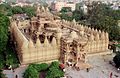
 砂岩の塔ハティーシン·ジャイナ教寺院
 -
 ハティーシン·ジャイナ教寺院
 -
 同寺院の司祭
 -

-
 サーバルマティー・アーシュラム(マハトマ・ガンジーが活動拠点)
 -
 繊維業会館
繊維業会館 -
 サンスカル・ケンドラ美術館
 -
 インド経営大学(IIMA)

.jpg)


_(2792133135).jpg)


脚注
[編集]- ^ “Demographia World Urban Areas - 9th Annual Edition” (PDF) (英語). Demographia (March 2013). 2013年8月2日閲覧。
- ^ “Provisional Population Totals, Census of India 2011 - Urban Agglomerations/Cities having population 1 lakh and above” (PDF) (英語). インド内務省. 2013年8月12日閲覧。
- ^ Sites in Cambodia, China and India added to UNESCO’s World Heritage List (Saturday, 8 July 2017 at 19:00)(世界遺産センター、2017年7月9日)
- ^ “Ahmedabad Climate Normals 1971-1990”. National Oceanic and Atmospheric Administration. January 18, 2014閲覧。
- ^ “World Weather Information Service–Ahmedabad”. World Meteorological Organization. January 18, 2014閲覧。
- ^ “Ever recorded Maximum and minimum temperatures upto 2010” (PDF). India Meteorological Department. January 18, 2014閲覧。
- ^ What India needs is more cricket and less Bollywood Financial Times 2023年9月16日閲覧。
- ^ Narendra Modi Stadium ESPN cricinfo 2023年9月20日閲覧。
- ^ The Biggest Stadiums In The World World Atlas 2023年9月20日閲覧。
関連項目
[編集]- ガンディーナガル - 州都
外部リンク
[編集]- Ahmedabad Urban Development Authority
- Nalsarovar | Ramsar Sites Information Service
 ウィキボヤージュには、アフマダーバードに関する旅行情報があります。
| 2000万以上 | |
|---|---|
| 1000万以上 | |
| 500万以上 | |
| 200万以上 | |
| 100万以上 | |
| 太字は州都または連邦直轄領。人口は都市的地域を含む。 | |
| 全般 | |
|---|---|
| 国立図書館 | |
| 地理 | |
| その他 | |
Text is available under the CC BY-SA 4.0 license; additional terms may apply.
Images, videos and audio are available under their respective licenses.
