アビジャン
| アビジャン自治区 District autonome d'Abidjan | |||||
|---|---|---|---|---|---|
 アビジャン | |||||
| |||||
| 位置 | |||||

| |||||
| 座標 : 北緯5度20分20秒 西経4度1分48秒 / 北緯5.33889度 西経4.03000度 | |||||
| 歴史 | |||||
| 建設 | 1904年 | ||||
| 行政 | |||||
| 国 | |||||
| 自治区 | アビジャン自治区 | ||||
| 市長 | Robert Beugré Mambé | ||||
| 地理 | |||||
| 面積 | |||||
| 自治区域 | 2,140[1] km2 | ||||
| 市街地 | 554 km2 | ||||
| 標高 | 25 m | ||||
| 人口 | |||||
| 人口 | (2014年現在) | ||||
| 自治区域 | 4,707,404人 | ||||
| 人口密度 | 2,200人/km2 | ||||
| 市街地 | 4,395,243人 | ||||
| 市街地人口密度 | 7,944人/km2 | ||||
| その他 | |||||
| 等時帯 | グリニッジ標準時 (UTC+0) | ||||
| ISO 3166-2 | CI-AB | ||||
| 公式ウェブサイト : www.abidjan.district.ci | |||||
アビジャン自治区(アビジャンじちく、仏: District autonome d'Abidjan)、通称アビジャン(Abidjan)は、コートジボワールの最大都市であり、経済や文化の面で西アフリカ全体に影響力を持つ。同国南部に位置する旧首都。アフリカ有数の世界都市であり、2019年のグローバル都市指標によれば世界第92位と評される。
1983年に首都が240km北のヤムスクロに移転されたが、現在も下院の国民議会と最高裁判所が所在し、また国が定めた経済の首都として事実上の首都機能を果たしている[2]。自治区の人口は約470.7万人、市域の人口は約439.5万人(2014年[3])。
歴史
[編集]元々この地はエブリエ族のビジャン部の村があるに過ぎなかったが、1893年にフランス領コートジボワールが成立した後、グラン・バッサムから植民地の首都を遷都する際に、西に40km程行ったこの地にフランス人は目をつけ、先住民を追放した後にビジャンの土地を意味するアビジャン市が建設された。
1904年にアビジャンからニジェールのニアメまでを繋ぐための鉄道の建設が着工された。
1934年7月1日に首都がバンジェルヴィルから遷都され、アビジャンが首都になった。1936年に建設が始まった運河は1950年7月に完成し、運河の完成を以て1951年1月1日にアビジャン港が開港した。鉄道建設は、1954年にオートボルタ(現ブルキナファソ)の首都ワガドゥグーまで延びたところで終了した。
1960年にコートジボワールが独立すると、開放政策によりアビジャンはさらに開発が進み、西アフリカ諸国から多くの移民を受け入れた。1983年3月に同国の首都は内陸部のヤムスクロに遷都したが、現在もアビジャンは同国の政治、経済の中心となっている。
市内の地理
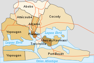
[編集]エブリエ潟を取りかこむように、プラトー、トレッシビル、アジャメ、ココディ、アボボ、ポール・ブエ、ヨープーゴン、マルコリー、アッテクベ、クマシの10の区が広がっている。市の中心街はプラトー地区で、ここに政府官庁や企業が多く立地し、高層ビルが立ち並んでいる。東のココディ地区は高級住宅街で、大使館や豪邸が立ち並ぶ。南のトレッシビルは下町であり、アビジャン・ニジェール鉄道の駅がある。北のアジャメも下町であり、アビジャン最大の市場や長距離バスターミナルがあり、多くの人でにぎわっている。

気候
[編集]| アビジャンの気候 | |||||||||||||
|---|---|---|---|---|---|---|---|---|---|---|---|---|---|
| 月 | 1月 | 2月 | 3月 | 4月 | 5月 | 6月 | 7月 | 8月 | 9月 | 10月 | 11月 | 12月 | 年 |
| 最高気温記録 °C (°F) | 40 (104) |
43 (109) |
41 (106) |
38 (100) |
39 (102) |
39 (102) |
34 (93) |
32 (90) |
35 (95) |
42 (108) |
39 (102) |
39 (102) |
43 (109) |
| 平均最高気温 °C (°F) | 31.1 (88) |
31.7 (89.1) |
31.8 (89.2) |
31.7 (89.1) |
31.0 (87.8) |
29.2 (84.6) |
28.0 (82.4) |
27.5 (81.5) |
28.1 (82.6) |
29.7 (85.5) |
31.1 (88) |
31.0 (87.8) |
30.16 (86.3) |
| 日平均気温 °C (°F) | 26.9 (80.4) |
27.9 (82.2) |
28.1 (82.6) |
28.2 (82.8) |
27.7 (81.9) |
26.5 (79.7) |
25.1 (77.2) |
24.5 (76.1) |
25.6 (78.1) |
26.5 (79.7) |
27.5 (81.5) |
27.4 (81.3) |
26.83 (80.29) |
| 平均最低気温 °C (°F) | 23.9 (75) |
25.0 (77) |
25.2 (77.4) |
25.1 (77.2) |
24.8 (76.6) |
24.1 (75.4) |
23.2 (73.8) |
22.5 (72.5) |
22.8 (73) |
24.0 (75.2) |
24.7 (76.5) |
24.3 (75.7) |
24.13 (75.44) |
| 最低気温記録 °C (°F) | 18 (64) |
19 (66) |
18 (64) |
18 (64) |
18 (64) |
17 (63) |
18 (64) |
17 (63) |
15 (59) |
18 (64) |
19 (66) |
19 (66) |
15 (59) |
| 降水量 mm (inch) | 16.3 (0.642) |
48.9 (1.925) |
106.7 (4.201) |
141.3 (5.563) |
293.5 (11.555) |
651.8 (25.661) |
205.7 (8.098) |
36.8 (1.449) |
80.5 (3.169) |
137.7 (5.421) |
143.3 (5.642) |
75.1 (2.957) |
1,937.6 (76.283) |
| 平均降雨日数 (≥0.1 mm) | 3 | 5 | 9 | 11 | 17 | 21 | 13 | 12 | 12 | 14 | 13 | 7 | 137 |
| % 湿度 | 73 | 71 | 70 | 71 | 75 | 82 | 79 | 79 | 80 | 78 | 73 | 73 | 75.3 |
| 平均月間日照時間 | 210.8 | 209.05 | 220.1 | 216 | 201.5 | 129 | 130.2 | 114.7 | 138 | 204.6 | 225 | 207.7 | 2,206.65 |
| 出典1:Climate Charts (altitude: 8m)[4] Voodoo Skies for record temperatures,[5] World Climate Guide for rainy days[6] | |||||||||||||
| 出典2:Hong Kong Observatory for sunshine,[7] Climatemps.com for humidity[8] | |||||||||||||
経済
[編集]港湾都市であり、コートジボワールの生産物の数々が盛んに輸出されている。主要産業は食品加工、製材、自動車生産、織物工業、化学産業など多数があり、「西アフリカの優等生」と呼ばれる同国の経済活動を物語っている。また、同国最大の石油精製施設もある。また、コートジボワールを代表する空港であるフェリックス・ウフェ=ボワニ国際空港があり、ヨーロッパ・中東・アフリカに翼を伸ばしている。

交通
[編集]空港
[編集]コートジボワールの玄関口としてフェリックス・ウフェ=ボワニ国際空港が所在している。
鉄道
[編集]道路
[編集]アフリカでは珍しく都市高速道路がある。
港湾
[編集]- アビジャン自治港(アビジャン港)
教育
[編集]- アビジャン大学
- Université Félix Houphouët-Boigny
- Higher Institute of Technology of Ivory Coast
- Université Catholique de l'Afrique de l'Ouest
- CIFAD
- Université d'Abobo-Adjamé
- University of Science and Technology of Ivory Coast
スポーツ
[編集]市内施設
[編集]ほとんどの行政官庁や各国大使館が、首都移転後もアビジャンに留まっている。市内には国立図書館や国立美術館などの教育・文化施設もある。
2019年12月16日、市内に日本の資金協力による自動車用高架橋が完成。アラサン・ワタラ大統領やアマドゥ・ゴンクリバリ首相が出席する完成式典が行われた[9]。
対外関係
[編集]姉妹都市・提携都市
[編集] マルセイユ(フランス共和国 プロヴァンス・アルプ・コートダジュール地方 ブーシュ・デュ・ローヌ県)
 ブローニュ・ビヤンクール(フランス共和国 イル・ド・フランス地方 オー・ド・セーヌ県)
 ヴィゼウ(ポルトガル共和国 セントロ地方 ヴィゼウ県)
 横浜市(日本国 関東地方 神奈川県)
 天津市(中華人民共和国 直轄市)
 サンフランシスコ(アメリカ合衆国 カリフォルニア州)
 サンパウロ(ブラジル連邦共和国 サンパウロ州)
 クマシ(ガーナ共和国 アシャンティ州)
 リーブルヴィル(ガボン共和国 エスチュエール州)
 コトヌー(ベナン共和国 リトラル県)
出身者
[編集]脚注
[編集]- ^ “Republic of Côte d'Ivoire”. Citypopulation.de (2019年5月30日). 2021年2月16日閲覧。
- ^ “The World Factbook/Cote d'Ivoire”. 中央情報局 (2021年2月5日). 2021年2月16日閲覧。
- ^ “Abidjan”. Citypopulation.de (2017年7月23日). 2021年2月16日閲覧。
- ^ “Abidjan – Aerodrome, Ivory Coast Climate, Global Warming, and Daylight Charts and Data”. Climate Charts. 2014年1月20日閲覧。
- ^ “Abidjan, Cote d'Ivoire”. Voodoo Skies. 2014年1月20日閲覧。
- ^ “Abidjan Climate Guide, Cote D'Ivoire (Ivory Coast)”. World Climate Guide. 2014年1月20日閲覧。
- ^ “Climatological Normals of Abidjan”. Hong Kong Observatory. 2014年1月20日閲覧。
- ^ “Relative Humidity in Abidjan, Ivory Coast”. Climatemps.com. 2014年1月20日閲覧。
- ^ “日本が資金協力した高架橋が開通 コートジボワール” (2019年12月17日). 2020年2月1日閲覧。
関連項目
[編集]参考文献
[編集]- 鈴木裕之『ストリートの歌 現代アフリカの若者文化』世界思想社、2000年3月。ISBN 4790708071。
外部リンク
[編集] ウィキニュースに関連記事があります。不法投棄で有毒ガス発生、9000人に健康被害―コートジボワール
| 低サッサンドラ地方 | ||
|---|---|---|
| コモエ地方 | ||
| デンゲレ地方 | ||
| ゴー=ジブア地方 | ||
| ラック地方 | ||
| ラギューヌ地方 | ||
| モンターニュ地方 | ||
| サッサンドラ=マラウェ地方 | ||
| サヴァヌ地方 | ||
| バンダマ渓谷地方 | ||
| ウォロバ地方 | ||
| ザンザン地方 | ||
| 自治区 | ||
| 全般 | |
|---|---|
| 国立図書館 | |
| 地理 | |
| その他 | |
Text is available under the CC BY-SA 4.0 license; additional terms may apply.
Images, videos and audio are available under their respective licenses.


