For faster navigation, this Iframe is preloading the Wikiwand page for アバチャ湾.

アバチャ湾

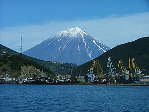
アバチャ湾から見たペトロパブロフスク・カムチャツキーの港とコリャーク(コリャークスキー)火山
地図
アバチャ湾の位置

アバチャ湾ロシア語: Авачинская губа、Avacha Bay)は、カムチャツカ半島の南東岸、半島の先端近くにある。円形に近い形をしており細い水路で太平洋とつながった湾で、湾の大きさは24km、湾口の幅は3km、水深は最大で26m。

アバチャ川が湾内に流れ込んでいる。港湾都市ペトロパブロフスク・カムチャツキーは湾の東側に位置しており、反対側には軍港都市ヴィリュチンスクがある。アバチャ山成層火山、標高2,741m)やコリャーク山成層火山、標高 3,456m)が湾から遠望できる。

関連項目

[編集]
  • ウィキメディア・コモンズには、アバチャ湾に関するカテゴリがあります。


座標: 北緯52度56分0秒 東経158度36分0秒 / 北緯52.93333度 東経158.60000度 / 52.93333; 158.60000

{{bottomLinkPreText}} {{bottomLinkText}}
アバチャ湾
Listen to this article

This browser is not supported by Wikiwand :(
Wikiwand requires a browser with modern capabilities in order to provide you with the best reading experience.
Please download and use one of the following browsers:

This article was just edited, click to reload
This article has been deleted on Wikipedia (Why?)

Back to homepage

Please click Add in the dialog above
Please click Allow in the top-left corner,
then click Install Now in the dialog
Please click Open in the download dialog,
then click Install
Please click the "Downloads" icon in the Safari toolbar, open the first download in the list,
then click Install
{{::$root.activation.text}}

Install Wikiwand

Install on Chrome Install on Firefox
Don't forget to rate us

Tell your friends about Wikiwand!

Gmail Facebook Twitter Link

Enjoying Wikiwand?

Tell your friends and spread the love:
Share on Gmail Share on Facebook Share on Twitter Share on Buffer

Our magic isn't perfect

You can help our automatic cover photo selection by reporting an unsuitable photo.

This photo is visually disturbing This photo is not a good choice

Thank you for helping!


Your input will affect cover photo selection, along with input from other users.

X

Get ready for Wikiwand 2.0 🎉! the new version arrives on September 1st! Don't want to wait?