アジュメール
| アジュメール अजमेर اجمیر Ajmer | |
|---|---|

| |
| 位置 | |

| |
| 座標 : 北緯26度26分28秒 東経74度38分28秒 / 北緯26.44111度 東経74.64111度 | |
| 行政 | |
| 国 | |
| 州 | ラージャスターン州 |
| 県 | アジュメール県 |
| 市 | アジュメール |
| 地理 | |
| 面積 | |
| 市域 | ? km2 |
| 標高 | 486 m |
| 人口 | |
| 人口 | (2001年現在) |
| 市域 | 485,197人 |
| その他 | |
| 等時帯 | インド標準時 (UTC+5:30) |
| 夏時間 | なし |
| Pincode | 305001 |
| 市外局番 | 145 |
| ナンバープレート | RJ01 |
アジュメール(ヒンディー語:अजमेर, ウルドゥー語:اجمیر, 英語:Ajmer)は、インドのラージャスターン州、アジュメール県に属する都市。人口約50万人(2001年)。アジメール、アジミール(Ajmir)とも呼ばれる。
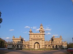
中世のスーフィー聖者フワージャ・ムイーヌッディーン・チシュティーを祀るダルガー(درگاہ:イスラーム聖者廟)の門前町として有名である。参拝客はムスリムに限らず、ヒンドゥーなど多くの人々が聖者の霊験にあずかろうとここに足を運ぶ。また、町にはアクバル大帝の離宮も存在する。
歴史
[編集]
1193年、ゴール朝のムハンマド・ゴーリーに征服される。
1365年、アジュメールはラージプートのメーワール王国領となる。
1509年、メーワール王国とマールワール王国との間でアジュメールをめぐり紛争が発生する。
1553年、スール朝の武将ヘームーが占領し、その死後、1559年にムガル帝国のアクバルが占領。帝国領ラージャスターンの中心地となり、ラージープート諸国支配の中心地となった。また、アクバルはこの地に赴く際、ファテープル・シークリーで聖者サリーム・チシュティーと面会し、男子を授かることを予言されたことは有名である[1]。
18世紀前半、ムガル帝国とラージプートとの間で争奪が繰り返されたのち、マラーター勢力の支配に置かれる。
1818年、アジュメールはシンディア家からイギリスに5万ルピーで売却され、イギリスはここを中心にラージプート諸藩王国を支配した。
地理
[編集]ジャイプルの西、ジョードプルの東に位置する。ニューデリーからムンバイへ続くNH8号線が通っている。
人口
[編集]気候
[編集]| Ajmerの気候 | |||||||||||||
|---|---|---|---|---|---|---|---|---|---|---|---|---|---|
| 月 | 1月 | 2月 | 3月 | 4月 | 5月 | 6月 | 7月 | 8月 | 9月 | 10月 | 11月 | 12月 | 年 |
| 平均最高気温 °C (°F) | 22.9 (73.2) |
25.7 (78.3) |
31.3 (88.3) |
36.5 (97.7) |
39.7 (103.5) |
38.4 (101.1) |
33.6 (92.5) |
31.3 (88.3) |
32.6 (90.7) |
33.5 (92.3) |
29.2 (84.6) |
24.7 (76.5) |
31.62 (88.92) |
| 平均最低気温 °C (°F) | 7.6 (45.7) |
10.5 (50.9) |
16.0 (60.8) |
22.2 (72) |
26.8 (80.2) |
27.5 (81.5) |
25.6 (78.1) |
24.4 (75.9) |
23.7 (74.7) |
18.8 (65.8) |
12.3 (54.1) |
8.4 (47.1) |
18.65 (65.57) |
| 雨量 mm (inch) | 7.3 (0.287) |
6.0 (0.236) |
5.0 (0.197) |
4.0 (0.157) |
15.7 (0.618) |
58.1 (2.287) |
181.5 (7.146) |
157.5 (6.201) |
73.0 (2.874) |
13.1 (0.516) |
4.0 (0.157) |
3.8 (0.15) |
529 (20.826) |
| 出典:IMD[2] | |||||||||||||
交通
[編集]- 鉄道
- アジュメール駅
脚注
[編集]- ^ エスポジト『イスラームの歴史2』、p.190
- ^ “Monthly mean maximum and minimum temperature and total rainfall of important cities (PDF)”. 2015年4月13日時点のオリジナルよりアーカイブ。2013年7月28日閲覧。
参考文献
[編集]- 「アジュメール」『南アジアを知る事典』応地利明、2002年
- 『イスラームの歴史2 拡大する帝国』共同通信社、2005年。
外部リンク
[編集]座標: 北緯26度26分28秒 東経74度38分28秒 / 北緯26.441066度 東経74.641113度
| 全般 | |
|---|---|
| 国立図書館 | |
| その他 | |
Text is available under the CC BY-SA 4.0 license; additional terms may apply.
Images, videos and audio are available under their respective licenses.


