Saint-Désir
Da Wikipedia, l'enciclopedia libera.
| Saint-Désir comune | |
|---|---|
 | |
_(3).jpg) | |
| Localizzazione | |
| Stato | |
| Regione | |
| Dipartimento | |
| Arrondissement | Lisieux |
| Cantone | Mézidon-Canon |
| Territorio | |
| Coordinate | 49°09′N 0°13′E |
| Altitudine | 42 e 172 m s.l.m. |
| Superficie | 19,25 km² |
| Abitanti | 1 775[1] (2009) |
| Densità | 92,21 ab./km² |
| Altre informazioni | |
| Cod. postale | 14100 |
| Fuso orario | UTC+1 |
| Codice INSEE | 14574 |
| Cartografia | |
 Saint-Désir | |
| Sito istituzionale | |
Saint-Désir è un comune francese di 1.775 abitanti situato nel dipartimento del Calvados nella regione della Normandia.
Società
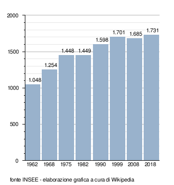
[modifica | modifica wikitesto]Evoluzione demografica
[modifica | modifica wikitesto]Abitanti censiti
Note
[modifica | modifica wikitesto]Altri progetti
[modifica | modifica wikitesto] Wikimedia Commons contiene immagini o altri file su Saint-Désir
Collegamenti esterni
[modifica | modifica wikitesto]- (FR) Sito ufficiale, su saintdesir.fr.
| Controllo di autorità | BNF (FR) cb152479842 (data) |
|---|
Text is available under the CC BY-SA 4.0 license; additional terms may apply.
Images, videos and audio are available under their respective licenses.
Cover photo is available under {{::mainImage.info.license.name || 'Unknown'}} license.
Cover photo is available under {{::mainImage.info.license.name || 'Unknown'}} license.
Credit:
(see original file).
