Le Trait
Da Wikipedia, l'enciclopedia libera.
| Le Trait comune | |
|---|---|
 | |
 | |
| Localizzazione | |
| Stato | |
| Regione | |
| Dipartimento | |
| Arrondissement | Rouen |
| Cantone | Barentin |
| Amministrazione | |
| Sindaco | Patrick Callais dal 2014 |
| Territorio | |
| Coordinate | 49°28′N 0°49′E49°28′N, 0°49′E (Le Trait) |
| Altitudine | 1 - 117 m s.l.m. |
| Superficie | 17,52 km² |
| Abitanti | 5 200[1] (2014) |
| Densità | 296,8 ab./km² |
| Altre informazioni | |
| Cod. postale | 76580 |
| Prefisso | 0235 |
| Fuso orario | UTC+1 |
| Codice INSEE | 76709 |
| Nome abitanti | Traitons |
| Cartografia | |
 Le Trait | |
| Sito istituzionale | |
| Modifica dati su Wikidata · Manuale | |
Le Trait è un comune francese di 5.380 abitanti situato nel dipartimento della Senna Marittima nella regione della Normandia.
Società
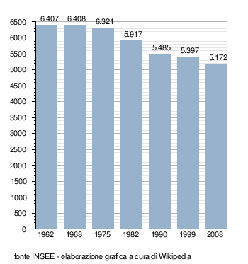
[modifica | modifica wikitesto]Evoluzione demografica
[modifica | modifica wikitesto]Abitanti censiti
Note
[modifica | modifica wikitesto]Altri progetti
[modifica | modifica wikitesto]Altri progetti
 Wikimedia Commons contiene immagini o altri file su Le Trait
Collegamenti esterni
[modifica | modifica wikitesto]- (FR) Sito ufficiale, su letrait.fr.

| Controllo di autorità | VIAF (EN) 148021462 · LCCN (EN) n91070611 · BNF (FR) cb15275292w (data) · J9U (EN, HE) 987007565224105171 |
|---|
Categoria
Text is available under the CC BY-SA 4.0 license; additional terms may apply.
Images, videos and audio are available under their respective licenses.
Cover photo is available under {{::mainImage.info.license.name || 'Unknown'}} license.
Cover photo is available under {{::mainImage.info.license.name || 'Unknown'}} license.
Credit:
(see original file).
