File:Modelare 3D pentru Bazinul Hidrografic al Paraului Latorita.gif
Da Wikipedia, l'enciclopedia libera.
Non sono disponibili versioni a risoluzione più elevata.
Modelare_3D_pentru_Bazinul_Hidrografic_al_Paraului_Latorita.gif (300 × 214 pixel, dimensione del file: 7,21 MB, tipo MIME: image/gif, ciclico, 180 frame, 11 s)
| Questo file e la sua pagina di descrizione (discussione · modifica) si trovano su Wikimedia Commons (?) |
Dettagli
| Descrizione |
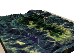
Română: Modelare 3D pentru Bazinul Hidrografic al Râului Latorița. Elevație 130%. Magyar: a Latorca folyó vízgyűjtő területének 3D ábrázolása |
| Data | |
| Fonte | Topographic data SRTM from NASA and World Imagery - NASA World Wind & 3Dem & Inkscape |
| Autore | Asybaris01 |
| Altre versioni |
 |
Clickable map of the (ro:Defileul Oltului)/(en:Defile Olt) drainage basin

Licenza
| This image is in the public domain because it is a screenshot from NASA’s globe software World Wind using a public domain layer, such as Blue Marble, MODIS, Landsat, SRTM, USGS or GLOBE.
|
 |
Cronologia del file
Fare clic su un gruppo data/ora per vedere il file come si presentava nel momento indicato.
| Data/Ora | Miniatura | Dimensioni | Utente | Commento | |
|---|---|---|---|---|---|
| attuale | 09:35, 21 ott 2011 | | 300 × 214 (7,21 MB) | Asybaris01 | ((Information |Description =((ro|1=Modelare 3D pentru Bazinul Hidrografic al Paraului Latorita.gif)) |Source =Topographic data SRTM from NASA and World Imagery - NASA World Wind & 3Dem & Inkscape |Author =Asybaris01 |
Pagine che usano questo file
La seguente pagina usa questo file:
Utilizzo globale del file
Anche i seguenti wiki usano questo file:
- Usato nelle seguenti pagine di af.wikipedia.org:
- Usato nelle seguenti pagine di ar.wikipedia.org:
- Usato nelle seguenti pagine di el.wikipedia.org:
- Usato nelle seguenti pagine di fa.wikipedia.org:
- Usato nelle seguenti pagine di ga.wikipedia.org:
- Usato nelle seguenti pagine di hu.wikipedia.org:
- Usato nelle seguenti pagine di it.wikibooks.org:
- Usato nelle seguenti pagine di ka.wikipedia.org:
- Usato nelle seguenti pagine di ka.wiktionary.org:
- Usato nelle seguenti pagine di kw.wikipedia.org:
- Usato nelle seguenti pagine di lld.wikipedia.org:
- Usato nelle seguenti pagine di ms.wikipedia.org:
- Usato nelle seguenti pagine di my.wikipedia.org:
- Usato nelle seguenti pagine di ro.wikipedia.org:
- Usato nelle seguenti pagine di th.wikipedia.org:
- Usato nelle seguenti pagine di tr.wikipedia.org:
- Usato nelle seguenti pagine di uz.wikipedia.org:
- Usato nelle seguenti pagine di vi.wikipedia.org:
- Usato nelle seguenti pagine di www.wikidata.org:
Text is available under the CC BY-SA 4.0 license; additional terms may apply.
Images, videos and audio are available under their respective licenses.
Cover photo is available under {{::mainImage.info.license.name || 'Unknown'}} license.
Cover photo is available under {{::mainImage.info.license.name || 'Unknown'}} license.
Credit:
(see original file).
