For faster navigation, this Iframe is preloading the Wikiwand page for File:Japanese Empire (orthographic projection).svg.

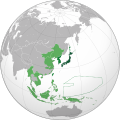
File:Japanese Empire (orthographic projection).svg

Da Wikipedia, l'enciclopedia libera.

File originale(file in formato SVG, dimensioni nominali 600 × 600 pixel, dimensione del file: 665 KB)

Logo di Commons
Logo di Commons
Questo file e la sua pagina di descrizione (discussione · modifica) si trovano su Wikimedia Commons (?)

Dettagli

Descrizione
English: Japanese Empire.
 
Territory (1870–1895).
 
Acquisitions (1895–1930).
 
Acquisitions (1930–1942).
 
South Seas Mandate (1919–1947).
Español: Imperio Japonés.
 
Territorio (1870–1895).
 
Adquisiciones (1895–1930)
 
Adquisiciones (1930–1942).
 
Mandato del Pacífico Sur (1919–1947).
Українська: Японська імперія.
 
Територія (1870–1895).
 
Нові території (1895–1930).
 
Нові території (1930–1942).
 
Південний Тихоокеанський мандат (1919–1947).
日本語:大日本帝国
 
日本 (1870–1895)
 
朝鮮、台湾 (1895–1930)
 
占領地 (1930–1942)
 
委任統治地域南洋群島 (1919–1947)
Data (UTC)
Fonte
Autore Milenioscuro
Altre versioni
This is a Grey & green orthographic projection map.
العربية: الرجاء، قراءة الميثاق.
বাংলা: দয়া করে, রীতিনীতিটি পড়ুন
Deutsch: Bitte lies die Konventionen.
English: Please, read the conventions.
Español: Por favor, lea las convenciones.
Filipino: Paki-basa ang mga kumbensyon.
Français : S'il vous plaît, lisez les conventions.
हिन्दी: कृपया सभागमों को पढ़ लें.
Bahasa Indonesia: Silakan, baca konvensi.
Italiano: Si prega di leggere le convenzioni.
日本語:規約をご確認ください。
ქართული: გთხოვთ, გაეცნოთ კონვენციებს.
Português: Por favor, leia as convenções.
Русский: Пожалуйста, прочитайте соглашения.
Українська: Будь ласка, прочитайте конвенції.
Tiếng Việt: Hãy đọc công văn trước khi đăng.
中文(繁體):請檢視常規
中文(简体):请查看常规
World maps

Africa

हिन्दी: अफ्रीका
ქართული: აფრიკა.

Eastern Africa

Southern Africa

Central Africa

Northern Africa

Western Africa

Americas

ქართული: ამერიკა.
हिन्दी: अमेरिका

North America

Central America

Caribbean

South America

Asia

ქართული: აზია.
Português: Ásia.
Українська: Азія.

East

Português: Ásia Oriental.
Українська: Східна Азія.

Central

हिन्दी: मध्य एशिया
Português: Ásia Central.
Українська: Центральна Азія.

Southeast

Bahasa Indonesia: Asia tenggara
Português: Sudeste Asiático.

South

(भारतीय उपमहाद्वीप)
Português: Sul da Ásia.
Українська: Південна Азія.

Western

Português: Sudoeste da Ásia.
Українська: Передня Азія.

Europe

हिन्दी: यूरोप
ქართული: ევროპა.
Português: Europa.
Română: Europa.
Русский: Европа.
Українська: Європа.

Countries

Oceania

हिन्दी: ओशिआनिया
ქართული: ოკეანეთი.
Português: Oceania.
Українська: Океанія.

Intercontinental

Português: Intercontinental.
Українська: Міжконтинентальні.

Historical

English: Unions, Organizations, Kingdoms, Empires
Español: Uniones, Organizaciones, Reinos, Imperios
Filipino: Mga Unyon, Organisasyon, Kaharian, Imperyo
Français : Unions, Organisations, Royaumes, Empires
हिन्दी: संघ, संगठन, राज्य, साम्राज्य व ऐतिहासिक देश
ქართული: გაერთიანებები, ორგანიზაციები, სამეფოები, იმპერიები
Português: Estados extintos.
Tagalog: Mga Unyon, Organisasyon, Kaharian, Imperyo
Українська: Союзи, Організації, Королівства, Імперії
中文(繁體):聯盟、組織、王國和帝國
中文(简体):联盟、组织、王国和帝国

Subnationals

हिन्दी: उपराष्ट्रीय इकाईयाँ
SVG sviluppo
InfoField
 
Il codice sorgente di questo file SVG è valido.
 
Questa mappa in grafica vettoriale è stata creata con Inkscape.

Licenza

Io, detentore del copyright su quest'opera, dichiaro di pubblicarla con le seguenti licenze:
GNU head È permesso copiare, distribuire e/o modificare questo documento in base ai termini della GNU Free Documentation License, Versione 1.2 o successive pubblicata dalla Free Software Foundation; senza alcuna sezione non modificabile, senza testo di copertina e senza testo di quarta di copertina. Una copia della licenza è inclusa nella sezione intitolata Testo della GNU Free Documentation License.
w:it:Creative Commons
attribuzione condividi allo stesso modo
Questo file è disponibile in base alla licenza Creative Commons Attribuzione-Condividi allo stesso modo 3.0 Unported
Tu sei libero:
  • di condividere – di copiare, distribuire e trasmettere quest'opera
  • di modificare – di adattare l'opera
Alle seguenti condizioni:
  • attribuzione – Devi fornire i crediti appropriati, un collegamento alla licenza e indicare se sono state apportate modifiche. Puoi farlo in qualsiasi modo ragionevole, ma non in alcun modo che suggerisca che il licenziante approvi te o il tuo uso.
  • condividi allo stesso modo – Se remixi, trasformi o sviluppi il materiale, devi distribuire i tuoi contributi in base alla stessa licenza o compatibile all'originale.
Puoi scegliere la licenza che preferisci.

Registro originale del caricamento

This image is a opera derivata of the following images:

Uploaded with derivativeFX

Didascalie

Aggiungi una brevissima spiegazione di ciò che questo file rappresenta
This map represents the Japanese empire. It contains a mistake: new Caledonia was never conquered by Japan.

Elementi ritratti in questo file

raffigura

image/svg+xml

Cronologia del file

Fare clic su un gruppo data/ora per vedere il file come si presentava nel momento indicato.

(ultima | prima) Vedi (10 più recenti | ) (10 | 20 | 50 | 100 | 250 | 500).
Data/OraMiniaturaDimensioniUtenteCommento
attuale05:45, 14 giu 2023Miniatura della versione delle 05:45, 14 giu 2023600 × 600 (665 KB)BankliveReverted to version as of 04:21, 2 May 2022 (UTC) treaty between thailand and japan 1940. The treaty should be used as a reference. The same standard as Switzerland in Europe.
16:54, 21 apr 2023Miniatura della versione delle 16:54, 21 apr 2023600 × 600 (797 KB)LCJapan2034Reverted to version as of 19:32, 15 June 2021 (UTC)
06:21, 2 mag 2022Miniatura della versione delle 06:21, 2 mag 2022600 × 600 (665 KB)TheMysteriousStarReverted to version as of 12:51, 14 June 2021 (UTC) Japan never controlled Thailand
21:32, 15 giu 2021Miniatura della versione delle 21:32, 15 giu 2021600 × 600 (797 KB)MilenioscuroReverted to version as of 21:19, 16 April 2021 (UTC)
14:51, 14 giu 2021Miniatura della versione delle 14:51, 14 giu 2021600 × 600 (665 KB)CommymonoReverted to version as of 11:13, 23 January 2015 (UTC)
23:19, 16 apr 2021Miniatura della versione delle 23:19, 16 apr 2021600 × 600 (797 KB)Milenioscurocorrected size of Dalian/Port Arthur
23:42, 14 nov 2020Miniatura della versione delle 23:42, 14 nov 2020600 × 600 (847 KB)Milenioscuroresolving some really, really, REALLY bad editions of this guys
18:19, 6 ago 2020Miniatura della versione delle 18:19, 6 ago 2020600 × 600 (1,37 MB)Hell - llliobetter borders, added christimas, spratly and paracel islands.
20:07, 6 lug 2020Miniatura della versione delle 20:07, 6 lug 2020600 × 600 (1,24 MB)Hell - lllioFixed Borders in South Yunnan, added Guam, Bonin Islands, Volcano Islands, Wake Islands, Gilbert Islands, Minami-Tori-shima, Okinotorishima and Pescadores.
22:08, 5 lug 2020Miniatura della versione delle 22:08, 5 lug 2020600 × 600 (1,24 MB)Hell - lllioadded Thailand (Under Massive Japanese Influence), Attu and Kiska (Aleutian Islands Campaign) and Parts on the South of the Yunnan Region.
(ultima | prima) Vedi (10 più recenti | ) (10 | 20 | 50 | 100 | 250 | 500).

Pagine che usano questo file

Utilizzo globale del file

Anche i seguenti wiki usano questo file:

Visualizza l'utilizzo globale di questo file.

Metadati

{{bottomLinkPreText}} {{bottomLinkText}}
File:Japanese Empire (orthographic projection).svg
Listen to this article

This browser is not supported by Wikiwand :(
Wikiwand requires a browser with modern capabilities in order to provide you with the best reading experience.
Please download and use one of the following browsers:

This article was just edited, click to reload
This article has been deleted on Wikipedia (Why?)

Back to homepage

Please click Add in the dialog above
Please click Allow in the top-left corner,
then click Install Now in the dialog
Please click Open in the download dialog,
then click Install
Please click the "Downloads" icon in the Safari toolbar, open the first download in the list,
then click Install
{{::$root.activation.text}}

Install Wikiwand

Install on Chrome Install on Firefox
Don't forget to rate us

Tell your friends about Wikiwand!

Gmail Facebook Twitter Link

Enjoying Wikiwand?

Tell your friends and spread the love:
Share on Gmail Share on Facebook Share on Twitter Share on Buffer

Our magic isn't perfect

You can help our automatic cover photo selection by reporting an unsuitable photo.

This photo is visually disturbing This photo is not a good choice

Thank you for helping!


Your input will affect cover photo selection, along with input from other users.

X

Get ready for Wikiwand 2.0 ๐ŸŽ‰! the new version arrives on September 1st! Don't want to wait?