Mynd:Mackenzierivermap.jpg
Stærð þessarar forskoðunar: 542 × 599 mynddílar Aðrar upplausnir: 217 × 240 mynddílar | 434 × 480 mynddílar | 839 × 928 mynddílar.
Upphafleg skrá (839 × 928 mynddílar, skráarstærð: 412 KB, MIME-gerð: image/jpeg)
Lýsing
| Lýsing |
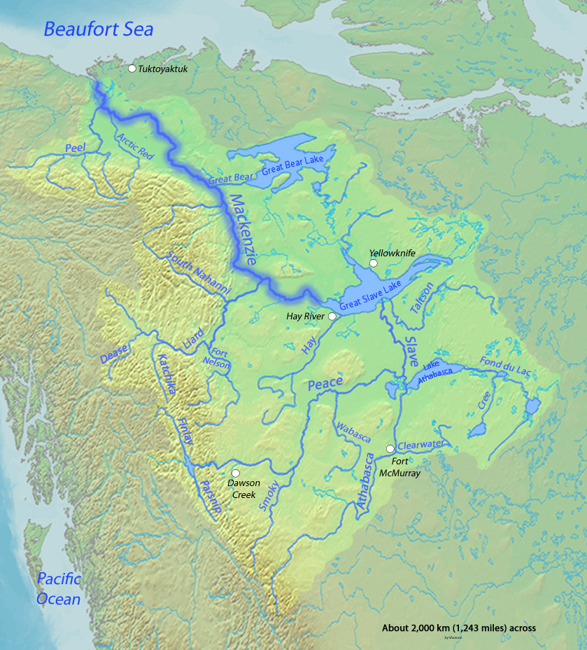
English: Map of the Mackenzie River, second greatest river in North America, that drains to the Arctic Ocean |
| Dagsetning | |
| Uppruni | Background and river course data from http://www2.demis.nl/mapserver/mapper.asp, river names mostly thanks to Image:Major Rivers in West Canada.png |
| Höfundarréttarhafi | Shannon |
Leyfisupplýsingar:
I, the copyright holder of this work, hereby publish it under the following licenses:

|
Gefið er leyfi til að afrita, dreifa og/eða breyta þessu skjali samkvæmt Frjálsa GNU Free Documentation License, útgáfu 1.2 eða nýrri, sem gefið er út af Frjálsu hugbúnaðarstofnuninni með engum breytingum þar á. Afrit af leyfinu er innifalið í kaflanum GNU Free Documentation License. |
This file is licensed under the Creative Commons Attribution-Share Alike 4.0 International, 3.0 Unported, 2.5 Generic, 2.0 Generic and 1.0 Generic license.
- Þér er frjálst:
- að deila – að afrita, deila og yfirfæra verkið
- að blanda – að breyta verkinu
- Undir eftirfarandi skilmálum:
- tilvísun höfundarréttar – Þú verður að tilgreina viðurkenningu á höfundarréttindum, gefa upp tengil á notkunarleyfið og gefa til kynna ef breytingar hafa verið gerðar. Þú getur gert þetta á einhvern ásættanlegan máta, en ekki á nokkurn þann hátt sem bendi til þess að leyfisveitandinn styðji þig eða notkun þína á verkinu.
- Deila eins – Ef þú breytir, yfirfærir eða byggir á þessu efni, þá mátt þú eingöngu dreifa því verki með sama eða svipuðu leyfi og upprunalega verkið er með.
Þú mátt velja notkunarleyfi að eigin vali.
Breytingaskrá skjals
Smelltu á dagsetningu eða tímasetningu til að sjá hvernig hún leit þá út.
| Dagsetning/Tími | Smámynd | Víddir | Notandi | Athugasemd | |
|---|---|---|---|---|---|
| núverandi | 5. mars 2010 kl. 03:56 | | 839 × 928 (412 KB) | Shannon1 | Added scale, etc |
| 5. mars 2010 kl. 03:52 |  | 839 × 928 (408 KB) | Shannon1 | ((Information |Description=((en|1=Map of the Mackenzie River, second greatest river in North America, that drains to the Arctic Ocean)) |Source=Background and river course data from http://www2.demis.nl/mapserver/mapper.asp, river names mostly thanks to [ |
Skráartenglar
Eftirfarandi síða notar þessa skrá:
Altæk notkun skráar
Eftirfarandi wikar nota einnig þessa skrá:
- Notkun á af.wikipedia.org
- Notkun á ar.wikipedia.org
- Notkun á ast.wikipedia.org
- Notkun á ba.wikipedia.org
- Notkun á be-tarask.wikipedia.org
- Notkun á be.wikipedia.org
- Notkun á bg.wikipedia.org
- Notkun á da.wikipedia.org
- Notkun á el.wikipedia.org
- Notkun á en.wikipedia.org
- Notkun á es.wikipedia.org
- Gran Lago del Esclavo
- Gran Lago del Oso
- Alexander MacKenzie
- Río Athabasca
- Lago Athabasca
- Río de la Paz (Canadá)
- Río de los Esclavos
- Río Finlay
- Río Liard
- Río South Nahanni
- Primeras rutas canadienses en canoa
- Río Peel (Canadá)
- Lago Claire
- Pequeño Lago de los Esclavos
- Lago Hottah
- Río Coal
- Río Omineca
- Portaje Methye
- Río Clearwater (Saskatchewan)
- Río Hay
- Río Arctic Red
- Río Pembina
- Río Dease
- Notkun á fa.wikipedia.org
- Notkun á he.wikipedia.org
- Notkun á hr.wikipedia.org
- Notkun á hu.wikipedia.org
- Notkun á io.wikipedia.org
- Notkun á it.wikipedia.org
Skoða frekari altæka notkun þessarar skráar.
Lýsigögn
Text is available under the CC BY-SA 4.0 license; additional terms may apply.
Images, videos and audio are available under their respective licenses.
Cover photo is available under {{::mainImage.info.license.name || 'Unknown'}} license.
Cover photo is available under {{::mainImage.info.license.name || 'Unknown'}} license.
Credit:
(see original file).
