Arkivo:Georgia high detail map.png
Arkivo originala (2 529 × 1 872 pixel-i, grandeso dil arkivo: 340 KB, MIME type: image/png)

|
Tiu ĉi bildo map respektive ĉiuj bildoj en tiu ĉi artikolo aŭ kategorio prefere estu rekreata(j) kiel vektora grafikaĵo en la formato SVG. Vektoraj formatoj por grafikaĵoj havas multajn avantaĝojn, detaloj troveblas anglalingve en la komuneja artikolo Commons:Media for cleanup. Se vi havas aŭ kreas SVG-version de tiu ĉi bildo, bonvolu alŝuti ĝin al la vikipedia komunejo. Post tiu ago, ĉi tiu ŝablono en la bildpaĝo estas anstataŭigenda per la ŝablono ((vector version available|nova dosiera nomo.svg)).
|
Titulo
| Deskripto |
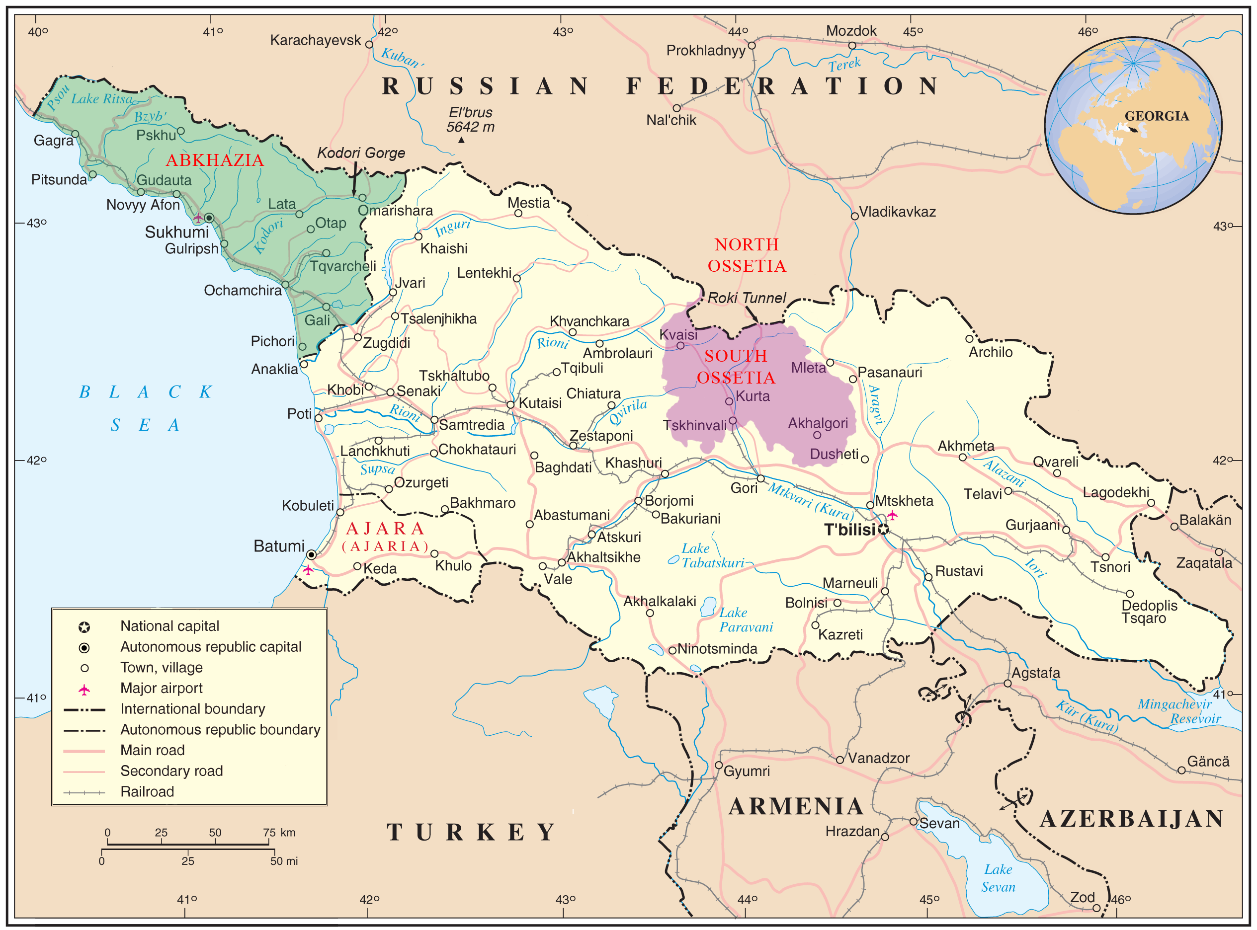
English: Map of Georgia showing the autonomous republics of Abkhazia (de facto independent) and Adjaria, and the de facto independent region of South Ossetia. |
|||
| Dato | ||||
| Fonto | United Nations Cartographic Section, Original unmodified map is at http://www.un.org/Depts/Cartographic/map/profile/georgia.pdf. | |||
| Autoro | United Nations Cartographic Section, with amendments by User:ChrisO | |||
| Yurizo (Riuzo di ica arkivo) |
Public domain | |||
| Altra versioni |
|


| This image is a map derived from a United Nations map.
Unless stated otherwise, UN maps are to be considered in the public domain. This applies worldwide. UN maps are, in principle, open source material and you can use them in your work or for making your own map. UN requests however that you delete the UN name, logo and reference number upon any modification to the map. Content of your map will be your responsibility. You can state in your publication, if you wish, something like: based on UN map … (map name, map number, revision number and date). See: Geospatial Information Section. And: Geospatial, location data for a better world. |
 |
Licencizo
| Io, titolare dei diritti (copyright) su quest'opera, rilascio quest'opera nel pubblico dominio. Questo con effetto in tutto il Mondo. In alcuni paesi questo atto potrebbe non essere riconosciuto valido dalla locale normativa; in tal caso: Riconosco a chiunque e ciascuno il diritto di usare quest'opera per qualsiasi scopo, senza alcuna condizione, a meno che simili condizioni non siano validamente richieste dalla legge. |
Historio dil arkivo
Kliktez sur la dato/horo por vidar arkivo quale ol aparis ye ta tempo.
| Dato/Horo | Miniaturo | Dimensioni | Uzero | Komento | |
|---|---|---|---|---|---|
| aktuala | 11:35, 11 jan. 2009 | | 2 529 × 1 872 (340 KB) | Bestalex | ((Information |Description= |Source= |Date= |Author= |Permission= |other_versions= )) |
| 20:51, 12 di agosto. 2008 |  | 2 529 × 1 872 (330 KB) | ChrisO | ||
| 19:12, 12 di agosto. 2008 |  | 2 529 × 1 872 (331 KB) | ChrisO | ((Information |Description=((en|1=Map of Georgia showing the autonomous republics of Abkhazia and Adjaria, and the breakaway region of South Ossetia. Original unmodified map is at http://www.un.org/Depts/Cartographic/map/profile/georgia.pdf . )) |Source=U |
Ligilo al imajo
Ca pagini ligas al imajo:
Uzado en altra Wiki
La sequanta Wiki anke uzas ica arkivo:
- Uzado en af.wikipedia.org
- Uzado en ar.wikipedia.org
- Uzado en azb.wikipedia.org
- Uzado en az.wikipedia.org
- Uzado en az.wiktionary.org
- Uzado en bn.wikipedia.org
- Uzado en bxr.wikipedia.org
- Uzado en ca.wikipedia.org
- Uzado en cs.wikipedia.org
- Uzado en cy.wikipedia.org
- Uzado en el.wikipedia.org
- Uzado en en.wikipedia.org
- Georgia (country)
- South Ossetia
- Georgian–Ossetian conflict
- Roki Tunnel
- Kosovo independence precedent
- Outline of Abkhazia
- Abkhazia
- Talk:Georgia (country)/Archive 5
- User:Kazkaskazkasako/Books/History
- Georgia–Russia border
- Wikipedia:Graphics Lab/Map workshop/Archive/Jul 2014
- User:Mschiffler/sandbox1
- Water supply and sanitation in Georgia
- Proposed Russian annexation of South Ossetia
- User:Royal Georgian/sandbox
- Uzado en eo.wikipedia.org
- Uzado en es.wikipedia.org
- Uzado en et.wikipedia.org
- Uzado en fa.wikipedia.org
- Uzado en fi.wikipedia.org
- Uzado en fi.wikivoyage.org
Videz altra uzadi por ica artiklo.
Text is available under the CC BY-SA 4.0 license; additional terms may apply.
Images, videos and audio are available under their respective licenses.
