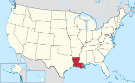
Louisiana
| Estado iti Louisiana | |
|---|---|
| Birngas: Bayou State Child of the Mississippi Creole State Pelican State (opisial) Sportsman's Paradise Sugar State | |
| Pasasao: Union, Justice and Confidence Union, justice, et confiance (Frances) Lunyon, Jistis, é Konfyans (Louisiana Creole) | |
 | |
| Opisial a pagsasao | None (Ingles ken Francia de facto) |
| Nagan dagiti umili | Louisianian, Louisianais (Frances) Lwizyané(èz) (Creole) |
| Kapitolio | Baton Rouge |
| Kadakkelan a siudad | New Orleans[1][2][3] |
| Kadakkelan a metro | New Orleans metropolitan a lugar |
| Kalawa | Maika-31 |
| - Dagup | 51,843 sq mi (135,382 km2) |
| - Kaakaba | 130-milia (210 km) |
| - Kaatiddog | 379-milia (610 km) |
| - % ti danum | 15 |
| - Latitud | 28° 56′ N to 33° 01′ N |
| - Longitud | 88° 49′ W to 94° 03′ W |
| Populasion | Maika-25 |
| - Dagup | 4,574,836 (2011 karkulo) |
| - Densidad | 105/sq mi (40.5/km2) Maika-24 |
| Kangato | |
| - Kangatuan a punto | Driskill Mountain[4][5] 535 ft (163 m) |
| - Pagtengngaan | 100 ft (30 m) |
| - Kababaan a punto | New Orleans[4][5] -8 ft (-2.5 m) |
| Sakbay a naestado | Territory of Orleans |
| Pannakaawat iti kappon | Abril 30, 1812 (Maika-18) |
| Gobernador | Bobby Jindal (R) |
| Teniente Gobernador | Jay Dardenne (R) |
| Lehislatura | State Legislature |
| - Akinngato a Kamara | State Senado |
| - Akinbaba a Kamara | House of Representatives |
| Dagiti senador | Mary Landrieu (D) David Vitter (R) |
| Dagiti delegado | 6 Republikano, 1 Demokrata (listaan) |
| Sona ti oras | Central: UTC-6/-5 |
| ISO 3166 | US-LA |
| Pangyababaan | LA, |
| Website | louisiana |
Nagsasabtan: 31°N 92°W / 31°N 92°W
Ti Estado iti Louisiana (English): State of Louisiana) ket maysa nga estado a mabirukan idiay abagatan a rehion iti Estados Unidos.
Dagiti nagibasaran
[urnosen | urnosen ti taudan]- ^ New Orleans a 'ghost town' after thousands flee Gustav: mayor Agosto 31, 2008.
- ^ "Expert: N.O. population at 273,000". WWL-TV. Agosto 7, 2007. Naiyarkibo manipud iti kasisigud idi 2007-09-26. Naala idi 2007-08-14.
- ^ "Relocation". Connecting U.S. Cities. Mayo 3, 2007. Naiyarkibo manipud iti kasisigud idi 2014-02-09. Naala idi 2011-12-27.
- ^ a b "Elevations and Distances in the United States". United States Geological Survey. 2001. Naiyarkibo manipud iti kasisigud idi 2011-10-15. Naala idi Oktubre 21, 2011.
- ^ a b Elevation adjusted to North American Vertical Datum of 1988.
Politikal a panakabingbingay iti Estados Unidos | |
|---|---|
| Dagiti estado |
|
| Pederal a distrito | |
| Insular a luglugar |
|
Text is available under the CC BY-SA 4.0 license; additional terms may apply.
Images, videos and audio are available under their respective licenses.


