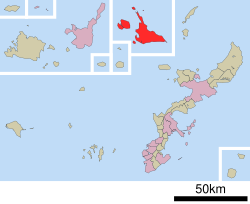
Miyakojima, Okinawa
Kota Miyakojima
宮古島市 Myaaku Naaku | |
|---|---|
Kota | |
 | |
 Lokasi Kota Miyakojima di Okinawa (Miyako) | |
| Negara | Jepang |
| Wilayah | Kyushu (Kepulauan Ryukyu) |
| Prefektur | Okinawa (Miyako) |
| Pemerintahan | |
| • Wali Kota | Toshihiko Shimoji[1] |
| Luas | |
| • Total | 204,54 km2 (7,897 sq mi) |
| Populasi (November 2011) | |
| • Total | 54.888 |
| • Kepadatan | 268/km2 (690/sq mi) |
| Lambang | |
| • Pohon | Banyan |
| • Bunga | kembang kertas dan dadap |
| • Burung | Butastur indicus |
| • Kupu-kupu | Idea leuconoe |
| • Ikan | Pterocaesio digramma |
| • Lainnya | Kerang: Lambis chiragra |
| Zona waktu | UTC+9 (JST) |
| Alamat balai kota | 186 Hirara Nishizato, Miyakojima-shi, Okinawa-ken 906-8501 |
| Situs web | Kota Miyakojima |
Miyakojima (宮古島市, Miyakojima-shi, Miyako: Myaaku, Okinawa: Naaku) adalah sebuah kota di Kepulauan Miyako, Prefektur Okinawa, Jepang. Kota ini dibentuk pada 1 Oktober 2005 sebagai hasil merger Kota Hirara, Kota Madya Gusukube, Irabu dan Shimoji, serta Desa Ueno yang seluruhnya berasal dari Distrik Miyako.
Luas wilayah kota 20.454 kilometer (12.710 mi). Pada bulan November 2011, populasi penduduk 54.888 orang dengan kepadatan penduduk 288 per km². Di kota ini terdapat sejumlah 24.702 rumah tangga.[2]
Pulau-pulau yang termasuk wilayah Kota Miyakojima:
- Miyakojima
- Pulau Ikema
- Pulau Ōgami
- Pulau Kurima
- Pulau Irabu
- Pulau Shimoji
Iklim
[sunting | sunting sumber]Miyakojima beriklim subtropis basah (klasifikasi iklim Köppen Cfa) berbatasan dengan iklim hutan hujan tropis (Köppen Af) dengan musim panas sangat hangat dan suhu sedang pada musim dingin. Presipitasi tinggi sepanjang tahun; Agustus adalah bulan terbasah dan Maret adalah bulan terkering.
| Data iklim Miyakojima | |||||||||||||
|---|---|---|---|---|---|---|---|---|---|---|---|---|---|
| Bulan | Jan | Feb | Mar | Apr | Mei | Jun | Jul | Agt | Sep | Okt | Nov | Des | Tahun |
| Rata-rata tertinggi °C (°F) | 19.8 (67.6) |
20.3 (68.5) |
22.1 (71.8) |
25.1 (77.2) |
27.7 (81.9) |
29.5 (85.1) |
31.3 (88.3) |
30.9 (87.6) |
30.0 (86) |
27.6 (81.7) |
24.6 (76.3) |
21.5 (70.7) |
25.87 (78.56) |
| Rata-rata harian °C (°F) | 17.2 (63) |
17.6 (63.7) |
19.3 (66.7) |
22.1 (71.8) |
24.8 (76.6) |
26.8 (80.2) |
28.3 (82.9) |
28.0 (82.4) |
27.1 (80.8) |
24.9 (76.8) |
22.1 (71.8) |
19.0 (66.2) |
23.1 (73.57) |
| Rata-rata terendah °C (°F) | 15.0 (59) |
15.3 (59.5) |
17.0 (62.6) |
19.7 (67.5) |
22.5 (72.5) |
24.7 (76.5) |
25.9 (78.6) |
25.6 (78.1) |
24.8 (76.6) |
22.9 (73.2) |
20.2 (68.4) |
17.0 (62.6) |
20.88 (69.59) |
| Presipitasi mm (inci) | 141.4 (5.567) |
132.5 (5.217) |
129.5 (5.098) |
172.1 (6.776) |
193.2 (7.606) |
217.0 (8.543) |
162.5 (6.398) |
226.6 (8.921) |
199.1 (7.839) |
161.8 (6.37) |
145.2 (5.717) |
152.3 (5.996) |
2.033,2 (80,048) |
| % kelembapan | 73 | 77 | 79 | 81 | 84 | 86 | 82 | 82 | 81 | 76 | 75 | 73 | 79.1 |
| Rata-rata sinar matahari bulanan | 91.5 | 84.5 | 114.9 | 146.9 | 157.3 | 194.1 | 261.0 | 236.5 | 204.5 | 167.6 | 108.6 | 97.4 | 1.864,8 |
| Sumber: NOAA (1961-1990) [3] | |||||||||||||
Transportasi
[sunting | sunting sumber]Kota Miyakojima dilayani oleh dua bandar udara. Bandar Udara Miyako berada di Pulau Miyako dan Bandar Udara Shimojishima berada di Pulau Shimoji.
Tokoh terkenal
[sunting | sunting sumber]- Hideki Irabu, pemain bisbol
- Katsuyoshi Tomori, pegolf
- Kazumasa Uesato, pemain sepak bola
- Masanobu Kikukawa, seniman bela diri
- Mikio Shimoji, politikus
Ekonomi
[sunting | sunting sumber]Japan Airlines memiliki kantor tiket di Kota Miyakojima, Pulau Miyako.[4]
Referensi
[sunting | sunting sumber]- ^ "市長プロフィール" (dalam bahasa Jepang). Miyakojima City, Okinawa Prefecture, Japan: Miyakojima City. 2012. Diakses tanggal Dec. 18, 2012.
- ^ "宮古島市の人口" (dalam bahasa Jepang). Miyakojima City, Okinawa Prefecture, Japan: Miyakojima City. 2011. Diakses tanggal Dec. 18, 2012.
- ^ "Miyakojima Climate Normals 1961-1990". National Oceanic and Atmospheric Administration. Diakses tanggal January 9, 2013.
- ^ "JAL Group Offices Information." Japan Airlines. Diakses 22 Juli 2011. "MIYAKO Only Domestic Ticketing Available Address 223 Nishizato Hirara Miyako City, 906-0012" Map Diarsipkan 2014-10-26 di Wayback Machine.
Pranala luar
[sunting | sunting sumber]- (Jepang) Kota Miyakojima
- (Jepang) Panduan wisata Miyakojima
| Kota inti | |||||||||||
|---|---|---|---|---|---|---|---|---|---|---|---|
| Kota | |||||||||||
| Kota kecil dan desa |
| ||||||||||
| Umum | |
|---|---|
| Perpustakaan nasional | |
| Lain-lain | |
Text is available under the CC BY-SA 4.0 license; additional terms may apply.
Images, videos and audio are available under their respective licenses.

