Hirono, Fukushima
Hirono
広野町 | |
|---|---|
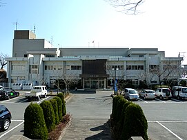
 Balai Kota Hirono | |
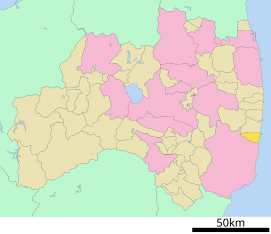
 Lokasi Hirono di Prefektur Fukushima | |
| Koordinat: 37°12′52″N 140°59′40″E / 37.21444°N 140.99444°E | |
| Negara | |
| Wilayah | Tōhoku |
| Prefektur | |
| Distrik | Futaba |
| Pemerintahan | |
| • Walikota | Satoshi Endō |
| Luas | |
| • Total | 58,69 km2 (22,66 sq mi) |
| Populasi (31 Maret 2020) | |
| • Total | 4,755 |
| • Kepadatan | 81,02/km2 (209,8/sq mi) |
| Zona waktu | UTC+09:00 (JST) |
| Nomor telepon | 0240-27-2111 |
| Alamat balai kota | 35 Aza Nawashirogae, Ōaza Shimokitaba, Hirono-machi, Futaba-gun, Fukushima-ken 979-0402 |
| Lambang | |
| • Pohon | Sakura |
| • Bunga | Yamayuri (Lilium auratum) |
| • Burung | Mejiro (Zosterops japonicus) |
| Situs web | www |


Hirono (広野町, Hirono-machi) adalah sebuah kota yang terletak di Prefektur Fukushima, Jepang.
Per 31 Maret 2020, kota ini memiliki estimasi jumlah penduduk sebesar 4.755 jiwa dan kepadatan penduduk sebesar 81,02 orang per km², yang terbagi dalam 2.267 KK.[1] Kota ini memiliki luas wilayah sebesar 58,69 kilometer persegi (22,66 sq mi).[2]
Geografi
[sunting | sunting sumber]Iklim
[sunting | sunting sumber]| Data iklim Hirono (1991−2020 normal, ekstrim 1976−sekarang) | |||||||||||||
|---|---|---|---|---|---|---|---|---|---|---|---|---|---|
| Bulan | Jan | Feb | Mar | Apr | Mei | Jun | Jul | Agt | Sep | Okt | Nov | Des | Tahun |
| Rekor tertinggi °C (°F) | 18.4 (65.1) |
22.8 (73) |
23.9 (75) |
28.2 (82.8) |
31.8 (89.2) |
34.9 (94.8) |
37.3 (99.1) |
37.0 (98.6) |
35.2 (95.4) |
31.6 (88.9) |
25.6 (78.1) |
23.0 (73.4) |
37.3 (99.1) |
| Rata-rata tertinggi °C (°F) | 7.9 (46.2) |
8.2 (46.8) |
11.0 (51.8) |
15.6 (60.1) |
19.6 (67.3) |
22.3 (72.1) |
26.1 (79) |
27.7 (81.9) |
24.9 (76.8) |
20.3 (68.5) |
15.6 (60.1) |
10.7 (51.3) |
17.49 (63.49) |
| Rata-rata harian °C (°F) | 3.3 (37.9) |
3.5 (38.3) |
6.3 (43.3) |
10.9 (51.6) |
15.3 (59.5) |
18.6 (65.5) |
22.4 (72.3) |
24.0 (75.2) |
21.1 (70) |
16.0 (60.8) |
10.8 (51.4) |
5.9 (42.6) |
13.18 (55.7) |
| Rata-rata terendah °C (°F) | −1.3 (29.7) |
−1.2 (29.8) |
1.4 (34.5) |
6.1 (43) |
11.0 (51.8) |
15.3 (59.5) |
19.5 (67.1) |
21.1 (70) |
17.7 (63.9) |
11.9 (53.4) |
6.0 (42.8) |
1.0 (33.8) |
9.04 (48.27) |
| Rekor terendah °C (°F) | −10.5 (13.1) |
−10.2 (13.6) |
−6.9 (19.6) |
−3.8 (25.2) |
0.8 (33.4) |
5.5 (41.9) |
10.4 (50.7) |
10.6 (51.1) |
7.9 (46.2) |
−0.2 (31.6) |
−4.2 (24.4) |
−7.5 (18.5) |
−10.5 (13.1) |
| Presipitasi mm (inci) | 58.3 (2.295) |
51.4 (2.024) |
109.5 (4.311) |
133.8 (5.268) |
151.5 (5.965) |
165.3 (6.508) |
191.3 (7.531) |
143.5 (5.65) |
222.7 (8.768) |
227.1 (8.941) |
85.7 (3.374) |
52.2 (2.055) |
1.600,3 (63,004) |
| Rata-rata hari hujan atau bersalju (≥ 1.0 mm) | 4.8 | 5.1 | 9.0 | 9.7 | 10.5 | 12.1 | 13.0 | 10.6 | 12.5 | 10.6 | 6.8 | 5.2 | 109.9 |
| Rata-rata sinar matahari bulanan | 189.9 | 183.2 | 191.0 | 192.4 | 194.1 | 151.6 | 147.5 | 175.0 | 137.5 | 144.8 | 160.3 | 174.7 | 2.041,7 |
| Sumber: Japan Meteorological Agency[3][4] | |||||||||||||
Munisipalitas yang berdekatan
[sunting | sunting sumber]Hirono berbatasan dengan dua munisipalitas yang berada di wilayah Prefektur Fukushima, yaitu :
Referensi
[sunting | sunting sumber]- ^ Official statistics from home page (dalam bahasa Jepang)
- ^ "Home Page" (dalam bahasa Jepang). Hirono Town. Diakses tanggal 6 Februari 2015.
- ^ 観測史上1~10位の値(年間を通じての値). JMA. Diakses tanggal 20 Maret 2022.
- ^ 気象庁 / 平年値(年・月ごとの値). JMA. Diakses tanggal 20 Maret 2022.
Pranala luar
[sunting | sunting sumber]- Situs web resmi (dalam bahasa Jepang)
Text is available under the CC BY-SA 4.0 license; additional terms may apply.
Images, videos and audio are available under their respective licenses.


