For faster navigation, this Iframe is preloading the Wikiwand page for Berkas:Somaliland. Anglo-Italian Boundary Commission 1929-1930. Index to Field sheets etc. War Office ledger (WOOS-33-1).jpg.

Berkas:Somaliland. Anglo-Italian Boundary Commission 1929-1930. Index to Field sheets etc. War Office ledger (WOOS-33-1).jpg
Ukuran asli(5.405 × 5.533 piksel, ukuran berkas: 24,95 MB, tipe MIME: image/jpeg)

Berkas ini berasal dari Wikimedia Commons dan mungkin digunakan oleh proyek-proyek lain. Deskripsi dari halaman deskripsinya ditunjukkan di bawah ini.

Ringkasan

; ;
Judul
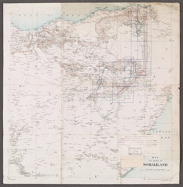
Somaliland. Anglo-Italian Boundary Commission 1929-1930.' 'Index to Field sheets etc.' - War Office ledger (WOOS/33/1)
Deskripsi
Graphic index portraying extent of Boundary Survey (air photos), British field sheets and Italian field sheets, as filed at WOOS/33/2. Information added in manuscript to lithographed base map. Legend affixed to map face.Base map is G.S.G.S. 1781, revised October 1906 as T.S.G.S. 1781, titled 'Map of a portion of Somaliland' and filed at Maps MOD IDWO 1781. Portrays hydrology, relief by form lines and spot heights, roads and tracks, settlements, water sources, international boundaries and place names. Creation start date derived from earliest use of designation 'G.S.G.S.'
British Library Shelfmark
InfoField
WOOS/33/1
Locations Depicted
InfoField
British Somaliland, Africa, 1884-1960 Italian Somaliland, Africa, 1889-1936
Centre Point Coordinates
InfoField
8.0000,47.0000
Tanggal [1909]-1930
Sumber
This file has been provided by the British Library from its digital collections. A full catalogue record for the item shown is available on the British Library website.


This tag does not indicate the copyright status of the attached work. A normal copyright tag is still required. See Commons:Licensing.


বাংলা | Deutsch | English | español | euskara | français | galego | hrvatski | italiano | 日本語 | македонски | polski | русский | українська | 中文 | +/−

Pencipta

Anglo-Italian Somaliland Boundary Commission, 1929-1930, Publisher Phipps, John Faviell, 1894-1964, army officer, Surveyor Stafford, John Howard, fl 1918-1966, army officer, Surveyor

Taylor, Richard Harold Redvers, 1900-1975, army officer and artist, Surveyor
Izin
(Menggunakan kembali berkas ini)
Royal Coat of Arms of the United Kingdom
This file is licensed under the Open Government Licence version 1.0 (OGL v1.0).
You are free to:
  • copy, publish, distribute and transmit the Information;
  • adapt the Information;
  • exploit the Information commercially for example, by combining it with other Information, or by including it in your own product or application.
You must, where you do any of the above:
  • acknowledge the source of the Information by including any attribution statement specified by the Information Provider(s) and, where possible, provide a link to this licence;
  • ensure that you do not use the Information in a way that suggests any official status or that the Information Provider endorses you or your use of the Information;
  • ensure that you do not mislead others or misrepresent the Information or its source;
  • ensure that your use of the Information does not breach the Data Protection Act 1998 or the Privacy and Electronic Communications (EC Directive) Regulations 2003.

See the Open Government Licence page on Meta-Wiki for more information.

 Geotemporal data
Map location Somaliland
Scale Scale 1:1,000,000
Bounding box
11°00′00″N 44°00′00″E / 11.0000°N 44.0000°E / 11.0000; 44.0000 11°00′00″N 50°00′00″E / 11.0000°N 50.0000°E / 11.0000; 50.0000
5°00′00″N 44°00′00″E / 5.0000°N 44.0000°E / 5.0000; 44.0000 5°00′00″N 50°00′00″E / 5.0000°N 50.0000°E / 5.0000; 50.0000
Georeferencing Georeference the map in Wikimaps Warper If inappropriate please set warp_status = skip to hide.
 Archival data
institution QS:P195,Q23308
Ukuran 74 x 73cm
Bahan Printed, with manuscript additions in coloured ink, watercolour and pencil
Catatan For more information please see the British Library’s Collection Guide to the War Office Archive. Archived from the original on 2016-01-11. Retrieved on 2018-03-28.

Captions

Add a one-line explanation of what this file represents

Items portrayed in this file

menggambarkan

Riwayat berkas

Klik pada tanggal/waktu untuk melihat berkas ini pada saat tersebut.

Tanggal/WaktuMiniaturDimensiPenggunaKomentar
terkini28 Maret 2018 12.09Miniatur versi sejak 28 Maret 2018 12.095.405 × 5.533 (24,95 MB)NdalyroseGWToolset: Creating mediafile for Ndalyrose.

Penggunaan berkas

Halaman berikut menggunakan berkas ini:

Penggunaan berkas global

Metadata

{{bottomLinkPreText}} {{bottomLinkText}}
Berkas:Somaliland. Anglo-Italian Boundary Commission 1929-1930. Index to Field sheets etc. War Office ledger (WOOS-33-1).jpg
Listen to this article

This browser is not supported by Wikiwand :(
Wikiwand requires a browser with modern capabilities in order to provide you with the best reading experience.
Please download and use one of the following browsers:

This article was just edited, click to reload
This article has been deleted on Wikipedia (Why?)

Back to homepage

Please click Add in the dialog above
Please click Allow in the top-left corner,
then click Install Now in the dialog
Please click Open in the download dialog,
then click Install
Please click the "Downloads" icon in the Safari toolbar, open the first download in the list,
then click Install
{{::$root.activation.text}}

Install Wikiwand

Install on Chrome Install on Firefox
Don't forget to rate us

Tell your friends about Wikiwand!

Gmail Facebook Twitter Link

Enjoying Wikiwand?

Tell your friends and spread the love:
Share on Gmail Share on Facebook Share on Twitter Share on Buffer

Our magic isn't perfect

You can help our automatic cover photo selection by reporting an unsuitable photo.

This photo is visually disturbing This photo is not a good choice

Thank you for helping!


Your input will affect cover photo selection, along with input from other users.

X

Get ready for Wikiwand 2.0 🎉! the new version arrives on September 1st! Don't want to wait?