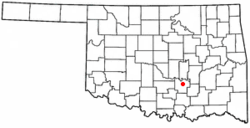
Ada, Oklahoma
Ada, Oklahoma | |
|---|---|
 Balai Kota Ada | |
 Letak di Negara Bagian Oklahoma | |
| Koordinat: 34°45′49″N 96°40′6″W / 34.76361°N 96.66833°W | |
| Negara | |
| Negara bagian | |
| Wilayah | Pontotoc |
| Kantor pos | 1891 |
| Pemerintahan | |
| • Jenis | Dewan kota |
| • Wali kota | Tre Landrum |
| Luas | |
| • Total | 40,8 km2 (15,8 sq mi) |
| • Luas daratan | 40,7 km2 (15,7 sq mi) |
| • Luas perairan | ,2 km2 (,1 sq mi) 0% |
| Ketinggian | 308 m (1.010 ft) |
| Populasi (2010) | |
| • Total | 17.140 |
| • Kepadatan | 417,1/km2 (1.077,2/sq mi) |
| • Demonim | Adan |
| Zona waktu | UTC-6 (CST) |
| • Musim panas (DST) | UTC-5 (CDT) |
| Kode ZIP | 74820-74821 |
| Kode area telepon | 580 |
| Kode FIPS | 40-00200[1] |
| ID fitur GNIS | 1089523[2] |
| Situs web | adaok.com |
Ada adalah sebuah kota di dan ibu kota wilayah of Wilayah Pontotoc, Oklahoma, Amerika Serikat.[3]Penduduknya mencapai 16.810 jiwa menurut sensus 2010, pertumbuhan sebesar 7,1 persen dari hanya 15.691 jiwa pada sensus 2000.[4] Kota ini dinamai dari Ada Reed, anak perempuan dari salah satu pemukim awal di kota in. Kota ini tergabung pada 1901.[5] Ada adalah tempat Universitas East Central dan kantor pusat Chikasaw Nation.
Ada adalah Kota Jalan Utama Oklahoma, Kota Tersertifikasi Oklahoma, dan anggota Tree City USA.
Tempat bersejarah yang terdaftar secara nasional
[sunting | sunting sumber]Ada memiliki beberapa tempat bersejarah yang terdaftar secara nasional. Tempat-tempat tersebut antara lain Perpustakaan Umum Ada, Rumah Bundar Lapangan Bebee, Sekolah Normal Negeri East Central, Distrik Industri Mijo Camp, Gedung Pengadilan Wilayah Pontotoc, Klinik Sugg, dan Distrik Bersejarah Taman Winttersmith.
Rujukan
[sunting | sunting sumber]- ^ "American FactFinder". United States Census Bureau. Diarsipkan dari versi asli tanggal 2013-09-11. Diakses tanggal 2008-01-31.
- ^ "US Board on Geographic Names". United States Geological Survey. 2007-10-25. Diakses tanggal 2008-01-31.
- ^ "Find a County". National Association of Counties. Diarsipkan dari versi asli tanggal 2011-05-31. Diakses tanggal 2011-06-07.
- ^ "Ada, OK Population - Census 2010 and 2000 Interactive Map, Demographics, Statistics, Quick Facts - CensusViewer". censusviewer.com. Diarsipkan dari versi asli tanggal 2013-06-15. Diakses tanggal 19 October 2018.
- ^ "About Ada". 2007-08-12. Diarsipkan dari versi asli tanggal 2007-08-12. Diakses tanggal 2018-09-12.
Pranala luar
[sunting | sunting sumber]- City website
- Community website Diarsipkan 2016-07-22 di Wayback Machine.
- Ada photos on Flickr (unofficial)
- Oklahoma Main Street Community program
- http://www.adachamber.com/ Diarsipkan 2010-12-11 di Wayback Machine.
- Encyclopedia of Oklahoma History and Culture - Ada Diarsipkan 2016-05-05 di Wayback Machine.
Text is available under the CC BY-SA 4.0 license; additional terms may apply.
Images, videos and audio are available under their respective licenses.
