Talin
Ez a szócikk nem tünteti fel a független forrásokat, amelyeket felhasználtak a készítése során. Emiatt nem tudjuk közvetlenül ellenőrizni, hogy a szócikkben szereplő állítások helytállóak-e. Segíts megbízható forrásokat találni az állításokhoz! Lásd még: A Wikipédia nem az első közlés helye.
Nem tévesztendő össze a következővel: Tallinn.
| Talin (Թալին) | |||
 | |||
| Talin környéke | |||
| |||
| Közigazgatás | |||
| Ország | |||
| Tartomány | Aragacotn | ||
| Alapítás éve | 2. század | ||
| Polgármester | Mnacakan Mnacakanjan | ||
| Irányítószám | 0501 | ||
| Testvérvárosok | Lista | ||
| Népesség | |||
| Teljes népesség | 4981 fő (2001) | ||
| Földrajzi adatok | |||
| Tszf. magasság | 1585 m | ||
| Terület | 7,0 km² | ||
| Időzóna | UTC+04:00 | ||
| Elhelyezkedése | |||
 | |||
| Talin weboldala | |||
A Wikimédia Commons tartalmaz Talin témájú médiaállományokat. | |||
| Sablon • Wikidata • Segítség | |||


Talin (örményül: Թալին) város Örményországban Aragacotn tartomány nyugati részén. A városban található a 7. századi Talini Székesegyház. Lakosainak száma 5371.
Galéria
[szerkesztés]-
 A székesegyház
 -
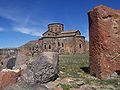 Talin székesegyháza
 -
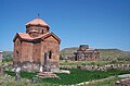 Történelmi kápolna


Text is available under the CC BY-SA 4.0 license; additional terms may apply.
Images, videos and audio are available under their respective licenses.
Cover photo is available under {{::mainImage.info.license.name || 'Unknown'}} license.
Cover photo is available under {{::mainImage.info.license.name || 'Unknown'}} license.
Credit:
(see original file).
