Fájl:BARANYA.png
Az előnézet mérete: 556 × 600 képpont További felbontások: 222 × 240 képpont | 445 × 480 képpont | 777 × 838 képpont.
Eredeti fájl (777 × 838 képpont, fájlméret: 37 KB, MIME-típus: image/png)
Összefoglaló
| Leírás |
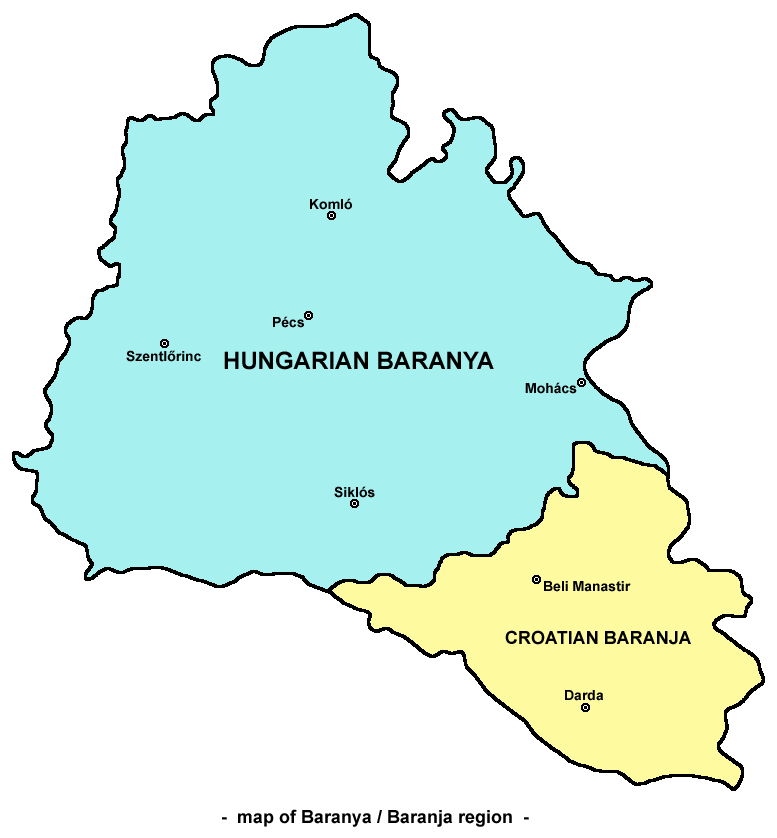
English: Map of Baranya / Baranja region in Hungary and Croatia. Note: it is generally accepted that southern and eastern borders of Baranya / Baranja are rivers Drava and Danube, while north-western borders are less clear. This map show north-western borders of the region in accordance with borders of historical Baranya county in the Kingdom of Hungary, but according to other interpretations, north-western border of Baranya / Baranja is either Mecsek mountain either Balaton lake.
Српски / srpski: Mapa Baranje / zemljovid Baranje u Mađarskoj i Hrvatskoj. Napomena: opšte / opće je prihvaćeno da južnu i istočnu granicu Baranje čine reke / rijeke Drava i Dunav, dok su severozapadne / sjeverozapadne granice manje jasne. Ova mapa / ovaj zemljovid prikazuje severozapadne / sjeverozapadne granice regiona / regije u saglasnosti sa granicama istorijske / povijesne Baranjske županije u Kraljevini Ugarskoj, ali prema drugim interpretacijama, severozapadnu / sjeverozapadnu granicu Baranje čine ili planina Meček ili jezero Balaton. |
| Dátum | 2006. május 24. (eredeti feltöltésének dátuma) |
| Forrás | Áthozva az en.wikipedia projektből a Commonsba. |
| Szerző | Original uploader and author was PANONIAN at English wikipedia. |
| Más változatok |
|


Licenc
Self made map by user:PANONIAN.
| PANONIAN a(z) angol Wikipédia projektből, a mű szerzője művét közkinccsé nyilvánította. Ez a világ minden részén érvényes. Egyes országokban ez jogilag nem lehetséges. Ha így van, akkor: PANONIAN jogot ad bárkinek, hogy bármilyen célból, feltétel nélkül használhassa ezt a fájlt, kivéve a törvény által kötelezően előírt feltételeket. |
References
- Školski istorijski atlas, treće izdanje, Zavod za izdavanje udžbenika Socijalističke Republike Srbije, Beograd, 1970.
- Peter Rokai - Zoltan Đere - Tibor Pal - Aleksandar Kasaš, Istorija Mađara, Beograd, 2002.
- Nada Miletić Stanić, Pravoslavne crkve u Baranji, Novi Sad, 1999.
- Stevan Mihaldžić, Baranja od najstarijih vremena do danas, Beograd, 1991.
- http://upload.wikimedia.org/wikipedia/commons/9/99/Baranya_county_map_(1891).jpg
Eredeti feltöltési napló
Az eredeti leírólap itt volt. Az itt következő felhasználónevek az en.wikipedia projektre hivatkoznak.
- 2006-05-24 00:16 PANONIAN 732×779×8 (32939 bytes)
Fájltörténet
Kattints egy időpontra, hogy a fájl akkori állapotát láthasd.
| Dátum/idő | Bélyegkép | Felbontás | Feltöltő | Megjegyzés | |
|---|---|---|---|---|---|
| aktuális | 2009. október 15., 12:09 | | 777 × 838 (37 KB) | PANONIAN | |
| 2007. március 17., 00:42 |  | 732 × 779 (32 KB) | Frokor | ((Information |Description=Map of Baranya/en:Baranja region (self made) |Source=Originally from [http://en.wikipedia.org en.wikipedia]; description page is/was [http://en.wikipedia.org/w/index.php?title=Image%3ABARANYA.png he |
Fájlhasználat
Az alábbi lapok használják ezt a fájlt:
Globális fájlhasználat
A következő wikik használják ezt a fájlt:
- Használata itt: ar.wikipedia.org
- Használata itt: bg.wikipedia.org
- Használata itt: bs.wikipedia.org
- Használata itt: cs.wikipedia.org
- Használata itt: en.wikipedia.org
- Használata itt: es.wikipedia.org
- Használata itt: fr.wikipedia.org
- Használata itt: hr.wikipedia.org
- Használata itt: id.wikipedia.org
- Használata itt: ko.wikipedia.org
- Használata itt: nl.wikipedia.org
- Használata itt: nn.wikipedia.org
- Használata itt: no.wikipedia.org
- Használata itt: pl.wikipedia.org
- Használata itt: pt.wikipedia.org
- Használata itt: ro.wikipedia.org
- Használata itt: ru.wikipedia.org
- Használata itt: sh.wikipedia.org
- Használata itt: sk.wikipedia.org
- Használata itt: sv.wikipedia.org
- Használata itt: tr.wikipedia.org
- Használata itt: uk.wikipedia.org
- Használata itt: www.wikidata.org
- Használata itt: zh.wikipedia.org
- Használata itt: zh.wikivoyage.org
Text is available under the CC BY-SA 4.0 license; additional terms may apply.
Images, videos and audio are available under their respective licenses.
Cover photo is available under {{::mainImage.info.license.name || 'Unknown'}} license.
Cover photo is available under {{::mainImage.info.license.name || 'Unknown'}} license.
Credit:
(see original file).
