Dataja:Relief Map of Kazakhstan.png
Wulkosć tutoho přehlada: 800 × 457 pikselow. Druhe rozeznaća: 320 × 183 pikselow | 640 × 366 pikselow | 1.200 × 686 pikselow.
Wersija z wyšim rozeznaćom (1.200 × 686 pikselow, wulkosć dataje: 1,24 MB, typ MIME: image/png)
Zjeće
| wopis |
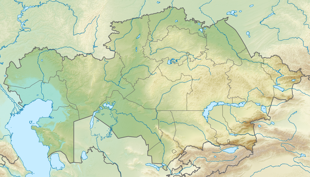
English: Location map of Kazakhstan
Equirectangular projection, N/S stretching 150 %. Geographic limits of the map:
|
| datum | |
| žórło |
|
| awtor |
|
| dowolnosć (dalewužiwanje tuteje dataje) |
Tuta dataja je pod licencu Creative Commons Attribution-Share Alike 3.0 Unported licencowana
|
Wersije dataje
Klikń na wěsty čas, zo by wersiju dataje w tutym času zwobraznił.
| Čas | Wobrazowy napohlad | Rozeznaće | Wužiwar | Komentar | |
|---|---|---|---|---|---|
| aktualnje | 9. oktobra 2022, 19:10 | | 1.200x686 (1,24 MB) | NordNordWest | upd 2022 |
| 26. awgusta 2010, 21:41 |  | 1.200x686 (1,39 MB) | Виктор В | ==((int:filedesc))== ((Information |Description=((en|Location map of Kazakhstan)) Equirectangular projection, N/S stretching 150 %. Geographic limits of the map: * N: 56° N * S: 40° N * W: 46° E * E: 88° E |Source=*[[:File:Kazakhsta |
Datajowe wužiwanje
Dataja so na slědowacych stronach wužiwa:
- Abaj (město)
- Ajagoz
- Akkol
- Aksaj (Kazachstan)
- Aksu
- Aktau
- Aktobe
- Alga
- Almaty
- Aral
- Aralski jězor
- Arkalyk
- Arys
- Astana
- Atbasar
- Atyrau
- Bajkonur
- Balkaš (město)
- Bulajewo
- Chromtau
- Deržawinsk
- Ekibastuz
- Embi
- Fort-Šewčenko
- Jerejmjentau
- Jesik
- Jesil
- Kandyagaš
- Kapšagaj
- Karaganda
- Karatau
- Karažal
- Karkaraly
- Kaskelen
- Kazaly
- Kentau
- Kokšetau
- Kostanaj
- Kulsary
- Kurčatow (Kazachstan)
- Kyzylorda
- Lenger
- Lisakowsk
- Makinsk
- Mamljutka
- Oral
- Oskemen
- Pawlodar
- Petropawl
- Priozjorsk
- Ridder
- Rudnyj
- Saran
- Sarkan
- Saryagaš
- Satbajew
- Semej
- Serebrjansk
- Sergejewka
- Stepnjak
- Stepnogorsk
- Tajynša
- Taldykorgan
- Talgar
- Taraz
- Tekeli
- Temir
- Temirtau
- Turkistan
- Ušaral
- Uštobe
- Zyrjanowsk
- Šachtinsk
- Šalkar
- Šar
- Šardara
- Šemonaicha
- Šu
- Šymkent
- Šćučinsk
- Žajsan
- Žanaozen
- Žanatas
- Žarkent
- Žem
- Žetisaj
- Žezkazgan
- Žitikara
- Předłoha:LocMap Kazachstan
Globalne wužiwanje dataje
Slědowace druhe wikije wužiwaja tutón wobraz:
- Wužiwanje na ar.wikipedia.org
- Wužiwanje na ast.wikipedia.org
- Wužiwanje na av.wikipedia.org
- Wužiwanje na azb.wikipedia.org
- Wužiwanje na az.wikipedia.org
- Balxaş
- Şablon:Yer xəritəsi Qazaxıstan
- Alagöl (Qazaxıstan)
- Mangistau yarımadası
- Aral gölü
- Vernı zəlzələsi (1887)
- Bozaşı yarımadası
- Spirkin Oseredok
- Janbay
- Durnev
- Tülen adaları
- Kulalı
- Manqışlaq körfəzi
- Böyük Peşnıye adaları
- Qazax körfəzi
- Kaydak körfəzi
- Myortvıy Kultuk körfəzi
- Qızılqum
- Üstyurd
- Mirzəçöl
- Aral Qaraqumu
- Çaqan gölü
- Bayanaul Milli Parkı
- İle-Alatau Milli Parkı
- Altın-Emel Milli Parkı
- Betpak-Dala
- Narın qumlar (səhra)
- Tauqum
- Jalqum
- Lyuqqum
- Barbıqum
- Böyük və Kiçik Porsuq
- Ayğırqum
- Sarıesik-Atırau
- Bestasqum
- Uzun-Aral
- Muyunqum
- Jamanqum
- Aralqum
- Barmaqqum
- Batpaysaqır
- Qaraqum (Almatı dairəsinin şimalında səhra)
- Qaraqum (Almatı dairəsinin cənubunda səhra)
- Muyunqum (Alma-ata dairsində səhra)
Globalne wužiwanje tuteje dataje pokazać
Metadaty
Text is available under the CC BY-SA 4.0 license; additional terms may apply.
Images, videos and audio are available under their respective licenses.
Cover photo is available under {{::mainImage.info.license.name || 'Unknown'}} license.
Cover photo is available under {{::mainImage.info.license.name || 'Unknown'}} license.
Credit:
(see original file).
