Bärenstein (Rudne horiny)
| ||
| Wopon | ||
|---|---|---|
| ||
| Zakładne daty | ||
| stat | ||
| zwjazkowy kraj | ||
| wokrjes | Rudnohórski | |
| wysokosć | 713 metrow n.m.hł. | |
| přestrjeń | 5,47 km² | |
| wobydlerstwo | 2.249 (31. dec 2023)[1] | |
| hustosć zasydlenja | 411 wob. na km² | |
| póstowe čisło | 09471 | |
| předwólba | (+49) 037347 | |
| awtowa značka | ERZ, ANA, ASZ, AU, MAB, MEK, STL, SZB, ZP | |
| Politika a zarjadnistwo | ||
| wyši měšćanosta | Silvio Wagner (bjezstronski) | |
| adresa | Oberwiesenthaler Str. 14 09471 Bärenstein | |
| webstrona | baerenstein-erzgebirge.de | |
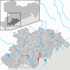
| Połoženje w Sakskej | ||
 | ||
wikidata: Bärenstein (Q57714)
| ||


Bärenstein je wjes a gmejna w sakskim Rudnohórskim wokrjesu při hranicy Čěskeje a Němskeje. Leži při zwjazkowej dróze 95 w Rudnych horinach we wysokosći 710 metrow nad mórskej hładźinu. Ma něhdźe dwaj tysac wobydlerjow.
Geografija
[wobdźěłać | žórłowy tekst wobdźěłać]Gmejna leži při hrjebjenju srjedźnych Rudnych horin bjezposrědnje při čěskej hranicy a při rěčce Pöhlbach.
Na čěskim boku leža Vejprty na wuchodźe. Susodne gmejny w Sakskej su Königswalde na sewjeru, Sehmatal na zapadźe, a Oberwiesenthal na juhu.
Wobrazarnja
[wobdźěłać | žórłowy tekst wobdźěłać]-
 Radnica
 -
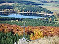 Hora Bärenstein a rěčna zawěra Cranzahl
 -
 Hraničny přechod Vejprty/Bärenstein
 -
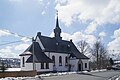 Romsko-katolska cyrkej swjateho Bonifacija
.jpg)


Stawizny
[wobdźěłać | žórłowy tekst wobdźěłać]Prěnje historiske naspomnjenje jako městnosć am Pernstein pochadźa z lěta 1525. Wjes bě so započatk 16. lětstotka załožiła. Bärensteinska kapałka bě hač do lěta 1657 filiala Königswaldskeje a wot toho lěta samostatna wosadna cyrkej.[2]
Wobchad
[wobdźěłać | žórłowy tekst wobdźěłać]W Bärensteinje je wot lěta 1872 dwórnišćo železniskeje čary Vejprty – Annaberg-Buchholz – Kamjenica.
Politika
[wobdźěłać | žórłowy tekst wobdźěłać]Bärenstein słuša k sakskemu wólbnemu wokrjesej 16 (Rudne hory 4) a k zwjazkowemu wólbnemu wokrjesej 164 (Rudne hory I).
Žórła
[wobdźěłać | žórłowy tekst wobdźěłać]- ↑ Aktualne ličby wobydlerstwa po gmejnach 2023; Statistiski krajny zarjad Sakskeje
- ↑ Bärenstein w Digitalnym stawizniskim zapisu městnow Sakskeje (němsce)
Wotkazaj
[wobdźěłać | žórłowy tekst wobdźěłać]Amtsberg | Annaberg-Buchholz | Aue | Auerbach | Bad Schlema | Bärenstein | Bockau | Börnichen | Breitenbrunn | Burkhardtsdorf | Crottendorf | Deutschneudorf | Drebach | Ehrenfriedersdorf | Eibenstock | Elterlein | Gelenau | Geyer | Gornau | Gornsdorf | Großolbersdorf | Großrückerswalde | Grünhain-Beierfeld | Grünhainichen | Heidersdorf | Hohndorf | Jahnsdorf | Johanngeorgenstadt | Jöhstadt | Königswalde | Seiffen | Lauter-Bernsbach | Lěsnica (Lößnitz) | Lugau | Marienberg | Mildenau | Neukirchen | Niederdorf | Niederwürschnitz | Oberwiesenthal | Olbernhau | Pockau-Lengefeld | Raschau-Markersbach | Sapawa (Zschopau) | Scheibenberg | Schlettau | Schneeberg | Schönheide | Schwarzenberg | Sehmatal | Stollberg | Stützengrün | Tannenberg | Thalheim | Thermalbad Wiesenbad | Thum | Wolešnica | Wolkenstein | Zschorlau | Zwonica (Zwönitz)
Text is available under the CC BY-SA 4.0 license; additional terms may apply.
Images, videos and audio are available under their respective licenses.
