Datoteka:Czechoslovakia01.png
Veličina ovog prikaza: 800 × 340 piksela. Ostale razlučivosti: 320 × 136 piksela | 1.100 × 468 piksela.
Vidi sliku u punoj veličini (1.100 × 468 piksela, veličina datoteke: 63 KB, MIME tip: image/png)
| Ova se datoteka nalazi na Zajedničkom poslužitelju i mogu je rabiti drugi projekti. Ispod je prikazan opis s njezine tamošnje stranice. |
Sažetak
| Opis |
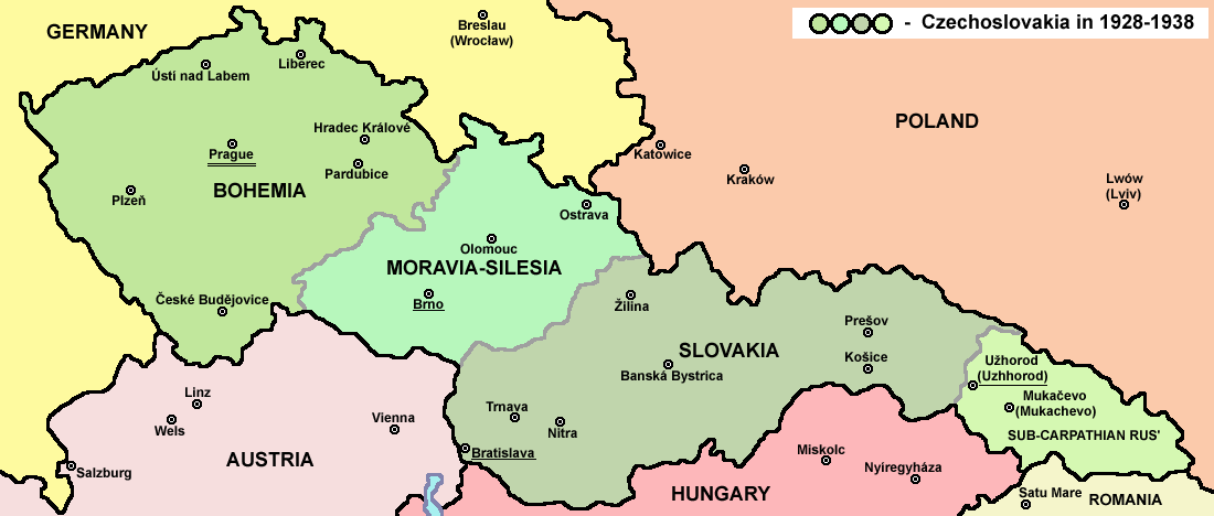
English: Map of Czechoslovakia in 1928-1938. Note: The provinces shown on the map were introduced by Act No. 125/1927 Zb. and became effective in 1928. Deutsch: Karte der Tschechoslowakei zwischen 1928 und 1938. |
||
| Datum | |||
| Izvor |
Vlastito djelo postavljača Main reference:
Secondary references with similar maps:
Secondary references about Geo-political situation - published sources:
Secondary reference about sizable cities: |
||
| Autor |
PANONIAN
|
||
| Dopuštenje (Naknadna uporaba ove datoteke) |
|
||
| Ostale inačice |
Radovi izvedeni od ove datoteke: |


|
This map image could be re-created using vector graphics as an SVG file. This has several advantages; see Commons:Media for cleanup for more information. If an SVG form of this image is available, please upload it and afterwards replace this template with
((vector version available|new image name)).
It is recommended to name the SVG file “Czechoslovakia01.svg”—then the template Vector version available (or Vva) does not need the new image name parameter. |
The production, editing or release of this file was supported by the Community-Budget of Wikimedia Deutschland. To see other files made with the support of Wikimedia Deutschland, please see the category Supported by Wikimedia Deutschland. |
Povijest datoteke
Kliknite na datum/vrijeme kako biste vidjeli datoteku kakva je tada bila.
| Datum/Vrijeme | Minijatura | Dimenzije | Suradnik | Komentar | |
|---|---|---|---|---|---|
| sadašnja | 16:48, 12. srpanj 2022. | | 1.100 × 468 (63 KB) | Sebastian Wallroth | cropped |
| 12:54, 19. svibanj 2011. |  | 1.128 × 513 (63 KB) | WikiEditor2004 | minor change, marked provincial capitals | |
| 11:53, 17. svibanj 2011. |  | 1.128 × 513 (62 KB) | WikiEditor2004 | Reverted to version as of 10:38, 24 April 2011 - because this is map of Czechoslovakia and it was capital of Czechoslovakia | |
| 07:07, 17. svibanj 2011. |  | 1.128 × 513 (55 KB) | Millenium187 | Why was Prague underlined and Vienna, Brno, Bratislava and other capital cities were not? -- corrected | |
| 12:38, 24. travanj 2011. |  | 1.128 × 513 (62 KB) | WikiEditor2004 | few corrections | |
| 13:31, 23. travanj 2011. |  | 1.128 × 509 (61 KB) | WikiEditor2004 | improved version | |
| 22:58, 20. prosinac 2008. |  | 1.100 × 497 (78 KB) | Kirk979 | ((Information |Description= |Source= |Date= |Author= |Permission= |other_versions= )) | |
| 18:11, 28. prosinac 2006. |  | 1.100 × 497 (90 KB) | Electionworld | ((ew|en|PANONIAN)) Map of ((link|Czechoslovakia)) (self made) Note: The provinces shown on the map were introduced by Act No. 125/1927 Zb. and became effective in 1928. ((PD-self)) Category:Maps of Czechoslovakia Category:Maps of Czech history |
Uporaba datoteke
Na ovu sliku vode poveznice sa sljedećih stranica:
Globalna uporaba datoteke
Sljedeći wikiji rabe ovu datoteku:
- Uporaba na af.wikipedia.org
- Uporaba na als.wikipedia.org
- Uporaba na ang.wikipedia.org
- Uporaba na an.wikipedia.org
- Uporaba na ar.wikipedia.org
- Uporaba na arz.wikipedia.org
- Uporaba na azb.wikipedia.org
- Uporaba na az.wikipedia.org
- Uporaba na ba.wikipedia.org
- Uporaba na bcl.wikipedia.org
- Uporaba na be-tarask.wikipedia.org
- Uporaba na be.wikipedia.org
- Uporaba na bg.wikipedia.org
- Uporaba na bn.wikipedia.org
- Uporaba na br.wikipedia.org
- Uporaba na ca.wikipedia.org
- Uporaba na cs.wikipedia.org
- Uporaba na cv.wikipedia.org
- Uporaba na cy.wikipedia.org
- Uporaba na de.wikipedia.org
- Uporaba na diq.wikipedia.org
- Uporaba na dsb.wikipedia.org
- Uporaba na el.wikipedia.org
- Uporaba na en.wikipedia.org
Pogledajte globalnu uporabu ove datoteke.
Metapodatci
Text is available under the CC BY-SA 4.0 license; additional terms may apply.
Images, videos and audio are available under their respective licenses.
Cover photo is available under {{::mainImage.info.license.name || 'Unknown'}} license.
Cover photo is available under {{::mainImage.info.license.name || 'Unknown'}} license.
Credit:
(see original file).
