קובץ:K-T boundary.jpg
אין גרסה ברזולוציה גבוהה יותר.
K-T_boundary.jpg (720 × 458 פיקסלים, גודל הקובץ: 322 ק"ב, סוג MIME: image/jpeg)
| זהו קובץ שמקורו במיזם ויקישיתוף. תיאורו בדף תיאור הקובץ המקורי (בעברית) מוצג למטה. |
תקציר
| תיאור |
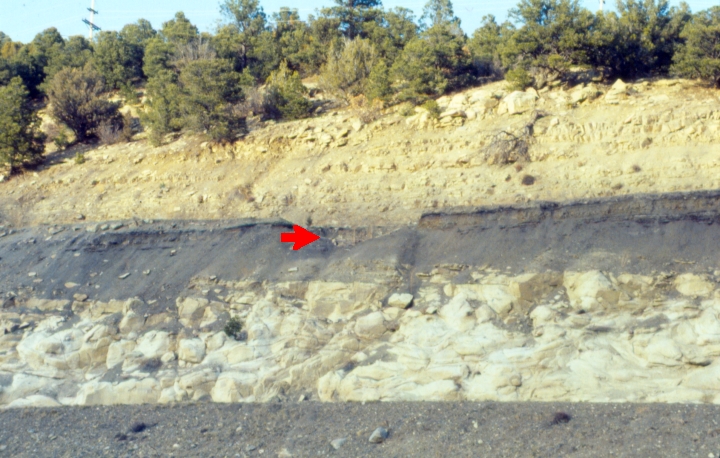
English: K-T boundary (red arrow) along Interstate 25, Raton Pass, Colorado Deutsch: KT-Grenze (Roter Pfeil) entlang der Interstate 25, Raton Pass, Colorado |
| תאריך יצירה | |
| מקור | נוצר על־ידי מעלה היצירה by Ank-man, first upload here |
| יוצר | Anky-man מוויקיפדיה האנגלית |
רישיון
Anky-man בוויקיפדיה האנגלית, בעל זכויות היוצרים על היצירה הזאת, מפרסם אותה בזאת תחת הרישיון הבא:

|
מוענקת בכך הרשות להעתיק, להפיץ או לשנות את המסמך הזה, לפי תנאי הרישיון לשימוש חופשי במסמכים של גנו, גרסה 1.2 או כל גרסה מאוחרת יותר שתפורסם על־ידי המוסד לתוכנה חופשית; ללא פרקים קבועים, ללא טקסט עטיפה קדמית וללא טקסט עטיפה אחורית. עותק של הרישיון כלול בפרק שכותרתו הרישיון לשימוש חופשי במסמכים של גנו. |
| הקובץ הזה מתפרסם לפי תנאי רישיון קריאייטיב קומונז ייחוס-שיתוף זהה 3.0 לא מותאם. | ||
| ייחוס: Anky-man | ||
| ||
| תבנית רישוי זו הוספה לקובץ כחלק מעדכון רישיון GFDL. |
יומן העלאה מקורי
(All user names refer to en.wikipedia)
- 2007-04-16 16:35 Anky-man 720×458×8 (329312 bytes) == ((int:filedesc)) == ((Information| |Description =K-T boundary (red arrow) along Interstate 25, Raton Pass, Colorado |Source=((own)) by Ank-man |Date = April, 1992 |Author = ~~~~ |Permission = I grant use of this image. ))
היסטוריית הקובץ
ניתן ללחוץ על תאריך/שעה כדי לראות את הקובץ כפי שנראה באותו זמן.
| תאריך/שעה | תמונה ממוזערת | ממדים | משתמש | הערה | |
|---|---|---|---|---|---|
| נוכחית | 23:21, 21 בספטמבר 2007 | | 458 × 720 (322 ק"ב) | Polarlys | ((Information |Description=((en|K-T boundary (red arrow) along Interstate 25, Raton Pass, Colorado)) |Source=self-made by Ank-man, first upload [http://en.wikipedia.org/w/index.php?title=Image%3AK-T_boundary.jpg here] |Date=April, 1992 |Author=[[:en:User: |
שימוש בקובץ
הדף הבא משתמש בקובץ הזה:
שימוש גלובלי בקובץ
אתרי הוויקי השונים הבאים משתמשים בקובץ זה:
- שימוש באתר ast.wikipedia.org
- שימוש באתר bg.wikipedia.org
- שימוש באתר bs.wikipedia.org
- שימוש באתר cs.wikipedia.org
- שימוש באתר da.wikipedia.org
- שימוש באתר en.wikipedia.org
- שימוש באתר eo.wikipedia.org
- שימוש באתר es.wikipedia.org
- שימוש באתר fi.wikipedia.org
- שימוש באתר hu.wikipedia.org
- שימוש באתר hy.wikipedia.org
- שימוש באתר id.wikipedia.org
- שימוש באתר it.wikipedia.org
- שימוש באתר kw.wikipedia.org
- שימוש באתר mk.wikipedia.org
- שימוש באתר nl.wikipedia.org
- שימוש באתר nn.wikipedia.org
- שימוש באתר no.wikipedia.org
- שימוש באתר vi.wikipedia.org
- שימוש באתר zh.wikipedia.org
מטא־נתונים
Text is available under the CC BY-SA 4.0 license; additional terms may apply.
Images, videos and audio are available under their respective licenses.
Cover photo is available under {{::mainImage.info.license.name || 'Unknown'}} license.
Cover photo is available under {{::mainImage.info.license.name || 'Unknown'}} license.
Credit:
(see original file).
