א-נזלה א-שרקיה
| טריטוריה |
|
|---|---|
| נפה | טולכרם |
| גובה | 215 מטרים |
| אוכלוסייה | |
| ‑ בכפר | 1,647 (2006) |
| קואורדינטות | 32°24′42″N 35°06′29″E / 32.411738888889°N 35.107925°E |
| אזור זמן | UTC +2 |
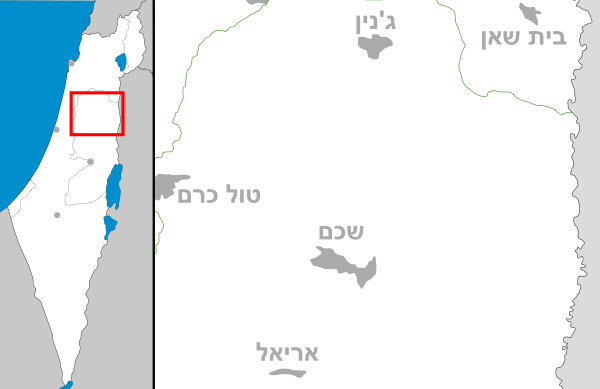
א-נזלה א-שרקיה (בערבית: النزلة الشرقية) הוא כפר פלסטיני בנפת טולכרם שבצפון מערב השומרון, הממוקם כ-18 ק"מ צפונית-מזרחית לטולכרם.
מקור השם
[עריכת קוד מקור | עריכה]בערבית, השרש نزل נ.ז.ל. מורה על ירידה ועל פי וילנאי [1] מדובר במקום שתושבי ההרים הסמוכים היו יורדים אליו לעבד את האדמה ואף לגור שם. משמעות המלה השנייה היא - המזרחית ואכן כפר הזה שוכן ממזרח לשני הכפרים א-נזלה אל-ע'רביה (המערבית) ואל-נזלה אל-וואסטא (האמצעית).
היסטוריה
[עריכת קוד מקור | עריכה]בשטח הכפר נמצאו שרידי חרסים מימי הביניים ומהאימפריה העות'מאנית.[2]
במפת הקרן לחקר ארץ ישראל שפורסמה ב-1882 הכפר תואר כ"קטן, מלט, עם בארות מים בדרומו וכמה עצי זיתים. הוא ניצב על אדמה גבוהה ויש עצי דקל בסביבתו."[3]
אוכלוסייה
[עריכת קוד מקור | עריכה]| מפקדי אוכלוסין | ||
| שנה | מס' תושבים | הערות |
| 1931 | 256 | [4] |
| 1945 | 300 | [5] |
| 1961 | 507 | |
| 1997 | 1,460 | |
| 2017 | 1,623 | [6] |
רוב תושבי הכפר הם בני משפחת כָּתָאנה [7]
בשנת 1997 - 5.4% מתושבי א-נזלה א-שרקיה היו פליטים .[8]
קרקעות
[עריכת קוד מקור | עריכה]בסקר הכפרים של 1945 נמצא כי שטח היה כ-4,840 דונם. מתוכם 723 דונם היו מטעים ואדמה להשקיה, 268 שימשו לגידול דגנים,[9] ואילו 5 דונם היו אדמות בנויות.[10]
קישורים חיצוניים
[עריכת קוד מקור | עריכה]סרטון על הכפר "ממעוף הציפור": https://www.youtube.com/watch?v=FEKHwu9OolI&t=5s&ab_channel=FajerTV
הערות שוליים
[עריכת קוד מקור | עריכה]- ^ זאב וילנאי, אריאל - אנציקלופדיה לידיעת הארץ, עם עובד, 1976, עמ' 5111
- ^ Zertal, 2016, pp. 362-363
- ^ Conder and Kitchener, 1882, SWP II, p. 153
- ^ Mills, 1932, p. 70
- ^ Palestine Remembered, النزله الشرقيه - al-Nazla al-Sharqiya א-נזלה א-שרקיה, Palestine Remembered
- ^ Palestinian Central Bureau of Statistics, Census 2017, נראה ב: https://pcbs.gov.ps/Downloads/book2364-1.pdf, 2018, עמ' 66
- ^ عبدالاله كتانة - עבד אל איללה כתאנה, قرية النزلة الشرقية - כפר א-נזלה א-שרקיה, Palestine Remembered
- ^ Palestinian Population by Locality and Refugee Status Palestinian Central Bureau of Statistics
- ^ Government of Palestine, Department of Statistics. Village Statistics, April, 1945. Quoted in Hadawi, 1970, p. 127
- ^ Government of Palestine, Department of Statistics. Village Statistics, April, 1945. Quoted in Hadawi, 1970, p. 177
| ערים | טולכרם (מכילה את השכונות: שוויכה, אירתח) | 
|
| מועצות מקומיות | ענבתא • עתיל • בלעא • באקה א-שרקייה • בית ליד • דיר אל-ע'וסון • קפין | |
| כפרים | פרעון • איכתאבא • עילאר • עזבת שופה • אל-ג'ארושיה • כפר עבוש • כפר ג'מאל • כפר א-לבד • כפר רמאן • כפר סור • כפר זיבאד • ח'ירבת חורייש • כור • א-נזלה אל-ע'רביה • א-נזלה א-שרקיה • נזלה אל-ווסטא • נזלת אבו נאר • נזלת עיסא • רמל זיתא • רמין • א-ראס • ספארין • סידא • שופא • סיר • זיתא | |
| מחנות פליטים | נור שמס | |
| נפות הרשות הפלסטינית | ||
Text is available under the CC BY-SA 4.0 license; additional terms may apply.
Images, videos and audio are available under their respective licenses.


