For faster navigation, this Iframe is preloading the Wikiwand page for Otaru.

Otaru

Modelo:Xeografía políticaOtaru
小樽市 (ja) Editar o valor en Wikidata
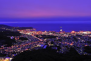
Vista nocturna
Fotomontaxe
Vista no inverno
Imaxe

Símbolo oficialTreron sieboldii (pt) Traducir (aves)
Rododendro (flor)
Betula platyphylla (árbore) Editar o valor en Wikidata
Localización
Editar o valor en Wikidata Mapa
 43°11′27″N 140°59′40″L / 43.19072, 140.99436Coordenadas: 43°11′27″N 140°59′40″L / 43.19072, 140.99436
EstadoXapón
PrefecturasHokkaido (en) Traducir
Sub-prefeitura (pt) TraducirSubprefectura de Shiribeshi Editar o valor en Wikidata
Poboación
Poboación112.452 (2020) Editar o valor en Wikidata (461,19 hab./km²)
Xeografía
Superficie243,83 km² Editar o valor en Wikidata
Bañado porIshikari Bay (en) Traducir Editar o valor en Wikidata
Comparte fronteira con
Datos históricos
Precedido por
Takashima (en) Traducir, Asari (en) Traducir e Shioya (en) Traducir Editar o valor en Wikidata
Creación20 de abril de 1922 Editar o valor en Wikidata
Sucedido porSapporo Editar o valor en Wikidata
Organización política
• Mayor of Otaru (en) Traducir Editar o valor en WikidataKazuo Shimura (en) Traducir (1975–1987)
Masa'aki Araya (en) Traducir (1987–1999)
Katsumaro Yamada (en) Traducir (1999–2011)
Yoshiharu Nakamatsu (en) Traducir (2011–2015)
Hideaki Morii (en) Traducir (2015–2018)
Toshiya Hazama (en) Traducir (2018–) Editar o valor en Wikidata
Órgano lexislativoQ61194579 Traducir , (Escano: 25) Editar o valor en Wikidata
Identificador descritivo
Código postal047-8660 Editar o valor en Wikidata
Fuso horario
Prefixo telefónico0134 Editar o valor en Wikidata
Outro
Irmandado con
Nakhodka (pt) Traducir (1966–)
Dunedin (1980–)
Gangseo District (en) Traducir (2009–) Editar o valor en Wikidata

Páxina webcity.otaru.lg.jp Editar o valor en Wikidata
Facebook: otarucity Twitter: OtaruCity Instagram: otaru_kurasi Editar o valor en Wikidata
Este artigo amosa escritos xaponeses. Sen o soporte axeitado, o texto pode mostrar símbolos sen sentido, coma caixas, marcas e outros.

Otaru (小樽市, おたるし, Otaru-shi) é un concello xaponés da subprefectura de Shiribeshi na prefectura de Hokkaidō. Está situado ao oeste da illa de Hokkaidō, no norte do Xapón. A súa superficie é de 243,30 km², a poboación é de 135.500 habitantes (2009) e ten unha densidade de poboación de 557 h/km².

O concello de Otaru limita cos concellos de Yoichi, Akaigawa (que son da subprefectura de Shiribeshi); de Sapporo e Ishikari (que son da subprefectura de Ishikari).

Véxase tamén

[editar | editar a fonte]

Outros artigos

[editar | editar a fonte]
{{bottomLinkPreText}} {{bottomLinkText}}
Otaru
Listen to this article

This browser is not supported by Wikiwand :(
Wikiwand requires a browser with modern capabilities in order to provide you with the best reading experience.
Please download and use one of the following browsers:

This article was just edited, click to reload
This article has been deleted on Wikipedia (Why?)

Back to homepage

Please click Add in the dialog above
Please click Allow in the top-left corner,
then click Install Now in the dialog
Please click Open in the download dialog,
then click Install
Please click the "Downloads" icon in the Safari toolbar, open the first download in the list,
then click Install
{{::$root.activation.text}}

Install Wikiwand

Install on Chrome Install on Firefox
Don't forget to rate us

Tell your friends about Wikiwand!

Gmail Facebook Twitter Link

Enjoying Wikiwand?

Tell your friends and spread the love:
Share on Gmail Share on Facebook Share on Twitter Share on Buffer

Our magic isn't perfect

You can help our automatic cover photo selection by reporting an unsuitable photo.

This photo is visually disturbing This photo is not a good choice

Thank you for helping!


Your input will affect cover photo selection, along with input from other users.

X

Get ready for Wikiwand 2.0 🎉! the new version arrives on September 1st! Don't want to wait?