Datei:Relief Map of Czech Republic.png
Grate faan detdiar föörskaubil: 800 × 486 pixel. Ööder apliasangen: 320 × 195 pixel | 640 × 389 pixel | 1.000 × 608 pixel.
Originaal datei (1.000 × 608 pixels, dateigrate: 866 KB, MIME-typ: image/png)
Beskriiwang
| Beskriiwang |
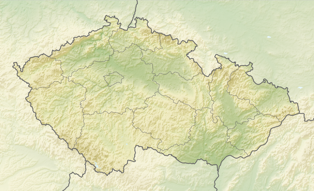
English: Relief map of the Czech Republic
Equirectangular projection, N/S stretching 150 %. Geographic limits of the map:
|
| Dootem | |
| Kwel |
|
| Skriiwer of Konstler | derivative work Виктор_В |
Lisens
Detdiar datei häält en lisens oner det Creative-Commons-lisens „Nööm nääm - Oner salew konditjuunen 3.0. Ei portiaret“.
- Dü mutst detdiar werk
- widjer du – detdiar werk kopiare an widjer du
- nei tuupstel – det werk feranre
- Oner jodiar konditjuunen:
- Nööm nääm – Dü skel di nööm faan di skriiwer of konstler nääm. Oober ei so, dat at so ütjsjocht, üs wan hi din werk gud fanjt.
- Oner josalew konditjuunen widjerdu – Wan dü detdiar werk feranerst, skel dü det resultaat oner detsalew lisens widjer du.
Datei wersioonen
Klike üüb en tidjponkt, am detdiar wersion uuntulukin.
| Dootem/Tidj | Föörskaubil | Miaten | Brüker | Komentaar | |
|---|---|---|---|---|---|
| aktuel | 10:37, 11. Jan. 2021 | | 1.000 × 608 (866 KB) | ThecentreCZ | Reverted to version as of 11:53, 28 August 2010 (UTC) V Ústavním pořádku České republiky nemají zemské hranice žádné ukotvení a jsou jen přežitkem |
| 00:48, 11. Jan. 2021 |  | 1.000 × 608 (780 KB) | Osidor | přidány zemské hranice (důvod: na mapě jsou užitečné nejméně stejně jako ty krajské [spíše však více]) | |
| 13:53, 28. Aug. 2010 |  | 1.000 × 608 (866 KB) | Виктор В | == ((int:filedesc)) == ((Information |Description=((en|Location map of the Czech Republic)) Equirectangular projection, N/S stretching 150 %. Geographic limits of the map: * N: 51.3° N * S: 48.3° N * W: 11.8° E * O: 19.2° |
Hü det datei brükt woort
Jodiar 15 sidjen brük detdiar datei:
Globaal brük faan datein
Jodiar ööder Wikis brük detdiar datei:
- Brük üüb als.wikipedia.org
- Brük üüb arz.wikipedia.org
- Brük üüb ast.wikipedia.org
- Brük üüb azb.wikipedia.org
- Brük üüb az.wikipedia.org
- Brük üüb ba.wikipedia.org
- Brük üüb be-tarask.wikipedia.org
- Brük üüb be.wikipedia.org
- Brük üüb bg.wikipedia.org
Muar globaal brük faan detdiar datei.
Metadooten
Text is available under the CC BY-SA 4.0 license; additional terms may apply.
Images, videos and audio are available under their respective licenses.
Cover photo is available under {{::mainImage.info.license.name || 'Unknown'}} license.
Cover photo is available under {{::mainImage.info.license.name || 'Unknown'}} license.
Credit:
(see original file).
