Vorotan (rivière)
| Vorotan | |
 Le Vorotan à Sisian | |
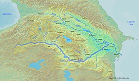
 Le Vorotan affluent nord - gauche - de l'Araxe dans le bassin de la Koura. | |
| Caractéristiques | |
|---|---|
| Longueur | 178 km [1] |
| Bassin | 5 650 km2 [2] |
| Bassin collecteur | Koura |
| Débit moyen | 19 m3/s [3] |
| Cours | |
| Source | Plateau du Karabagh |
| · Coordonnées | 39° 51′ 46″ N, 45° 51′ 10″ E |
| Confluence | Araxe |
| · Coordonnées | 39° 08′ 20″ N, 46° 50′ 20″ E |
| Géographie | |
| Principaux affluents | |
| · Rive gauche | Gorisget |
| · Rive droite | Sisian |
| Pays traversés | |
| Principales localités | Sisian |
| modifier |
|
Le Vorotan (en arménien Որոտան, en azéri Bazarçay) est une rivière de Transcaucasie, un affluent de l'Araxe (rive gauche), donc un sous-affluent de la Koura.
Géographie
[modifier | modifier le code]Il prend naissance à la frontière entre l'Arménie et le Haut-Karabagh, puis coule sur 111 km[1] dans ce pays (marz de Syunik) en direction du sud-est, et poursuit son cours dans le Haut-Karabagh[4] avant de se jeter dans l'Araxe à la frontière avec l'Iran. Il a formé sur son cours plusieurs canyons. Il traverse plusieurs villes, dont Sisian, et alimente des centrales hydroélectriques.
Le réservoir d'eau de Spandarian permet de stocker une partie de l'eau du Vorotan pour les besoins de l'irrigation et de la production hydroélectrique. C'est le deuxième réservoir d'eau douce du pays après le lac Sevan.
Au nord de la vallée du Vorotan, ce cours d'eau a donné son nom au col de Vorotan qui permet de relier l'Arménie méridionale au nord et à l'ouest du pays en franchissant la chaîne du Zanguézour.
Voir aussi
[modifier | modifier le code]Notes et références
[modifier | modifier le code]- (hy + en) Armstat, Armenia in Figures, « General Characteristic of the Republic of Armenia », (consulté le ).
- (en) Nations unies, Our Waters: Joining Hands Across Borders - First Assessment of Transboundary Rivers, Lakes and Groundwater, Nations unies, 2007 (ISBN 978-9211169720), p. 108.
- (hy + en) Armstat, Marzes of the Republic of Armenia and Yerevan City in Figures, « Geographic Characteristic of the Republic of Armenia », (consulté le ), p. 9.
- Pour le statut international du Haut-Karabagh, cf. l'article « Haut-Karabagh ».
Text is available under the CC BY-SA 4.0 license; additional terms may apply.
Images, videos and audio are available under their respective licenses.


