Voïvodie de Sieradz
| Voïvodie de Sieradz województwo sieradzkie | |
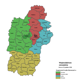
 Carte des 4 powiats. | |
| Administration | |
|---|---|
| Pays | |
| Capitale (Diétine) | Sieradz |
| Démographie | |
| Population | 411 500 hab. (1998) |
| Densité | 85 hab./km2 |
| Géographie | |
| Coordonnées | 51° 35′ 34″ nord, 18° 43′ 49″ est |
| Superficie | 486 800 ha = 4 868 km2 |
| Localisation | |
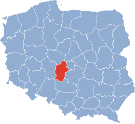
 Localisation de la voïvodie de 1975 à 1998 | |
| modifier |
|
La voïvodie de Sieradz (en polonais : województwo sieradzkie) était une unité de division administrative et un gouvernement local de Pologne entre 1975 et 1998.
Son territoire s'étendait sur 4 868 km2 et il est désormais couvert par la nouvelle voïvodie de Łódź, à la suite d'une loi de 1998 réorganisant le découpage administratif du pays.
En 1998, la voïvodie comptait 411 500 habitants.
La capitale de la voïvodie était Sieradz.
À la dissolution de la voïvodie, elle est remplacée et intégrée dans la nouvelle voïvodie de Łódź.
Gouverneurs de la voïvodie
[modifier | modifier le code]- Tadeusz Barczyk – du au
- Kazimierz Cłapka – du au
- Henryk Antosiak – du au
- Józef Szewczyk – du au
- Andrzej Ruszkowski – du au
- Jan Ryś – du jusqu'en 1997
- Kazimierz Filipiak – du au
Bureaux de district (Powiat)
[modifier | modifier le code]Sur la base de la loi du , les autorités locales de l'administration publique générale, ont créé 4 régions administratives associant une dizaine de municipalités.
- Bureau de district de Łask
- Gminy
- Bureau de district de Sieradz
- Gminy
- Ville
- Bureau de district de Wieluń
- Gminy
- Biała
- Czarnożyły
- Działoszyn
- Kiełczygłów
- Konopnica
- Lututów
- Mokrsko
- Osjaków
- Ostrówek
- Pątnów
- Rusiec
- Siemkowice
- Skomlin
- Wieluń
- Wierzchlas
- Bureau de district de Zduńska Wola
- Gminy
- Ville
Villes
[modifier | modifier le code]Population au :
 Zduńska Wola - 45 850
 Sieradz - 45 529
 Wieluń - 25 697
 Łask - 20 139
 Poddębice - 7 230
 Działoszyn – 6 200
 Złoczew – 3 450
 Warta – 3 400
 Błaszki – 2 100
 Szadek – 2 000
Démographie
[modifier | modifier le code]
Text is available under the CC BY-SA 4.0 license; additional terms may apply.
Images, videos and audio are available under their respective licenses.

