TanDEM-X
| Organisation |
|
|---|---|
| Constructeur | EADS Astrium |
| Domaine | Télédétection radar |
| Statut | Opérationnel |
| Autres noms | TDX |
| Lancement | 21 juin 2010 à 02 h 14 TU |
| Lanceur | Dnepr, depuis le Cosmodrome de Baïkonour |
| Durée | 5 ans (mission primaire) |
| Identifiant COSPAR | 2010-030A |
| Masse au lancement | 1 330 kg |
|---|---|
| Contrôle d'attitude | Stabilisé sur 3 axes |
| Source d'énergie | Panneaux solaires |
| Puissance électrique | 730 watts |
| Orbite | Héliosynchrone |
|---|---|
| Altitude | 514 km |
| Inclinaison | 97,44° |
| Radar SAR | Radar à synthèse d'ouverture |
|---|
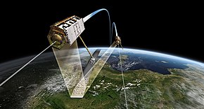
TanDEM-X (TerraSAR-X add-on for Digital Elevation Measurement) est un satellite radar, jumeau du satellite TerraSAR-X, mis en œuvre dans un partenariat public-privé entre le Deutsches Zentrum für Luft- und Raumfahrt (DLR) et EADS Astrium. Il utilise la technologie SAR (radar à synthèse d'ouverture), technologie moderne de l'imagerie radar.
Mission WorldDEM
[modifier | modifier le code]
TanDEM-X est aussi le nom de la mission comprenant les satellites jumeaux en formation étroite avec une distance contrôlée entre 250 et 500 m. L'objectif principal de la mission est la production du WorldDEM, un modèle numérique de terrain (MNT) mondial disponible à partir de 2014. La résolution de ce nouveau MNT est supérieure à l'actuel DTED2 : maille de 12 m sur 12, précision relative de 2 m et précision absolue de 10 m[1].
Infoterra GmbH, une filiale à 100 % d'Astrium, détient les droits de commercialisation exclusifs de WorldDEM. Elle est responsable de l'adaptation du MNT aux besoins des utilisateurs commerciaux à travers le monde.
Première image 3D
[modifier | modifier le code]La première image 3D issue de la mission TanDEM-X, est réalisée sur un groupe d'îles russes dans l'océan Arctique.
Références
[modifier | modifier le code]Liens externes
[modifier | modifier le code]Text is available under the CC BY-SA 4.0 license; additional terms may apply.
Images, videos and audio are available under their respective licenses.

