Sainte-Catherine (métro de Bruxelles)
| Sainte-Catherine Sint-Katelijne | ||||||||
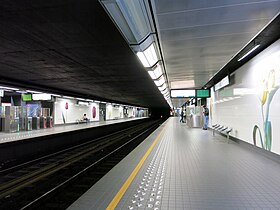
 Quais de la station « Sainte-Catherine » | ||||||||
| Localisation | ||||||||
|---|---|---|---|---|---|---|---|---|
| Pays | Belgique | |||||||
| Ville | Bruxelles | |||||||
| Commune | Bruxelles-ville | |||||||
| Coordonnées géographiques | 50° 51′ 08″ nord, 4° 20′ 52″ est | |||||||
| Caractéristiques | ||||||||
| Position par rapport au sol |
souterraine | |||||||
| Voies | 2 | |||||||
| Quais | 2 | |||||||
| Nombre d'accès | 6 | |||||||
| Accessibilité | Oui | |||||||
| Historique | ||||||||
| Mise en service | ||||||||
| Gestion et exploitation | ||||||||
| Exploitant | STIB | |||||||
| Ligne(s) | ||||||||
| ||||||||
| ||||||||
| modifier |
||||||||
Sainte-Catherine (en néerlandais : Sint-Katelijne) est une station des lignes 1 et 5 du métro de Bruxelles située à Bruxelles, sur la commune de Bruxelles-ville.
Situation
[modifier | modifier le code]La station de métro se situe sous la place entre le quai aux Briques à l'ouest et le quai au Bois à brûler à l'est et porte le nom de la place Sainte-Catherine voisine. Elle est sous-titrée Rue Antoine Dansaert (en néerlandais : Antoine Dansaertstraat) sur la signalétique.
Elle est située entre les stations Comte de Flandre et De Brouckère sur les lignes 1 et 5.
Histoire
[modifier | modifier le code]Station mise en service le .
Service aux voyageurs
[modifier | modifier le code]Accès
[modifier | modifier le code]La station compte six accès[1] :
- Accès no 1 : côté quai aux Briques, au centre (avec un ascenseur à proximité) ;
- Accès no 2 : côté quai au Bois à brûler, au sud ;
- Accès no 3 : côté quai aux Briques, au sud (accompagné d'un escalator) ;
- Accès no 4 : côté quai au Bois à brûler, au centre (avec un ascenseur à proximité) ;
- Accès no 5 : côté quai aux Briques, au nord (avec un ascenseur à proximité) ;
- Accès no 6 : côté quai au Bois à brûler, au nord.
La décoration de la station a été entièrement refaite en 2006. Les murs des quais sont maintenant décorés de céramiques présentant des tulipes.
Quais
[modifier | modifier le code]La station est de conception classique avec deux voies encadrées par deux quais latéraux.
Intermodalité
[modifier | modifier le code]La station n'est pas desservie par d'autres lignes de bus ou de tramway.
À proximité
[modifier | modifier le code]- Place Sainte-Catherine, connue pour ses restaurants spécialisés dans le poisson.
Notes et références
[modifier | modifier le code]- (fr + nl) STIB, « Plan de quartier de la station »
 [PDF], sur stib-mivb.be (consulté le ).
Voir aussi
[modifier | modifier le code]Articles connexes
[modifier | modifier le code]Liens externes
[modifier | modifier le code]Text is available under the CC BY-SA 4.0 license; additional terms may apply.
Images, videos and audio are available under their respective licenses.

