Ramberg (Rhénanie-Palatinat)
Cet article est une ébauche concernant une localité allemande.
Vous pouvez partager vos connaissances en l’améliorant (comment ?) selon les recommandations des projets correspondants.
| Ramberg | |||

| |||
_COA.svg) Armoiries |
|||
| Administration | |||
|---|---|---|---|
| Pays | |||
| Land | |||
| Arrondissement (Landkreis) |
Route-du-Vin-du-Sud | ||
| Bourgmestre (Ortsbürgermeister) |
Dieter Schwarzmann | ||
| Code postal | 76857 | ||
| Code communal (Gemeindeschlüssel) |
07 2 35 064 | ||
| Indicatif téléphonique | 06345 | ||
| Immatriculation | SÜW | ||
| Démographie | |||
| Population | 979 hab. (2009) | ||
| Densité | 126 hab./km2 | ||
| Géographie | |||
| Coordonnées | 49° 15′ 44″ nord, 8° 00′ 34″ est | ||
| Altitude | 237 m |
||
| Superficie | 775 ha = 7,75 km2 | ||
| Localisation | |||
| Géolocalisation sur la carte : Allemagne
Géolocalisation sur la carte : Rhénanie-Palatinat
| |||
| Liens | |||
| Site web | www.ramberg.de | ||
| modifier |
|||


Ramberg est une municipalité de la Verbandsgemeinde Annweiler am Trifels, dans l'arrondissement de la Route-du-Vin-du-Sud, en Rhénanie-Palatinat, dans l'ouest de l'Allemagne.
-
 Maison de réunion
 -
 Musée du pinceau
 -
 Ramburghalle
 -
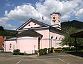 Église Saint-Laurent


Références
[modifier | modifier le code]- (en) Cet article est partiellement ou en totalité issu de l’article de Wikipédia en anglais intitulé « Ramberg, Rhineland-Palatinate » (voir la liste des auteurs).

Text is available under the CC BY-SA 4.0 license; additional terms may apply.
Images, videos and audio are available under their respective licenses.
Cover photo is available under {{::mainImage.info.license.name || 'Unknown'}} license.
Cover photo is available under {{::mainImage.info.license.name || 'Unknown'}} license.
Credit:
(see original file).
