Radnorshire
| Radnorshire / Sir Faesyfed | |

| |
| Administration | |
|---|---|
| Pays | |
| Nation | Pays de Galles |
| Chef-lieu | New Radnor (1536-?) Presteigne (1536-1889) Llandrindod Wells (1889-1974) |
| Dernier lord-lieutenant Mandat |
Michael Dillwyn-Venables-Llewelyn 1949-1974 |
| Dernier haut-shérif (en) Mandat |
Hubert John Watkins 1973 |
| Démographie | |
| Population | 18 271 hab. (1971) |
| Densité | 15 hab./km2 |
| Géographie | |
| Superficie | 1 218,77 km2 |
| Histoire et statut | |
| Création | 1536 |
| Dissolution | 1974 |
| modifier |
|
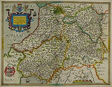
Le Radnorshire (en anglais) ou Sir Faesyfed (en gallois) est un comté historique du pays de Galles. Il constitue un comté administratif de 1536 à 1974, année de son incorporation au sein du nouveau comté de Powys.
Situé au cœur du pays de Galles central, il est tout au long de son histoire le plus petit, le moins peuplé et le plus pauvre des comtés gallois. Ses principales villes sont Llandrindod Wells (qui en est le dernier chef-lieu), Knighton, Presteigne et Rhayader.
Histoire
[modifier | modifier le code]
Le Radnorshire correspond à la région appelée Rhwng Gwy a Hafren « entre Wye et Severn » dans les sources galloises médiévales. Après l'invasion normande du pays de Galles, cette région est disputée entre les princes gallois et les seigneurs anglo-normands des familles de Briouze et Mortimer.
Les seigneuries des Marches galloises sont abolies en 1536 par les Laws in Wales Acts, qui réorganisent le pays de Galles en comtés sur le modèle anglais. La région comprise entre la Wye et la Severn constitue ainsi le nouveau comté du Radnorshire[1].
En vertu du Local Government Act 1888, un conseil de comté du Radnorshire est créé en 1889. Siégeant à Llandrindod Wells, il administre le Radnorshire jusqu'à son abolition en 1974 (Local Government Act 1972). La région constitue dès lors le district de Radnor (Radnorshire à partir de 1989) au sein du nouveau comté de Powys jusqu'en 1996, année de l'abolition des districts gallois. Un comité dédié au Radnorshire subsiste au sein du conseil de comté du Powys jusqu'en 2018[2].
Economie
[modifier | modifier le code]L'économie du Radnorshire repose essentiellement sur l'élevage ovin, même si quelques stations thermales se développent au XIXe siècle[1].
Subdivisions
[modifier | modifier le code]
À sa création, le Radnorshire est divisé en six hundreds :
- Colwyn
- Cefnllys
- Knighton
- Painscastle
- Radnor
- Rhayader
À partir de 1894 (Local Government Act 1894 (en)), le Radnorshire est divisé en cinq districts ruraux et trois districts urbains :
- Colwyn (rural)
- Knighton (rural)
- Knighton (urbain)
- Llandrindod Wells (urbain)
- New Radnor (rural)
- Painscastle (rural)
- Presteigne (urbain)
- Rhayader (rural)
Démographie
[modifier | modifier le code]
Articles connexes
[modifier | modifier le code]- Lord-lieutenant du Radnorshire
- Haut-shérif du Radnorshire (en)
Références
[modifier | modifier le code]- (en) Harold Carter, « Radnorshire », dans Robert Crowcroft et John Cannon (éd.), The Oxford Companion to British History, Oxford University Press, (ISBN 9780199677832, lire en ligne).
- (en) Elgan Hearn, « Montgomeryshire, Radnorshire, Brecknockshire abolished as shire committees are consigned to history », sur County Times, (consulté le ).
- (en) « Radnorshire AncC through time | Statistics », sur A Vision of Britain Through Time, GB Historical GIS / University of Portsmouth (consulté le ).
- (en) « Radnorshire AdmC through time | Statistics », sur A Vision of Britain Through Time, GB Historical GIS / University of Portsmouth (consulté le ).
Liens externes
[modifier | modifier le code]
- Notices dans des dictionnaires ou encyclopédies généralistes :
Text is available under the CC BY-SA 4.0 license; additional terms may apply.
Images, videos and audio are available under their respective licenses.
