Province de Huarochirí
| Province de Huarochirí | |
 Situation de la province de Huarochirí dans la Région | |
| Administration | |
|---|---|
| Pays | |
| Région | Lima |
| Chef-lieu | Matucana |
| Maire | Eveling Feliciano Ordoñez (2019-2022) |
| Démographie | |
| Population | 72 845 hab. (2007) |
| Densité | 13 hab./km2 |
| Géographie | |
| Coordonnées | 11° 50′ 41″ sud, 76° 23′ 02″ ouest |
| Superficie | 565 793 ha = 5 657,93 km2 |
| modifier |
|
La province de Huarochirí (en espagnol : Provincia de Huarochirí) est l'une des neuf provinces de la région de Lima, dans le centre du Pérou. Son chef-lieu est la ville de Matucana.
Géographie
[modifier | modifier le code]La province couvre une superficie de 5 657,93 km2. Elle est limitée au nord par la province de Canta, à l’est par la région de Junín, au sud par la province de Yauyos et la province de Cañete, et à l’ouest par la province de Lima. La partie occidentale de la province fait partie de l'agglomération de Lima ou Lima Metropolitana.

Histoire
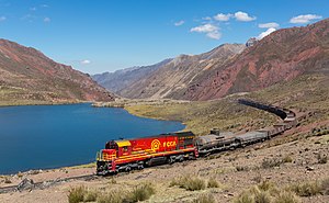
[modifier | modifier le code]La province porte le nom du village de Huarochirí, riche d'une longue histoire depuis la période inca. La capitale Matucana est située au centre de la province et est plus facile d'accès pour la plupart des habitants. Matucana se trouve dans la vallée du Río Rímac, sur la carreterra central et la voie ferrée reliant Lima à la région de Junín.
Les deux sites archéologiques les plus importants sont le plateau de Marcahuasi et la cité de Chuya (es).
Population
[modifier | modifier le code]La population de la province s'élevait à 72 845 habitants en 2007[1].
Subdivisions
[modifier | modifier le code]La province de Huarochirí est divisée en 32 districts :
- Antioquía
- Callahuanca
- Carampoma
- Chicla
- Cuenca
- Huachupampa
- Huanza
- Huarochirí
- Lahuaytambo
- Langa
- Laraos
- Mariatana
- Matucana
- Ricardo Palma
- San Andrés de Tupicocha
- San Antonio de Chaclla
- San Bartolomé
- San Damián
- San Juan de Iris
- San Juan de Tantaranche
- San Lorenzo de Quinti
- San Mateo
- San Mateo de Otao
- San Pedro de Casta
- San Pedro de Huancayre
- Sangallaya
- Santa Cruz de Cocachacra
- Santa Eulalia
- Santiago de Anchucaya
- Santiago de Tuna
- Santo Domingo de los Olleros
- San Jerónimo de Surco
Notes et références
[modifier | modifier le code]- INEI Consulté le 14 juillet 2010.
Liens externes
[modifier | modifier le code]Text is available under the CC BY-SA 4.0 license; additional terms may apply.
Images, videos and audio are available under their respective licenses.
