Pointe Marcel Kurz
| Pointe Marcel Kurz | |||||
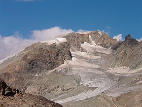
 Vue de la pointe Marcel Kurz depuis le refuge Nacamuli au col Collon. | |||||
| Géographie | |||||
|---|---|---|---|---|---|
| Altitude | 3 498 ou 3 499 m[1],[2] | ||||
| Massif | Alpes pennines (Alpes) | ||||
| Coordonnées | 45° 57′ 23″ nord, 7° 31′ 41″ est[1],[2] | ||||
| Administration | |||||
| Pays | |||||
| Canton Région à statut spécial |
Valais Vallée d'Aoste |
||||
| District Commune |
Hérens Bionaz |
||||
| Géolocalisation sur la carte : Suisse
Géolocalisation sur la carte : Italie
Géolocalisation sur la carte : canton du Valais
Géolocalisation sur la carte : Vallée d'Aoste
| |||||
| modifier |
|||||
La pointe Marcel Kurz (Punta Kurz en italien[3]) est un sommet des Alpes pennines culminant, selon les sources, à 3 498 ou 3 499 m d'altitude[1],[2], situé à la frontière entre l'Italie et la Suisse[2],[3],[4].
Toponymie
[modifier | modifier le code]La pointe Marcel Kurz est nommée en hommage à Marcel Kurz, topographe et auteur de guides suisse. Une autre pointe Kurz, située plus à l'ouest, à la frontière entre la Suisse et la France, est dédiée à son père Louis Kurz, alpiniste qui en fit la première ascension[5].
Géographie
[modifier | modifier le code]Située entre le mont Brûlé à l'est et la Vierge à l'ouest, elle domine le haut glacier d'Arolla au nord, du côté suisse, et le glacier du mont Brulé au sud, du côté italien[2],[6].
Références
[modifier | modifier le code]- Visualisation sur le géoportail italien.
- Visualisation sur Swisstopo.
- « Pointe Marcel Kurz sur Openstreetmap », sur openstreetmap.org (consulté le ).
- « Pointe Marcel Kurz 3499 m », sur www.sac-cas.ch (consulté le ).
- « Pointe Marcel Kurz », sur camptocamp.org (consulté le ).
- « Pointe Marcel Kurz : Face N - Voie de droite », sur www.camptocamp.org (consulté le ).
Text is available under the CC BY-SA 4.0 license; additional terms may apply.
Images, videos and audio are available under their respective licenses.


